Enable Location

We need your location to show you interesting places around you

Discover nearby places

Find interesting locations and hidden gems around you

Precise directions

Get accurate directions and distances to places

Your location is never shared with other users. It's only used when you tap the location button.

Log in to your account

Start exploring — it's free

Trusted by 62,612 travelers worldwide

Continue with Google
Continue with Apple
or

We will send you a code to connect

By continuing, you accept our Terms and Conditions and our Privacy Policy

Check your inbox

We've sent a pincode in your inbox. Please enter the code below.

Council Grove State Park

Council Grove State Park, State park in Missoula County, United States.

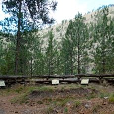
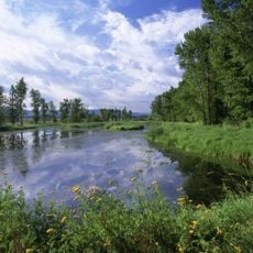
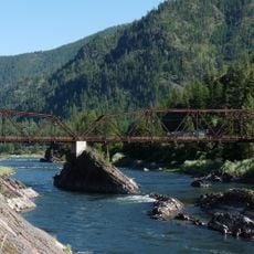
Council Grove State Park is a forested area near Missoula with stands of mature ponderosa pines, grassy open areas, and cottonwoods growing along the Clark Fork River. The park covers roughly 187 acres and includes about 1.5 miles of riverfront where the water has naturally carved out sandy beach-like banks.

An important agreement was signed here in 1855 between government representatives and leaders of multiple Native tribes from the region. This event marked a pivotal moment in how relationships developed between governmental authorities and the indigenous peoples of the area.

The site served as a meeting place where different groups came together to negotiate important agreements, a role reflected in the open spaces and layout you see today. Walking through the park gives you a sense of the conversations that shaped relationships in this region.

The park is easy to reach by car and provides plenty of space for walking and exploring among the trees and open areas. You can stroll along the riverfront, and the terrain is generally gentle with no steep sections to navigate.

The smooth, curved sandy banks along the river were created through natural erosion and now form small beach-like areas in an otherwise forested setting. This unexpected shoreline within the woods is a feature that catches many visitors off guard.

The community of curious travelers

AroundUs brings together thousands of curated places, local tips, and hidden gems, enriched daily by 60,000 contributors worldwide.

Start exploring
Location
Inception
1978
GPS coordinates
46.91300,-114.15500
Latest update
December 13, 2025 17:06
Around this place
Lake Missoula
United States of America

Lake Missoula

3 km
Washington–Grizzly Stadium
United States of America

Washington–Grizzly Stadium

14.3 km
The Garden of One Thousand Buddhas
United States of America

The Garden of One Thousand Buddhas

31.4 km
Traveler's Rest
United States of America

Traveler's Rest

20.2 km
Wilma Theater
United States of America

Wilma Theater

13.1 km
Fort Fizzle
United States of America

Fort Fizzle

19 km
Lee Metcalf National Wildlife Refuge
United States of America

Lee Metcalf National Wildlife Refuge

40.6 km
Missoula Public Library
United States of America

Missoula Public Library

13.4 km
The Payne Family Native American Center
United States of America

The Payne Family Native American Center

14.2 km
KettleHouse Amphitheater
United States of America

KettleHouse Amphitheater

22.7 km
Millennium Building
United States of America

Millennium Building

13.2 km
Missoula County Courthouse
United States of America

Missoula County Courthouse

12.9 km
Brinks House
United States of America

Brinks House

26.6 km
Masonic Lodge
United States of America

Masonic Lodge

13.2 km
Milltown State Park
United States of America

Milltown State Park

20.1 km
Alberton School
United States of America

Alberton School

26.9 km
Natural Pier Bridge
United States of America

Natural Pier Bridge

29.1 km
First Interstate Center
United States of America

First Interstate Center

13.1 km
A Carousel for Missoula
United States of America

A Carousel for Missoula

12.8 km
Marent Gulch Trestle
United States of America

Marent Gulch Trestle

10.3 km
Fred T. Sterling House
United States of America

Fred T. Sterling House

13.6 km
Mrs. Lydia McCaffery's Furnished Rooms
United States of America

Mrs. Lydia McCaffery's Furnished Rooms

12.7 km
Bellows Residence
United States of America

Bellows Residence

13.6 km
Apartment Building at 116 Spruce Street
United States of America

Apartment Building at 116 Spruce Street

13.1 km
Wilson House
United States of America

Wilson House

25.9 km
Chadwick House
United States of America

Chadwick House

26.6 km
Mineral Peak Lookout
United States of America

Mineral Peak Lookout

27.8 km
Milltown Bridge
United States of America

Milltown Bridge

21.2 km
Show the full map
« Council Grove State Park - State park in Missoula County, United States » is provided by Around Us (aroundus.com). Images and texts are derived from Wikimedia project under a Creative Commons license. You are allowed to copy, distribute, and modify copies of this page, under the conditions set by the license, as long as this note is clearly visible.

Discover hidden gems everywhere you go!

From secret cafés to breathtaking viewpoints, skip the crowded tourist spots and find places that match your style. Our app makes it easy with voice search, smart filtering, route optimization, and insider tips from travelers worldwide. Download now for the complete mobile experience.

Around Us App Screenshot

A unique approach to discovering new places

Le Figaro

All the places worth exploring

France Info

A tailor-made excursion in just a few clicks

20 Minutes

Around Us
Travel Guide & Maps
Download

Send to your phone

QR Code
1

Open the camera app on your mobile.

2

Point at the QR code with your camera. A notification will appear.

3

Tap the notification to open the link.