Enable Location

We need your location to show you interesting places around you

Discover nearby places

Find interesting locations and hidden gems around you

Precise directions

Get accurate directions and distances to places

Your location is never shared with other users. It's only used when you tap the location button.

Sunset Boulevard Bridge

Log in to your account

Start exploring — it's free

Trusted by 62,353 travelers worldwide

Continue with Google
Continue with Apple
or

We will send you a code to connect

By continuing, you accept our Terms and Conditions and our Privacy Policy

Check your inbox

We've sent a pincode in your inbox. Please enter the code below.

Sunset Boulevard Bridge

Sunset Boulevard Bridge, Road bridge in Spokane County, United States.

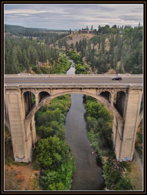
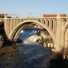
The Sunset Boulevard Bridge is a concrete arch bridge that crosses Latah Creek, linking Browne's Addition with Downtown Spokane and the West Hills. The structure features seven main semi-circular arches supported by smaller arches, creating a distinctive silhouette above the valley.

The bridge was built in 1911 by Morton McCartney and J.F. Cunningham, representing early adoption of concrete arch engineering in the region. It marked a shift toward modern construction methods that replaced older masonry techniques in bridge building.

The bridge represents early 20th-century engineering in Washington State, demonstrating the transition from traditional masonry to modern reinforced concrete construction methods.

The bridge carries daily traffic between neighborhoods and is widely used by drivers navigating the city. You can cross on foot or by vehicle and enjoy views into the gorge, though the road can be busy during peak hours.

Each of the seven main arches is supported by four smaller arches, creating a layered appearance that was specifically engineered for the sandy soil conditions along Latah Creek. This hidden structural complexity gives the bridge its distinctive depth when viewed from below.

The community of curious travelers

AroundUs brings together thousands of curated places, local tips, and hidden gems, enriched daily by 60,000 contributors worldwide.

Start exploring
Location
GPS coordinates
47.64985,-117.44760
Latest update
December 14, 2025 18:44
Around this place
Riverfront Park
United States of America

Riverfront Park

2.5 km
Spokane Falls
United States of America

Spokane Falls

2.2 km
Monroe Street Bridge
United States of America

Monroe Street Bridge

1.9 km
Fox Theatre
United States of America

Fox Theatre

1.7 km
Riverfront Park Carousel
United States of America

Riverfront Park Carousel

2.4 km
Patsy Clark Mansion
United States of America

Patsy Clark Mansion

664 m
Northwest Museum of Arts and Culture
United States of America

Northwest Museum of Arts and Culture

816 m
Cathedral of Our Lady of Lourdes
United States of America

Cathedral of Our Lady of Lourdes

1.8 km
Bing Crosby Theater
United States of America

Bing Crosby Theater

1.9 km
Spokane County Courthouse
United States of America

Spokane County Courthouse

2.2 km
The Parkade
United States of America

The Parkade

2.3 km
Knickerbocker
United States of America

Knickerbocker

2.2 km
Marycliff-Cliff Park Historic District
United States of America

Marycliff-Cliff Park Historic District

2 km
Review Building
United States of America

Review Building

1.8 km
Grace Baptist Church
United States of America

Grace Baptist Church

2 km
Empire State Building
United States of America

Empire State Building

2 km
Westminster United Church of Christ
United States of America

Westminster United Church of Christ

2.4 km
Riverside Avenue Historic District
United States of America

Riverside Avenue Historic District

1.6 km
Amman
United States of America

Amman

1.3 km
Coolidge–Rising House
United States of America

Coolidge–Rising House

1.2 km
Breslin
United States of America

Breslin

2.4 km
John A. Finch Memorial Nurses Home
United States of America

John A. Finch Memorial Nurses Home

1.8 km
Moore-Turner Garden
United States of America

Moore-Turner Garden

2 km
Old National Bank Building
United States of America

Old National Bank Building

2.3 km
Campbell House
United States of America

Campbell House

785 m
City Ramp Garage
United States of America

City Ramp Garage

2.3 km
Columbia Building
United States of America

Columbia Building

2.1 km
East Downtown Historic District
United States of America

East Downtown Historic District

2.3 km
Show the full map
« Sunset Boulevard Bridge - Road bridge in Spokane County, United States » is provided by Around Us (aroundus.com). Images and texts are derived from Wikimedia project under a Creative Commons license. You are allowed to copy, distribute, and modify copies of this page, under the conditions set by the license, as long as this note is clearly visible.

Discover hidden gems everywhere you go!

From secret cafés to breathtaking viewpoints, skip the crowded tourist spots and find places that match your style. Our app makes it easy with voice search, smart filtering, route optimization, and insider tips from travelers worldwide. Download now for the complete mobile experience.

Around Us App Screenshot

A unique approach to discovering new places

Le Figaro

All the places worth exploring

France Info

A tailor-made excursion in just a few clicks

20 Minutes

Around Us
Travel Guide & Maps
Download

Send to your phone

QR Code
1

Open the camera app on your mobile.

2

Point at the QR code with your camera. A notification will appear.

3

Tap the notification to open the link.