Albeni Falls Dam

Log in to your account

AroundUs is a community-driven map of interesting places, built by curious explorers like you. It grows with every review, story, and photo you share.
Connect to save your favorite spots, contribute locations, and create personalized routes.
Continue with Google
Continue with Apple
Continue with X
Continue with Facebook
Continue with email
By continuing, you accept our Terms and Conditions and our Privacy Policy
Create an account
Add to collection
Map
Suggest a change
Share

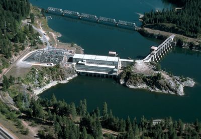
Albeni Falls Dam, Hydroelectric power station and gravity dam in Bonner County, US

Albeni Falls Dam is a concrete structure that spans across the Pend Oreille River between Oldtown and Priest River in northern Idaho. It holds back water to create a reservoir while housing generators and overflow channels that manage the river flow.

The project started in 1951 and was completed in 1955 as part of broader efforts to manage water resources and provide electricity to the Pacific Northwest. It represented a major investment in the region's infrastructure during that period.

The name comes from a waterfall associated with Albeni Poirier, an early settler in the region. Today, locals and visitors recognize the structure as a landmark that shaped the area's development.

The structure is visible from nearby roads and can be viewed from several public vantage points along the river. Access to certain operational areas is restricted for safety reasons, so plan your visit to use designated viewing areas.

The facility uses specialized turbine designs that handle large water volumes efficiently, a technology that was advanced for its era. This engineering approach allows the operation to maintain stable function across varying water levels.

Location: Bonner County

GPS coordinates: 48.17920,-117.00000

Latest update: December 11, 2025 11:09

Photos
Around this place
Silverwood Theme Park
United States of America

Silverwood Theme Park

37.3 km
Corkscrew
United States of America

Corkscrew

37.3 km
Farragut State Park
United States of America

Farragut State Park

39 km
Mount Saint Michael
United States of America

Mount Saint Michael

55.9 km
Colville National Forest
United States of America

Colville National Forest

49.7 km
Tremors
United States of America

Tremors

37.4 km
Spokane River Centennial State Park Trail
United States of America

Spokane River Centennial State Park Trail

54 km
Mount Spokane State Park
United States of America

Mount Spokane State Park

29.6 km
Fort Sherman
United States of America

Fort Sherman

57.8 km
Little Pend Oreille National Wildlife Refuge
United States of America

Little Pend Oreille National Wildlife Refuge

56.8 km
Round Lake State Park
United States of America

Round Lake State Park

27 km
Boulder Beach Water Park
United States of America

Boulder Beach Water Park

37.1 km
Clark House
United States of America

Clark House

51.4 km
Mount Kit Carson
United States of America

Mount Kit Carson

31.2 km
Kootenai County Courthouse
United States of America

Kootenai County Courthouse

58.1 km
Dover Church
United States of America

Dover Church

30.3 km
Post Falls Community United Presbyterian Church
United States of America

Post Falls Community United Presbyterian Church

52.2 km
Amanda Nesbitt House
United States of America

Amanda Nesbitt House

35.1 km
St. Stanislaus Kostka Mission
United States of America

St. Stanislaus Kostka Mission

41.8 km
Sandpoint Federal Building
United States of America

Sandpoint Federal Building

35.2 km
John A. Finch Caretaker's House
United States of America

John A. Finch Caretaker's House

50.2 km
Dr. John and Viola Phillips House and Office
United States of America

Dr. John and Viola Phillips House and Office

3.4 km
Samuel and Ann Young House
United States of America

Samuel and Ann Young House

52.3 km
Aftershock
United States of America

Aftershock

37.4 km
Harvey M. Davey House
United States of America

Harvey M. Davey House

58.3 km
Mount Spokane Vista House
United States of America

Mount Spokane Vista House

29.6 km
Museum of North Idaho
United States of America

Museum of North Idaho

58.4 km
Spirit Lake Historic District
United States of America

Spirit Lake Historic District

25.7 km
Show the full map
Reviews

Visited this place? Tap the stars to rate it and share your experience / photos with the community! Try now! You can cancel it anytime.

« Albeni Falls Dam - Hydroelectric power station and gravity dam in Bonner County, US » is provided by Around Us (aroundus.com). Images and texts are derived from Wikimedia project under a Creative Commons license. You are allowed to copy, distribute, and modify copies of this page, under the conditions set by the license, as long as this note is clearly visible.

Discover hidden gems everywhere you go!

From secret cafés to breathtaking viewpoints, skip the crowded tourist spots and find places that match your style. Our app makes it easy with voice search, smart filtering, route optimization, and insider tips from travelers worldwide. Download now for the complete mobile experience.

Around Us App Screenshot

A unique approach to discovering new places

Le Figaro

All the places worth exploring

France Info

A tailor-made excursion in just a few clicks

20 Minutes