Enable Location

We need your location to show you interesting places around you

Discover nearby places

Find interesting locations and hidden gems around you

Precise directions

Get accurate directions and distances to places

Your location is never shared with other users. It's only used when you tap the location button.

Lost Trail National Wildlife Refuge

Log in to your account

Start exploring — it's free

Trusted by 62,603 travelers worldwide

Continue with Google
Continue with Apple
or

We will send you a code to connect

By continuing, you accept our Terms and Conditions and our Privacy Policy

Check your inbox

We've sent a pincode in your inbox. Please enter the code below.

Lost Trail National Wildlife Refuge

Lost Trail National Wildlife Refuge, Nature reserve in Flathead County, United States.

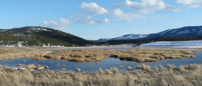
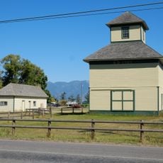
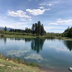
Lost Trail National Wildlife Refuge is a nature reserve in Montana featuring wetlands, streams, native intermountain prairie, and forests spread across 38,052 acres. The property connects different landscape types that support a wide range of plant and animal communities.

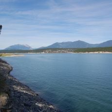
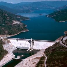
The refuge was established in 1999 as a mitigation effort to restore wetlands that were lost due to Kerr Dam operations affecting Flathead Lake. This compensation project aimed to replace ecological value that had been diminished elsewhere.

The U.S. Fish and Wildlife Service manages this land in collaboration with the Confederated Salish and Kootenai Tribes to protect essential wildlife corridors.

The refuge is located west of Kalispell along Highway 2, then accessed via Pleasant Valley Road. Early morning and late evening visits offer the best chances to observe wildlife in their natural patterns.

The refuge was developed collaboratively by the U.S. Fish and Wildlife Service and the Confederated Salish and Kootenai Tribes working together. This partnership created critical migration routes for large predators such as grizzly bears, Canada lynx, and wolverines moving between distant mountain ranges.

The community of curious travelers

AroundUs brings together thousands of curated places, local tips, and hidden gems, enriched daily by 60,000 contributors worldwide.

Start exploring
Location
Operator
US Fish and Wildlife Service
GPS coordinates
48.17741,-114.89300
Latest update
December 13, 2025 12:42
Around this place
Lake Koocanusa
United States of America

Lake Koocanusa

118.7 km
Libby Dam
United States of America

Libby Dam

40.2 km
Whitefish Lake State Park
United States of America

Whitefish Lake State Park

47.5 km
Montana Raceway Park
United States of America

Montana Raceway Park

43.1 km
Charles E. Conrad Mansion
United States of America

Charles E. Conrad Mansion

43.9 km
Lake Mary Ronan State Park
United States of America

Lake Mary Ronan State Park

47.1 km
West Shore State Park
United States of America

West Shore State Park

56.9 km
Soldiers' Home Historic District
United States of America

Soldiers' Home Historic District

54.4 km
Scandinavian Methodist Church
United States of America

Scandinavian Methodist Church

42.6 km
Kalispell Main Street Historic District
United States of America

Kalispell Main Street Historic District

43.2 km
Dayton State Bank
United States of America

Dayton State Bank

57.6 km
Courthouse Historic District
United States of America

Courthouse Historic District

43.3 km
First Presbyterian Church of Whitefish
United States of America

First Presbyterian Church of Whitefish

48.7 km
Woll House
United States of America

Woll House

42.9 km
A. J. Dean House
United States of America

A. J. Dean House

43.8 km
Snyder House
United States of America

Snyder House

42.3 km
Charles Boles House
United States of America

Charles Boles House

41.5 km
Conrad Mansion
United States of America

Conrad Mansion

43.8 km
Boyd's Shop
United States of America

Boyd's Shop

42.9 km
Fisher House
United States of America

Fisher House

42.7 km
Ray E. Taylor House
United States of America

Ray E. Taylor House

48.1 km
Beaman House
United States of America

Beaman House

42.7 km
Bruyer Granary
United States of America

Bruyer Granary

43.9 km
Bader-Jaquette and Westwang Houses and Rental Property
United States of America

Bader-Jaquette and Westwang Houses and Rental Property

42.5 km
Billsborough House
United States of America

Billsborough House

43.7 km
Pine Grove Pond Fishing Access Sign
United States of America

Pine Grove Pond Fishing Access Sign

45.7 km
Wanda Hollensteiner Art Gallery
United States of America

Wanda Hollensteiner Art Gallery

42.6 km
Frame Of Reference
United States of America

Frame Of Reference

48.7 km
Show the full map
« Lost Trail National Wildlife Refuge - Nature reserve in Flathead County, United States » is provided by Around Us (aroundus.com). Images and texts are derived from Wikimedia project under a Creative Commons license. You are allowed to copy, distribute, and modify copies of this page, under the conditions set by the license, as long as this note is clearly visible.

Discover hidden gems everywhere you go!

From secret cafés to breathtaking viewpoints, skip the crowded tourist spots and find places that match your style. Our app makes it easy with voice search, smart filtering, route optimization, and insider tips from travelers worldwide. Download now for the complete mobile experience.

Around Us App Screenshot

A unique approach to discovering new places

Le Figaro

All the places worth exploring

France Info

A tailor-made excursion in just a few clicks

20 Minutes

Around Us
Travel Guide & Maps
Download

Send to your phone

QR Code
1

Open the camera app on your mobile.

2

Point at the QR code with your camera. A notification will appear.

3

Tap the notification to open the link.