Enable Location

We need your location to show you interesting places around you

Discover nearby places

Find interesting locations and hidden gems around you

Precise directions

Get accurate directions and distances to places

Your location is never shared with other users. It's only used when you tap the location button.

Cloverly Formation

Log in to your account

Start exploring — it's free

Trusted by 65,586 travelers worldwide

Continue with Google
Continue with Apple
or

We will send you a code to connect

By continuing, you accept our Terms and Conditions and our Privacy Policy

Check your inbox

We've sent a pincode in your inbox. Please enter the code below.

Discussion Reviews 1 Photos
9.7k Popularity

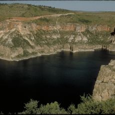
Cloverly Formation, Geological formation in Big Horn Basin, Wyoming, US.

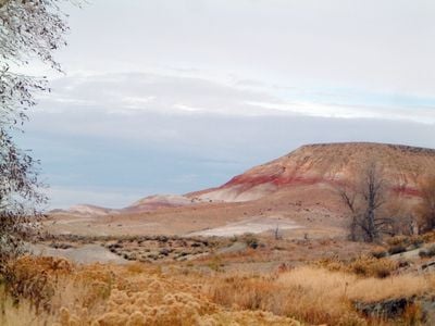
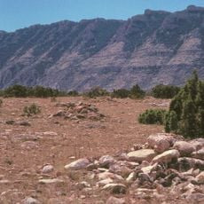
The Cloverly Formation is a geological layer in the Big Horn Basin in Wyoming made up of clay and sandstone deposits. The layers show distinct color variations from gray to reddish and contain many fossil remains from past eras.

The layer was first scientifically described in 1904 and named after a nearby post office located in the eastern part of the Big Horn Basin. This name helped geologists identify the formation clearly in their research.

The formation is known for its Early Cretaceous fossils, especially dinosaurs like Deinonychus and Tenontosaurus, which visitors can see in nearby museums. These remains tell the story of life in an ancient landscape millions of years ago.

The area is remote and requires careful planning for a visit, as there are few marked trails and facilities in the region. Visitors should bring local maps or ask for advice locally to find the best access points.

The mudstone deposits here preserve clues about different environments from about 120 million years ago, including traces of river settings and drier land areas. This variety of environments in a single layer is rare and gives researchers valuable insights into ancient ecosystems.

The community of curious travelers

AroundUs brings together thousands of curated places, local tips, and hidden gems, enriched daily by 60,000 contributors worldwide.

Start exploring
Location
Made from material
mudstone
GPS coordinates
44.83667,-108.39222
Latest update
March 10, 2026 22:24
Around this place
Medicine Wheel/Medicine Mountain National Historic Landmark
United States of America

Medicine Wheel/Medicine Mountain National Historic Landmark

37.1 km
Bighorn Canyon National Recreation Area
United States of America

Bighorn Canyon National Recreation Area

31.2 km
United States of America

Pryor Mountains Wild Horse Range

24.7 km
Natural Trap Cave
United States of America

Natural Trap Cave

21.9 km
United States of America

Petroglyph Canyon

20.8 km
Hyart Theater
United States of America

Hyart Theater

353 m
Bad Pass Trail
United States of America

Bad Pass Trail

20.8 km
Caroline Lockhart Ranch
United States of America

Caroline Lockhart Ranch

35.6 km
M L Ranch
United States of America

M L Ranch

18.5 km
Ewing-Snell Ranch
United States of America

Ewing-Snell Ranch

29.3 km
Cedarvale
United States of America

Cedarvale

32 km
EJZ Bridge over Shoshone River
United States of America

EJZ Bridge over Shoshone River

3.3 km
United States of America

Big Horn Academy Building

7.9 km
United States of America

John Blue Canyon

19.1 km
Cal S. Taggart Bighorn Canyon Visitor Center
United States of America

Cal S. Taggart Bighorn Canyon Visitor Center

1.2 km
Bighorn Canyon National Recreation Area (parke sa Estados Unidos, Wyoming)
United States of America

Bighorn Canyon National Recreation Area (parke sa Estados Unidos, Wyoming)

17 km
United States of America

Tony Island

35.1 km
United States of America

Caroline Lockhart Ranch

35.6 km
United States of America

Hillsboro

31.9 km
United States of America

Ewing-Snell Ranch

29.3 km
United States of America

Statue, Work of art

9.6 km
United States of America

Devil Canyon Overlook

23.4 km
United States of America

Bucking Mule Falls Observation Point

37.2 km
United States of America

Mustang Scenic Viewpoint

19.6 km
United States of America

Scenic Viewpoint

25.5 km
United States of America

Pulloff

28.2 km
United States of America

Scenic Viewpoint

26.7 km
United States of America

Bucking Mule Falls

37.5 km
Show the full map
Reviews
Share your experience

No review yet

Discussions
Start a discussion...

No discussion yet

« Cloverly Formation - Geological formation in Big Horn Basin, Wyoming, US » is provided by Around Us (aroundus.com). Images and texts are derived from Wikimedia project under a Creative Commons license. You are allowed to copy, distribute, and modify copies of this page, under the conditions set by the license, as long as this note is clearly visible.

Discover hidden gems everywhere you go!

From secret cafés to breathtaking viewpoints, skip the crowded tourist spots and find places that match your style. Our app makes it easy with voice search, smart filtering, route optimization, and insider tips from travelers worldwide. Download now for the complete mobile experience.

Around Us App Screenshot

A unique approach to discovering new places

Le Figaro

All the places worth exploring

France Info

A tailor-made excursion in just a few clicks

20 Minutes

Around Us
Travel Guide & Maps
Download

Send to your phone

QR Code
1

Open the camera app on your mobile.

2

Point at the QR code with your camera. A notification will appear.

3

Tap the notification to open the link.