Enable Location

We need your location to show you interesting places around you

Discover nearby places

Find interesting locations and hidden gems around you

Precise directions

Get accurate directions and distances to places

Your location is never shared with other users. It's only used when you tap the location button.

Bighorn Canyon National Recreation Area

Log in to your account

Start exploring — it's free

Trusted by 65,593 travelers worldwide

Continue with Google
Continue with Apple
or

We will send you a code to connect

By continuing, you accept our Terms and Conditions and our Privacy Policy

Check your inbox

We've sent a pincode in your inbox. Please enter the code below.

Bighorn Canyon National Recreation Area
Discussion Reviews 1 Photos
13k Popularity

Bighorn Canyon National Recreation Area, National Recreation Area in Montana and Wyoming, United States.

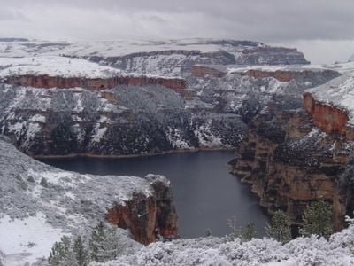
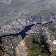
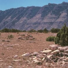
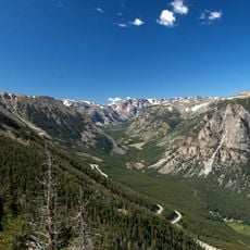
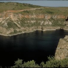
Bighorn Canyon National Recreation Area extends roughly 71 miles through Montana and Wyoming, bordered by steep limestone walls that rise about 1,000 feet (300 meters). Bighorn Lake sits at the heart of this canyon, surrounded by rugged terrain that opens into wider valleys at either end.

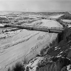
Congress established this recreation area in 1966 following the completion of Yellowtail Dam on the Bighorn River. The dam created the lake that now defines the landscape and recreational opportunities in the region.

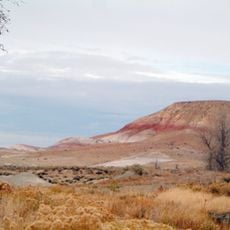
The Bad Pass Trail along the canyon's western side served as a vital pathway for Native American tribes moving through the region. Today, visitors can walk this historical route and experience the landscape that shaped generations of people.

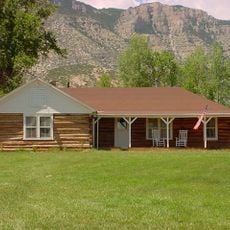
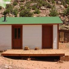
Two visitor centers provide information and guidance: one in the north near Fort Smith, Montana, and one in the south near Lovell, Wyoming. The area can be explored from both ends, each offering different trails and access points.

The area contains part of the Pryor Mountains Wild Horse Range, where mustangs roam freely within protected boundaries. These horses are descendants of animals that have lived in this landscape for generations.

The community of curious travelers

AroundUs brings together thousands of curated places, local tips, and hidden gems, enriched daily by 60,000 contributors worldwide.

Start exploring
Location
Location
Location
Inception
October 15, 1966
GPS coordinates
45.09873,-108.25104
Latest update
February 8, 2026 09:32
Around this place
Medicine Wheel/Medicine Mountain National Historic Landmark
United States of America

Medicine Wheel/Medicine Mountain National Historic Landmark

39.9 km
Cloverly Formation
United States of America

Cloverly Formation

31.2 km
Natural Trap Cave
United States of America

Natural Trap Cave

14.7 km
Chief Plenty Coups State Park and Home
United States of America

Chief Plenty Coups State Park and Home

43.3 km
Bighorn Lake
United States of America

Bighorn Lake

32.8 km
Hyart Theater
United States of America

Hyart Theater

31 km
Bad Pass Trail
United States of America

Bad Pass Trail

10.7 km
Ewing-Snell Ranch
United States of America

Ewing-Snell Ranch

1.9 km
Cedarvale
United States of America

Cedarvale

2.1 km
Bighorn Ditch Headgate
United States of America

Bighorn Ditch Headgate

33.7 km
EJZ Bridge over Shoshone River
United States of America

EJZ Bridge over Shoshone River

32.4 km
Lower Shell School House
United States of America

Lower Shell School House

69 km
Gebo Barn
United States of America

Gebo Barn

58.7 km
EJE Bridge over Shell Creek
United States of America

EJE Bridge over Shell Creek

72.1 km
United States of America

Ralston Community Clubhouse

63.7 km
Bearcreek Bank
United States of America

Bearcreek Bank

71.6 km
Forsman House
United States of America

Forsman House

55.9 km
Corey House
United States of America

Corey House

55.9 km
Hester E. Suydam Boarding House
United States of America

Hester E. Suydam Boarding House

61 km
Glidden House
United States of America

Glidden House

55.9 km
Joliet Bridge
United States of America

Joliet Bridge

70.5 km
Fromberg Opera House
United States of America

Fromberg Opera House

60.9 km
Fromberg Concrete Arch Bridge
United States of America

Fromberg Concrete Arch Bridge

60.1 km
Raymond Hough House
United States of America

Raymond Hough House

56.4 km
Samuel Greenblatt House
United States of America

Samuel Greenblatt House

61.1 km
Rock Creek
United States of America

Rock Creek

65.4 km
Cal S. Taggart Bighorn Canyon Visitor Center
United States of America

Cal S. Taggart Bighorn Canyon Visitor Center

30.7 km
Bighorn Canyon National Recreation Area (parke sa Estados Unidos, Wyoming)
United States of America

Bighorn Canyon National Recreation Area (parke sa Estados Unidos, Wyoming)

24 km
Show the full map
Reviews
Share your experience

No review yet

Discussions
Start a discussion...

No discussion yet

« Bighorn Canyon National Recreation Area - National Recreation Area in Montana and Wyoming, United States » is provided by Around Us (aroundus.com). Images and texts are derived from Wikimedia project under a Creative Commons license. You are allowed to copy, distribute, and modify copies of this page, under the conditions set by the license, as long as this note is clearly visible.

Discover hidden gems everywhere you go!

From secret cafés to breathtaking viewpoints, skip the crowded tourist spots and find places that match your style. Our app makes it easy with voice search, smart filtering, route optimization, and insider tips from travelers worldwide. Download now for the complete mobile experience.

Around Us App Screenshot

A unique approach to discovering new places

Le Figaro

All the places worth exploring

France Info

A tailor-made excursion in just a few clicks

20 Minutes

Around Us
Travel Guide & Maps
Download

Send to your phone

QR Code
1

Open the camera app on your mobile.

2

Point at the QR code with your camera. A notification will appear.

3

Tap the notification to open the link.