Enable Location

We need your location to show you interesting places around you

Discover nearby places

Find interesting locations and hidden gems around you

Precise directions

Get accurate directions and distances to places

Your location is never shared with other users. It's only used when you tap the location button.

Bighorn Lake

Log in to your account

Start exploring — it's free

Trusted by 62,589 travelers worldwide

Continue with Google
Continue with Apple
or

We will send you a code to connect

By continuing, you accept our Terms and Conditions and our Privacy Policy

Check your inbox

We've sent a pincode in your inbox. Please enter the code below.

Bighorn Lake

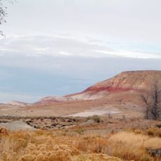
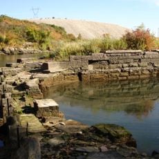
Bighorn Lake, body of water

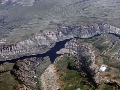
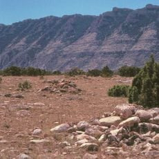
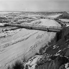
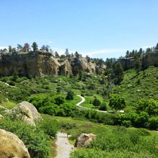
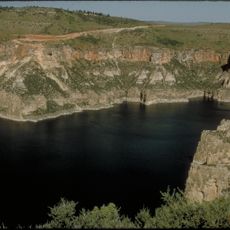
Bighorn Lake is a large reservoir spanning roughly 60 miles across the Wyoming-Montana border, created by the Yellowtail Dam finished in 1966. Towering limestone cliffs, hundreds of feet high, rise steeply from the water and dominate the landscape with layered rock formations.

The reservoir was created in 1966 when the Bureau of Reclamation completed the Yellowtail Dam. This construction transformed the river valley into a major water storage facility serving irrigation and water management needs across the region.

The name reflects the heritage of the Crow tribe, as the dam honors a respected tribal leader. Visitors experience this connection when learning about the region's indigenous roots while exploring the canyon and shoreline.

The area covers over 70,000 acres with access points and amenities spread throughout for boating, fishing, camping, and hiking. Two visitor centers provide maps and information to help you plan activities and learn about the natural and historical features.

During summer months, anglers can watch carp cruising the surface hunting for insects like cicadas that have fallen from nearby trees. This rare feeding behavior creates a special opportunity to encounter these large fish in an unexpected way.

The community of curious travelers

AroundUs brings together thousands of curated places, local tips, and hidden gems, enriched daily by 60,000 contributors worldwide.

Start exploring
Location
GPS coordinates
45.30780,-107.95700
Latest update
February 9, 2026 08:23
Around this place
Medicine Wheel/Medicine Mountain National Historic Landmark
United States of America

Medicine Wheel/Medicine Mountain National Historic Landmark

53.7 km
Pictograph Cave
United States of America

Pictograph Cave

61 km
Cloverly Formation
United States of America

Cloverly Formation

62.6 km
Natural Trap Cave
United States of America

Natural Trap Cave

41.6 km
Moss Mansion
United States of America

Moss Mansion

68.2 km
Little Bighorn Battlefield National Monument
United States of America

Little Bighorn Battlefield National Monument

50.7 km
Chief Plenty Coups State Park and Home
United States of America

Chief Plenty Coups State Park and Home

48.1 km
Rimrock Auto Arena at MetraPark
United States of America

Rimrock Auto Arena at MetraPark

68.2 km
Western Heritage Center
United States of America

Western Heritage Center

67.8 km
St. Patrick's Co-Cathedral
United States of America

St. Patrick's Co-Cathedral

68.2 km
Alberta Bair Theater
United States of America

Alberta Bair Theater

68.2 km
Hyart Theater
United States of America

Hyart Theater

62.3 km
Bad Pass Trail
United States of America

Bad Pass Trail

42.1 km
Ewing-Snell Ranch
United States of America

Ewing-Snell Ranch

34.6 km
Cedarvale
United States of America

Cedarvale

31.4 km
Bighorn Ditch Headgate
United States of America

Bighorn Ditch Headgate

989 m
EJZ Bridge over Shoshone River
United States of America

EJZ Bridge over Shoshone River

64.3 km
Pictograph Cave State Park
United States of America

Pictograph Cave State Park

60.5 km
St. Joseph's Catholic Church
United States of America

St. Joseph's Catholic Church

54.9 km
Masonic Temple
United States of America

Masonic Temple

68.1 km
First Baptist Church
United States of America

First Baptist Church

54.7 km
John Boyum House
United States of America

John Boyum House

54.7 km
Billings Chamber of Commerce Building
United States of America

Billings Chamber of Commerce Building

68.2 km
James J. Sullivan House
United States of America

James J. Sullivan House

54.4 km
Babcock Theatre
United States of America

Babcock Theatre

68 km
Saint Patrick Co-Cathedral (Billings, Montana)
United States of America

Saint Patrick Co-Cathedral (Billings, Montana)

68.2 km
Cal S. Taggart Bighorn Canyon Visitor Center
United States of America

Cal S. Taggart Bighorn Canyon Visitor Center

61.9 km
Bighorn Canyon National Recreation Area (parke sa Estados Unidos, Wyoming)
United States of America

Bighorn Canyon National Recreation Area (parke sa Estados Unidos, Wyoming)

50.2 km
Show the full map
« Bighorn Lake - body of water » is provided by Around Us (aroundus.com). Images and texts are derived from Wikimedia project under a Creative Commons license. You are allowed to copy, distribute, and modify copies of this page, under the conditions set by the license, as long as this note is clearly visible.

Discover hidden gems everywhere you go!

From secret cafés to breathtaking viewpoints, skip the crowded tourist spots and find places that match your style. Our app makes it easy with voice search, smart filtering, route optimization, and insider tips from travelers worldwide. Download now for the complete mobile experience.

Around Us App Screenshot

A unique approach to discovering new places

Le Figaro

All the places worth exploring

France Info

A tailor-made excursion in just a few clicks

20 Minutes

Around Us
Travel Guide & Maps
Download

Send to your phone

QR Code
1

Open the camera app on your mobile.

2

Point at the QR code with your camera. A notification will appear.

3

Tap the notification to open the link.