Enable Location

We need your location to show you interesting places around you

Discover nearby places

Find interesting locations and hidden gems around you

Precise directions

Get accurate directions and distances to places

Your location is never shared with other users. It's only used when you tap the location button.

Bad Pass Trail

Log in to your account

Start exploring — it's free

Trusted by 62,277 travelers worldwide

Continue with Google
Continue with Apple
or

We will send you a code to connect

By continuing, you accept our Terms and Conditions and our Privacy Policy

Check your inbox

We've sent a pincode in your inbox. Please enter the code below.

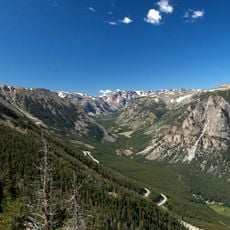
Bad Pass Trail, Archaeological trail in Big Horn County, United States.

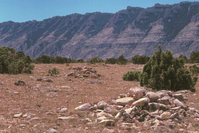
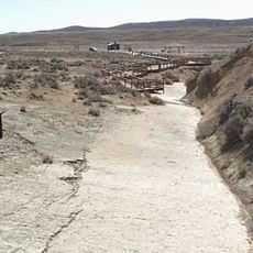
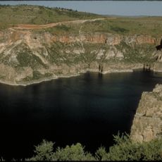
Bad Pass Trail is an archaeological path running along the western edge of Bighorn Canyon, marked by stone cairns and tipi ring structures. The route extends from Shoshone River to Grapevine Creek and shows the physical traces of camps and travel routes.

The trail developed as an important trade route connecting the Bighorn Basin in Wyoming with bison hunting grounds in Montana. People traveled this route across many centuries, gradually marking their passage with stone markers.

The trail displays tipi ring structures on both sides that reveal how Indigenous communities used this landscape across generations. These remains show where people made camp and lived during their journeys through the region.

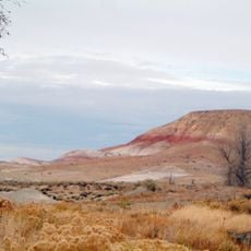
The trail is accessible on foot but requires sturdy footwear due to rocky ground and uneven surfaces throughout. Visitors should bring plenty of water and avoid the area in heavy cloud cover, as navigation becomes difficult.

Each stone in the cairns was added by travelers seeking luck or marking their journey through the canyon. This personal practice over many centuries created a monument built from individual gestures of passage.

The community of curious travelers

AroundUs brings together thousands of curated places, local tips, and hidden gems, enriched daily by 60,000 contributors worldwide.

Start exploring
Location
GPS coordinates
45.00460,-108.27664
Latest update
December 14, 2025 15:01
Around this place
Medicine Wheel/Medicine Mountain National Historic Landmark
United States of America

Medicine Wheel/Medicine Mountain National Historic Landmark

34.3 km
Cloverly Formation
United States of America

Cloverly Formation

20.8 km
Natural Trap Cave
United States of America

Natural Trap Cave

7.5 km
Chief Plenty Coups State Park and Home
United States of America

Chief Plenty Coups State Park and Home

51.6 km
Red Gulch Dinosaur Tracksite
United States of America

Red Gulch Dinosaur Tracksite

69.5 km
Shell Falls
United States of America

Shell Falls

70 km
Bighorn Lake
United States of America

Bighorn Lake

42.1 km
Hyart Theater
United States of America

Hyart Theater

20.6 km
Ewing-Snell Ranch
United States of America

Ewing-Snell Ranch

8.9 km
Cedarvale
United States of America

Cedarvale

11.2 km
Bighorn Ditch Headgate
United States of America

Bighorn Ditch Headgate

43 km
EJZ Bridge over Shoshone River
United States of America

EJZ Bridge over Shoshone River

22.3 km
Lower Shell School House
United States of America

Lower Shell School House

60.3 km
Gebo Barn
United States of America

Gebo Barn

62.9 km
EJE Bridge over Shell Creek
United States of America

EJE Bridge over Shell Creek

64.4 km
United States of America

Ralston Community Clubhouse

55.8 km
Bearcreek Bank
United States of America

Bearcreek Bank

71.5 km
Forsman House
United States of America

Forsman House

59.1 km
Corey House
United States of America

Corey House

59.1 km
Hester E. Suydam Boarding House
United States of America

Hester E. Suydam Boarding House

65.7 km
Glidden House
United States of America

Glidden House

59.1 km
Fromberg Opera House
United States of America

Fromberg Opera House

65.7 km
Fromberg Concrete Arch Bridge
United States of America

Fromberg Concrete Arch Bridge

64.9 km
Raymond Hough House
United States of America

Raymond Hough House

59.5 km
Samuel Greenblatt House
United States of America

Samuel Greenblatt House

65.8 km
Rock Creek
United States of America

Rock Creek

72.2 km
Bighorn Canyon National Recreation Area (parke sa Estados Unidos, Wyoming)
United States of America

Bighorn Canyon National Recreation Area (parke sa Estados Unidos, Wyoming)

14.7 km
Cal S. Taggart Bighorn Canyon Visitor Center
United States of America

Cal S. Taggart Bighorn Canyon Visitor Center

20.2 km
Show the full map
« Bad Pass Trail - Archaeological trail in Big Horn County, United States » is provided by Around Us (aroundus.com). Images and texts are derived from Wikimedia project under a Creative Commons license. You are allowed to copy, distribute, and modify copies of this page, under the conditions set by the license, as long as this note is clearly visible.

Discover hidden gems everywhere you go!

From secret cafés to breathtaking viewpoints, skip the crowded tourist spots and find places that match your style. Our app makes it easy with voice search, smart filtering, route optimization, and insider tips from travelers worldwide. Download now for the complete mobile experience.

Around Us App Screenshot

A unique approach to discovering new places

Le Figaro

All the places worth exploring

France Info

A tailor-made excursion in just a few clicks

20 Minutes

Around Us
Travel Guide & Maps
Download

Send to your phone

QR Code
1

Open the camera app on your mobile.

2

Point at the QR code with your camera. A notification will appear.

3

Tap the notification to open the link.