Enable Location

We need your location to show you interesting places around you

Discover nearby places

Find interesting locations and hidden gems around you

Precise directions

Get accurate directions and distances to places

Your location is never shared with other users. It's only used when you tap the location button.

Shell Falls

Log in to your account

Start exploring — it's free

Trusted by 63,118 travelers worldwide

Continue with Google
Continue with Apple
or

We will send you a code to connect

By continuing, you accept our Terms and Conditions and our Privacy Policy

Check your inbox

We've sent a pincode in your inbox. Please enter the code below.

Shell Falls
Discussion Reviews 1 Photos
3.3k Popularity

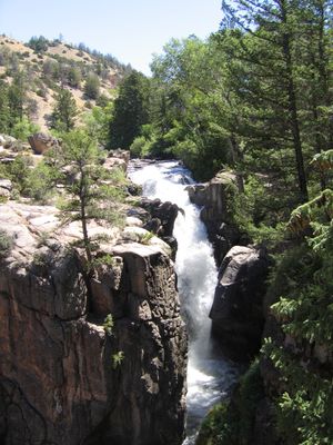
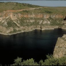
Shell Falls, Waterfall in Big Horn Mountains, Wyoming

Shell Falls is a waterfall in the Big Horn Mountains where water cascades over multiple rock layers at varying speeds. The natural formation was carved where a creek cut through the mountainside along a zone of weakness in the bedrock.

The area around Shell Falls was covered by an ancient ocean millions of years ago, leaving behind fossilized shells and marine remains. These preserved traces are visible in the rock layers and tell the story of a vanished sea that once existed here.

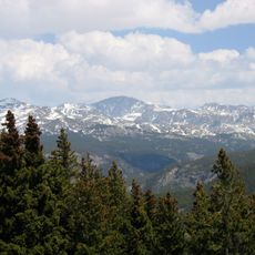
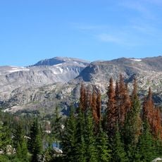
The Shell Falls Interpretive Site educates visitors about the geological processes, water systems, and natural heritage of the Big Horn Mountains region.

A short walking path with several viewpoints lets you see the waterfall from different angles. Wear good footwear because the ground can be slippery, especially when wet from the spray.

Shells gave this waterfall its name and can still be found in the surrounding rocks today. Visitors can spot these ancient fossils in the stone formations and understand how the rock itself preserves traces of the past.

The community of curious travelers

AroundUs brings together thousands of curated places, local tips, and hidden gems, enriched daily by 60,000 contributors worldwide.

Start exploring
Location
Part of
Shell Creek
GPS coordinates
44.58645,-107.61405
Latest update
December 12, 2025 09:03
Around this place
Medicine Wheel/Medicine Mountain National Historic Landmark
United States of America

Medicine Wheel/Medicine Mountain National Historic Landmark

36.1 km
Cloud Peak
United States of America

Cloud Peak

41.7 km
Bomber Mountain
United States of America

Bomber Mountain

43.6 km
Cloud Peak Wilderness
United States of America

Cloud Peak Wilderness

38.8 km
Sheridan Inn
United States of America

Sheridan Inn

57.7 km
Black Tooth Mountain
United States of America

Black Tooth Mountain

40.1 km
Red Gulch Dinosaur Tracksite
United States of America

Red Gulch Dinosaur Tracksite

17.7 km
United States of America

Cloud Peak Glacier

41.8 km
Trail End
United States of America

Trail End

56.6 km
Mount Woolsey
United States of America

Mount Woolsey

40.4 km
United States of America

Bighorn Peak

54.7 km
Sheridan County Courthouse
United States of America

Sheridan County Courthouse

57 km
Lower Shell School House
United States of America

Lower Shell School House

26.4 km
United States of America

Darton Peak

53 km
ECR Kooi Bridge
United States of America

ECR Kooi Bridge

55 km
EJE Bridge over Shell Creek
United States of America

EJE Bridge over Shell Creek

16 km
ECS Bridge over Big Goose Creek
United States of America

ECS Bridge over Big Goose Creek

42.2 km
EJP County Line Bridge
United States of America

EJP County Line Bridge

47.1 km
Holy Name Catholic School
United States of America

Holy Name Catholic School

57.4 km
Rairden Bridge
United States of America

Rairden Bridge

49.8 km
Mount View
United States of America

Mount View

56.5 km
Odd Fellows Hall
United States of America

Odd Fellows Hall

50.4 km
Susan Wissler House
United States of America

Susan Wissler House

42.4 km
St. Peter's Episcopal Church
United States of America

St. Peter's Episcopal Church

57 km
Robinson-Smith House
United States of America

Robinson-Smith House

56.8 km
Bighorn Canyon National Recreation Area (parke sa Estados Unidos, Wyoming)
United States of America

Bighorn Canyon National Recreation Area (parke sa Estados Unidos, Wyoming)

56.5 km
Tyrrel Ranger Station
United States of America

Tyrrel Ranger Station

52.8 km
Tensleep Ranger Station
United States of America

Tensleep Ranger Station

52.8 km
Show the full map
Reviews
Share your experience

No review yet

Discussions
Start a discussion...

No discussion yet

« Shell Falls - Waterfall in Big Horn Mountains, Wyoming » is provided by Around Us (aroundus.com). Images and texts are derived from Wikimedia project under a Creative Commons license. You are allowed to copy, distribute, and modify copies of this page, under the conditions set by the license, as long as this note is clearly visible.

Discover hidden gems everywhere you go!

From secret cafés to breathtaking viewpoints, skip the crowded tourist spots and find places that match your style. Our app makes it easy with voice search, smart filtering, route optimization, and insider tips from travelers worldwide. Download now for the complete mobile experience.

Around Us App Screenshot

A unique approach to discovering new places

Le Figaro

All the places worth exploring

France Info

A tailor-made excursion in just a few clicks

20 Minutes

Around Us
Travel Guide & Maps
Download

Send to your phone

QR Code
1

Open the camera app on your mobile.

2

Point at the QR code with your camera. A notification will appear.

3

Tap the notification to open the link.