Enable Location

We need your location to show you interesting places around you

Discover nearby places

Find interesting locations and hidden gems around you

Precise directions

Get accurate directions and distances to places

Your location is never shared with other users. It's only used when you tap the location button.

Cloud Peak

Log in to your account

Start exploring — it's free

Trusted by 62,898 travelers worldwide

Continue with Google
Continue with Apple
or

We will send you a code to connect

By continuing, you accept our Terms and Conditions and our Privacy Policy

Check your inbox

We've sent a pincode in your inbox. Please enter the code below.

Cloud Peak
Discussion Reviews 1 Photos
13.3k Popularity

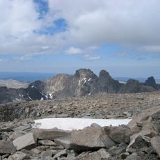
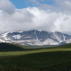
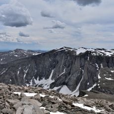
Cloud Peak, Mountain summit in Big Horn County, Wyoming, United States.

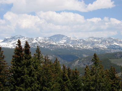
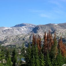
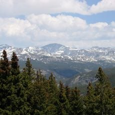
Cloud Peak is a mountain summit in the Bighorn Range of Wyoming that rises to approximately 13,167 feet above sea level. The landscape around it features alpine meadows, mountain lakes, and rocky terrain that characterize this high-elevation wilderness area.

The Bighorn Mountains and this peak served Native American tribes for many centuries as a hunting ground and part of their traditional territory. European settlers began arriving in the region during the 1800s, eventually leading to the creation of protected wilderness areas to preserve the landscape.

The peak draws visitors from across the region who come to test themselves against the mountain and experience high-altitude wilderness firsthand. People speak of the summit as a destination that connects them to the raw landscape and their own limits.

This is a challenging climb requiring good physical fitness and high-altitude hiking experience, especially across the rocky and often snow-covered upper sections. Bring plenty of water and food, start early in the day, and check the weather forecast before heading out since conditions can change rapidly at elevation.

A glacier on the north-facing slope persists at the summit and remains one of the last in the region, slowly releasing water to surrounding streams during dry months. Few visitors realize they are walking near a slowly melting ice field, despite its importance to the local water supply.

The community of curious travelers

AroundUs brings together thousands of curated places, local tips, and hidden gems, enriched daily by 60,000 contributors worldwide.

Start exploring
Location
GPS coordinates
44.38219,-107.17395
Latest update
December 7, 2025 20:40
Around this place
Fort Phil Kearny
United States of America

Fort Phil Kearny

32.3 km
Bomber Mountain
United States of America

Bomber Mountain

1.9 km
Cloud Peak Wilderness
United States of America

Cloud Peak Wilderness

2.9 km
Black Tooth Mountain
United States of America

Black Tooth Mountain

2.4 km
Shell Falls
United States of America

Shell Falls

41.7 km
Jim Gatchell Memorial Museum
United States of America

Jim Gatchell Memorial Museum

37.9 km
TA Ranch Historic District
United States of America

TA Ranch Historic District

47.5 km
United States of America

Cloud Peak Glacier

647 m
Trail End
United States of America

Trail End

49.5 km
Mount Woolsey
United States of America

Mount Woolsey

2.1 km
United States of America

Bighorn Peak

15.2 km
Sheridan County Courthouse
United States of America

Sheridan County Courthouse

49.1 km
Holland House
United States of America

Holland House

38 km
United States of America

Darton Peak

12.9 km
Union Congregational Church and Parsonage
United States of America

Union Congregational Church and Parsonage

38.2 km
Main Street Historic District
United States of America

Main Street Historic District

38.1 km
EDL Peloux Bridge
United States of America

EDL Peloux Bridge

41.4 km
ECS Bridge over Big Goose Creek
United States of America

ECS Bridge over Big Goose Creek

40.3 km
James T. Saban Lookout
United States of America

James T. Saban Lookout

26 km
EJP County Line Bridge
United States of America

EJP County Line Bridge

47.2 km
Johnson County Courthouse
United States of America

Johnson County Courthouse

38 km
Holy Name Catholic School
United States of America

Holy Name Catholic School

49.3 km
Mount View
United States of America

Mount View

48.6 km
Odd Fellows Hall
United States of America

Odd Fellows Hall

36.1 km
St. Peter's Episcopal Church
United States of America

St. Peter's Episcopal Church

49.3 km
Robinson-Smith House
United States of America

Robinson-Smith House

48.8 km
Tyrrel Ranger Station
United States of America

Tyrrel Ranger Station

22.3 km
Tensleep Ranger Station
United States of America

Tensleep Ranger Station

22.3 km
Show the full map
« Cloud Peak - Mountain summit in Big Horn County, Wyoming, United States » is provided by Around Us (aroundus.com). Images and texts are derived from Wikimedia project under a Creative Commons license. You are allowed to copy, distribute, and modify copies of this page, under the conditions set by the license, as long as this note is clearly visible.

Discover hidden gems everywhere you go!

From secret cafés to breathtaking viewpoints, skip the crowded tourist spots and find places that match your style. Our app makes it easy with voice search, smart filtering, route optimization, and insider tips from travelers worldwide. Download now for the complete mobile experience.

Around Us App Screenshot

A unique approach to discovering new places

Le Figaro

All the places worth exploring

France Info

A tailor-made excursion in just a few clicks

20 Minutes

Around Us
Travel Guide & Maps
Download

Send to your phone

QR Code
1

Open the camera app on your mobile.

2

Point at the QR code with your camera. A notification will appear.

3

Tap the notification to open the link.