Enable Location

We need your location to show you interesting places around you

Discover nearby places

Find interesting locations and hidden gems around you

Precise directions

Get accurate directions and distances to places

Your location is never shared with other users. It's only used when you tap the location button.

Big Baldy Mountain

Log in to your account

Start exploring — it's free

Trusted by 63,013 travelers worldwide

Continue with Google
Continue with Apple
or

We will send you a code to connect

By continuing, you accept our Terms and Conditions and our Privacy Policy

Check your inbox

We've sent a pincode in your inbox. Please enter the code below.

Big Baldy Mountain
Discussion Reviews 1 Photos
2.3k Popularity

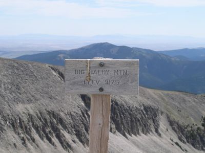
Big Baldy Mountain, Mountain summit in Judith Basin County, Montana, United States.

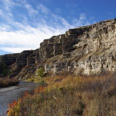
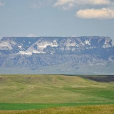
Big Baldy Mountain is a summit in the Little Belt Mountain Range of central Montana rising to 9,175 feet. The peak features a distinctive bare, tree-free crown that stands above surrounding forest and alpine meadows.

The mountain formed through magmatic activity during the Rocky Mountains creation, when underground magma intrusions shaped the rock structure. These volcanic processes occurred without reaching the surface, leaving behind the distinctive geological features visible today.

The mountain attracts geologists and researchers who study its distinctive crater formations and potential volcanic origins through detailed field observations.

Reaching the summit requires driving on forest service roads followed by a hiking trek that gains considerable elevation over several hours. Weather conditions at altitude can change rapidly, so proper preparation and sturdy gear are important for the outing.

Vegetation stops well below the summit, creating the characteristic bald appearance that inspired the mountain's name. This natural tree line boundary resulted from the peak's altitude and exposure to wind and harsh alpine conditions.

The community of curious travelers

AroundUs brings together thousands of curated places, local tips, and hidden gems, enriched daily by 60,000 contributors worldwide.

Start exploring
Location
GPS coordinates
46.96857,-110.60633
Latest update
December 13, 2025 12:22
Around this place
Great Falls
United States of America

Great Falls

77.5 km
Black Eagle Dam
United States of America

Black Eagle Dam

78.9 km
C. M. Russell Museum Complex
United States of America

C. M. Russell Museum Complex

79.2 km
Great Falls
United States of America

Great Falls

77.4 km
490th Missile Squadron
United States of America

490th Missile Squadron

74.1 km
Rainbow Falls
United States of America

Rainbow Falls

77.5 km
Rainbow Dam
United States of America

Rainbow Dam

77.5 km
Great Falls Portage
United States of America

Great Falls Portage

75 km
Sluice Boxes State Park
United States of America

Sluice Boxes State Park

34 km
Great Falls Air Defense Sector
United States of America

Great Falls Air Defense Sector

74.9 km
Paris Gibson Square Museum of Art
United States of America

Paris Gibson Square Museum of Art

78.7 km
St. Ann's Cathedral
United States of America

St. Ann's Cathedral

79.5 km
Byron R. Sherman House
United States of America

Byron R. Sherman House

51.6 km
Cascade County Courthouse
United States of America

Cascade County Courthouse

79.7 km
Masonic Temple
United States of America

Masonic Temple

79.1 km
Judith River Ranger Station
United States of America

Judith River Ranger Station

27.6 km
Parberry Block East
United States of America

Parberry Block East

52 km
Lee M. Ford House
United States of America

Lee M. Ford House

79.9 km
Margaret Block
United States of America

Margaret Block

79.5 km
Electric City Water Park
United States of America

Electric City Water Park

79.9 km
Our Savior's Lutheran Church (Great Falls)
United States of America

Our Savior's Lutheran Church (Great Falls)

78.7 km
Charles M Bair Family Museum
United States of America

Charles M Bair Family Museum

60.1 km
First English Evangelical Lutheran Church (Great Falls)
United States of America

First English Evangelical Lutheran Church (Great Falls)

79.4 km
Great Falls Central Business Historic District
United States of America

Great Falls Central Business Historic District

79.5 km
Smith River Valley Historical Marker
United States of America

Smith River Valley Historical Marker

63.9 km
Square Butte
United States of America

Square Butte

62.7 km
First Presbyterian Church (Great Falls)
United States of America

First Presbyterian Church (Great Falls)

78.7 km
Trinity Lutheran Church (Great Falls)
United States of America

Trinity Lutheran Church (Great Falls)

78.8 km
Show the full map
Reviews
Share your experience

No review yet

Discussions
Start a discussion...

No discussion yet

« Big Baldy Mountain - Mountain summit in Judith Basin County, Montana, United States » is provided by Around Us (aroundus.com). Images and texts are derived from Wikimedia project under a Creative Commons license. You are allowed to copy, distribute, and modify copies of this page, under the conditions set by the license, as long as this note is clearly visible.

Discover hidden gems everywhere you go!

From secret cafés to breathtaking viewpoints, skip the crowded tourist spots and find places that match your style. Our app makes it easy with voice search, smart filtering, route optimization, and insider tips from travelers worldwide. Download now for the complete mobile experience.

Around Us App Screenshot

A unique approach to discovering new places

Le Figaro

All the places worth exploring

France Info

A tailor-made excursion in just a few clicks

20 Minutes

Around Us
Travel Guide & Maps
Download

Send to your phone

QR Code
1

Open the camera app on your mobile.

2

Point at the QR code with your camera. A notification will appear.

3

Tap the notification to open the link.