Angostura Dam

Log in to your account

AroundUs is a community-driven map of interesting places, built by curious explorers like you. It grows with every review, story, and photo you share.
Connect to save your favorite spots, contribute locations, and create personalized routes.
By continuing, you accept our Terms and Conditions and our Privacy Policy

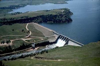
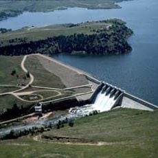
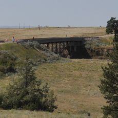
Angostura Dam, Embankment dam in Fall River County, United States

The Angostura Dam spans across the Cheyenne River with an earth-fill embankment and concrete spillway section measuring 193 feet in height and 2,030 feet in length.

Construction of the dam took place between 1946 and 1949 as part of the Pick-Sloan Missouri Basin Program in response to severe drought conditions affecting farmers in the 1930s.

The surrounding Angostura Recreation Area, managed by South Dakota Department of Game, Fish, and Parks, provides opportunities for fishing, boating, and outdoor recreational activities.

The dam maintains irrigation services for 12,218 acres of agricultural land through the Angostura Canal, which can distribute water at a rate of 290 cubic feet per second.

The reservoir created by the dam extends over 36 miles of shoreline and contains multiple fish species including walleye, smallmouth bass, and crappie in its 4,706 acres of water.

Location: Fall River County

GPS coordinates: 43.34280,-103.43600

Latest update: March 13, 2025 11:36

Around this place
Show the full map
Custer State Park
United States of America

Custer State Park

44.9 km
Mammoth Site, Hot Springs
United States of America

Mammoth Site, Hot Springs

9.9 km
Toadstool Geologic Park
United States of America

Toadstool Geologic Park

54.3 km
Angostura Reservoir
United States of America

Angostura Reservoir

4.1 km
Black Hills Playhouse
United States of America

Black Hills Playhouse

51.6 km
1881 Courthouse Museum
United States of America

1881 Courthouse Museum

49 km
Governor Leslie Jensen House
United States of America

Governor Leslie Jensen House

10 km
Pig Tail Bridge
United States of America

Pig Tail Bridge

29.1 km
State Soldiers Home Barn
United States of America

State Soldiers Home Barn

11.6 km
Jewel Cave
United States of America

Jewel Cave

53.5 km
Wind Cave
United States of America

Wind Cave

24.2 km
Peter Norbeck Summer House
United States of America

Peter Norbeck Summer House

51.1 km
Arthur and Ellen Colgan House
United States of America

Arthur and Ellen Colgan House

32 km
Wind Cave National Park Administrative and Utility Area Historic District
United States of America

Wind Cave National Park Administrative and Utility Area Historic District

24 km
Chilson Bridge
United States of America

Chilson Bridge

24.2 km
Phillip Wesch House
United States of America

Phillip Wesch House

11.4 km
Custer County Courthouse
United States of America

Custer County Courthouse

49 km
Beaver Creek Rockshelter
United States of America

Beaver Creek Rockshelter

26.7 km
Beaver Creek Bridge
United States of America

Beaver Creek Bridge

27.2 km
Mount Coolidge Lookout Tower
United States of America

Mount Coolidge Lookout Tower

44.9 km
Peter Norbeck Outdoor Education Center
United States of America

Peter Norbeck Outdoor Education Center

47.3 km
Rankin Ridge Lookout Tower
United States of America

Rankin Ridge Lookout Tower

31.7 km
Historic Trail and Cave Entrance
United States of America

Historic Trail and Cave Entrance

54.4 km
Pioneer Museum
United States of America

Pioneer Museum

10.6 km
Wind Cave Visitor Center
United States of America

Wind Cave Visitor Center

24 km
Elk Mountain Campground
United States of America

Elk Mountain Campground

25.2 km
Jewel Cave Visitor Center
United States of America

Jewel Cave Visitor Center

53.5 km
Warbonnet Battlefield Monument
United States of America

Warbonnet Battlefield Monument

52 km
Show the full map

Reviews

Visited this place? Tap the stars to rate it and share your experience / photos with the community! Try now! You can cancel it anytime.

« Angostura Dam - Embankment dam in Fall River County, United States » is provided by Around Us (aroundus.com). Images and texts are derived from Wikimedia project under a Creative Commons license. You are allowed to copy, distribute, and modify copies of this page, under the conditions set by the license, as long as this note is clearly visible.

Discover hidden gems everywhere you go!

From secret cafés to breathtaking viewpoints, skip the crowded tourist spots and find places that match your style. Our app makes it easy with voice search, smart filtering, route optimization, and insider tips from travelers worldwide. Download now for the complete mobile experience.

Around Us App Screenshot

A unique approach to discovering new places

Le Figaro

All the places worth exploring

France Info

A tailor-made excursion in just a few clicks

20 Minutes