Enable Location

We need your location to show you interesting places around you

Discover nearby places

Find interesting locations and hidden gems around you

Precise directions

Get accurate directions and distances to places

Your location is never shared with other users. It's only used when you tap the location button.

Angostura Reservoir

Log in to your account

Start exploring — it's free

Trusted by 62,473 travelers worldwide

Continue with Google
Continue with Apple
or

We will send you a code to connect

By continuing, you accept our Terms and Conditions and our Privacy Policy

Check your inbox

We've sent a pincode in your inbox. Please enter the code below.

Angostura Reservoir

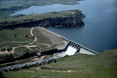
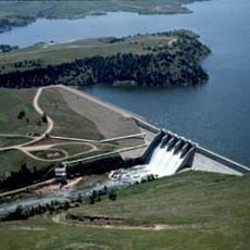
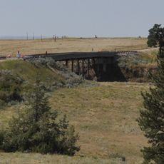
Angostura Reservoir, body of water

Angostura Reservoir is a large body of water in South Dakota built in 1949 across the Cheyenne River by the Bureau of Reclamation. The water spans a vast area with approximately 42 miles of shoreline and an average depth of about 95 feet (29 meters), reaching up to 245 feet (75 meters) when full.

Angostura Reservoir was built in 1949 as part of the Pick-Sloan Missouri Basin Program to manage water resources and support irrigation in the region. The dam, constructed by the Bureau of Reclamation, controls the Cheyenne River's flow for agricultural and water supply needs.

The name Angostura comes from Spanish and means 'narrows,' referring to the narrower sections of the water body. Today, this place brings people together to relax, fish, and enjoy outdoor recreation in a shared natural setting.

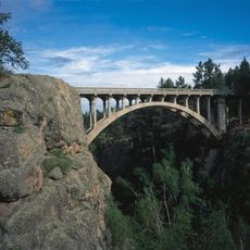
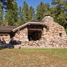
The reservoir is located about 10 miles southeast of Hot Springs, South Dakota, off U.S. Highway 385-18 and is open year-round with an entrance fee required. Well-marked roads, several campgrounds with more than 170 campsites, boat ramps, and accessible facilities including a visitor center make planning and navigation straightforward.

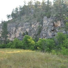
Angostura Reservoir is a crucial stopover for migratory waterbirds that follow the eastern edge of the Black Hills during their seasonal journeys. Birdwatchers find the undeveloped western shoreline offers the best vantage points to observe these traveling birds.

The community of curious travelers

AroundUs brings together thousands of curated places, local tips, and hidden gems, enriched daily by 60,000 contributors worldwide.

Start exploring
Location
GPS coordinates
43.30582,-103.43425
Latest update
February 7, 2026 11:00
Around this place
Custer State Park
United States of America

Custer State Park

49 km
Mammoth Site, Hot Springs
United States of America

Mammoth Site, Hot Springs

13.8 km
Toadstool Geologic Park
United States of America

Toadstool Geologic Park

50.4 km
Hudson-Meng Bison Kill
United States of America

Hudson-Meng Bison Kill

54.4 km
Black Hills Playhouse
United States of America

Black Hills Playhouse

55.7 km
Angostura Dam
United States of America

Angostura Dam

4.1 km
1881 Courthouse Museum
United States of America

1881 Courthouse Museum

53 km
Governor Leslie Jensen House
United States of America

Governor Leslie Jensen House

14.1 km
Dawes County Courthouse
United States of America

Dawes County Courthouse

53.4 km
Pig Tail Bridge
United States of America

Pig Tail Bridge

33.2 km
State Soldiers Home Barn
United States of America

State Soldiers Home Barn

15.4 km
Jewel Cave
United States of America

Jewel Cave

56.9 km
Wind Cave
United States of America

Wind Cave

28.3 km
Peter Norbeck Summer House
United States of America

Peter Norbeck Summer House

55.3 km
Arthur and Ellen Colgan House
United States of America

Arthur and Ellen Colgan House

31.8 km
Wind Cave National Park Administrative and Utility Area Historic District
United States of America

Wind Cave National Park Administrative and Utility Area Historic District

28.1 km
Chilson Bridge
United States of America

Chilson Bridge

24.4 km
Phillip Wesch House
United States of America

Phillip Wesch House

15.3 km
Custer County Courthouse
United States of America

Custer County Courthouse

53 km
Beaver Creek Rockshelter
United States of America

Beaver Creek Rockshelter

30.8 km
Beaver Creek Bridge
United States of America

Beaver Creek Bridge

31.3 km
Mount Coolidge Lookout Tower
United States of America

Mount Coolidge Lookout Tower

49 km
Peter Norbeck Outdoor Education Center
United States of America

Peter Norbeck Outdoor Education Center

51.4 km
Rankin Ridge Lookout Tower
United States of America

Rankin Ridge Lookout Tower

35.8 km
Pioneer Museum
United States of America

Pioneer Museum

14.6 km
Wind Cave Visitor Center
United States of America

Wind Cave Visitor Center

28.1 km
Elk Mountain Campground
United States of America

Elk Mountain Campground

29.3 km
Warbonnet Battlefield Monument
United States of America

Warbonnet Battlefield Monument

48.5 km
Show the full map
« Angostura Reservoir - body of water » is provided by Around Us (aroundus.com). Images and texts are derived from Wikimedia project under a Creative Commons license. You are allowed to copy, distribute, and modify copies of this page, under the conditions set by the license, as long as this note is clearly visible.

Discover hidden gems everywhere you go!

From secret cafés to breathtaking viewpoints, skip the crowded tourist spots and find places that match your style. Our app makes it easy with voice search, smart filtering, route optimization, and insider tips from travelers worldwide. Download now for the complete mobile experience.

Around Us App Screenshot

A unique approach to discovering new places

Le Figaro

All the places worth exploring

France Info

A tailor-made excursion in just a few clicks

20 Minutes

Around Us
Travel Guide & Maps
Download

Send to your phone

QR Code
1

Open the camera app on your mobile.

2

Point at the QR code with your camera. A notification will appear.

3

Tap the notification to open the link.