Enable Location

We need your location to show you interesting places around you

Discover nearby places

Find interesting locations and hidden gems around you

Precise directions

Get accurate directions and distances to places

Your location is never shared with other users. It's only used when you tap the location button.

Bearpaw Shale

Log in to your account

Start exploring — it's free

Trusted by 62,992 travelers worldwide

Continue with Google
Continue with Apple
or

We will send you a code to connect

By continuing, you accept our Terms and Conditions and our Privacy Policy

Check your inbox

We've sent a pincode in your inbox. Please enter the code below.

Bearpaw Shale
Discussion Reviews 1 Photos
11.5k Popularity

Bearpaw Shale, Late Cretaceous geological formation in Montana and Wyoming, United States.

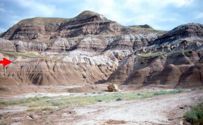
The Bearpaw Shale is a geological formation composed of dark gray clay and limestone concretions found across Montana and Wyoming. These rock layers formed within an ancient seaway and contain thin beds of bentonite mixed throughout the sequence.

This formation developed between 75 and 72 million years ago when a shallow seaway covered parts of central North America. The deposits accumulated as sediment gradually settled on the ancient seafloor.

Geological studies of the Bearpaw Shale contribute to research programs focused on understanding sedimentary basins and marine deposits in North America.

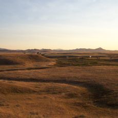
Access to this formation can be challenging as its layers appear in remote areas with rolling terrain. The best viewing occurs where natural erosion or roadcuts expose the rock sequences.

The layers preserve remains of ancient marine animals such as ammonites and large swimming reptiles from the Cretaceous era. These fossils reveal the types of creatures that lived in this prehistoric seaway.

The community of curious travelers

AroundUs brings together thousands of curated places, local tips, and hidden gems, enriched daily by 60,000 contributors worldwide.

Start exploring
Location
Location
Made from material
shale, claystone
GPS coordinates
48.25000,-109.50000
Latest update
December 8, 2025 13:40
Around this place
Dinosaur Park Formation
Canada

Dinosaur Park Formation

124.7 km
Fort Assinniboine
United States of America

Fort Assinniboine

35.3 km
Eye of the Needle
United States of America

Eye of the Needle

56.3 km
Too Close For Comfort Site
United States of America

Too Close For Comfort Site

38.1 km
Fred Robinson Bridge
United States of America

Fred Robinson Bridge

91.9 km
Great Plains Dinosaur Museum and Field Station
United States of America

Great Plains Dinosaur Museum and Field Station

121.5 km
Fort Benton Historic District
United States of America

Fort Benton Historic District

99.4 km
Skyland Camp-Bowman Lake Ranger Station
United States of America

Skyland Camp-Bowman Lake Ranger Station

115.5 km
Fort Benton Bridge
United States of America

Fort Benton Bridge

98.9 km
Havre Residential Historic District
United States of America

Havre Residential Historic District

35.5 km
Dave's Texaco
United States of America

Dave's Texaco

43 km
Judith Landing Historic District
United States of America

Judith Landing Historic District

57.8 km
H. Earl Clack House
United States of America

H. Earl Clack House

35.8 km
First State Bank of Chester
United States of America

First State Bank of Chester

112.2 km
Young–Almas House
United States of America

Young–Almas House

40.2 km
Phillips County Carnegie Library
United States of America

Phillips County Carnegie Library

120.9 km
Carnegie Public Library
United States of America

Carnegie Public Library

35.8 km
Chouteau County Courthouse
United States of America

Chouteau County Courthouse

99.2 km
Masonic Building
United States of America

Masonic Building

98.9 km
Ervin Homestead-Gist Bottom Historic District
United States of America

Ervin Homestead-Gist Bottom Historic District

61.5 km
Fort Benton Engine House
United States of America

Fort Benton Engine House

98.9 km
Lewistown Silk Stocking District
United States of America

Lewistown Silk Stocking District

131.9 km
Havre Beneath the Streets
United States of America

Havre Beneath the Streets

36.3 km
Old Fort Benton
United States of America

Old Fort Benton

98.9 km
Grand Theater
United States of America

Grand Theater

61.2 km
Montana Agricultural Center
United States of America

Montana Agricultural Center

98.9 km
Square Butte
United States of America

Square Butte

102.5 km
Chief Joseph Battleground of the Bear's Paw
United States of America

Chief Joseph Battleground of the Bear's Paw

26 km
Show the full map
Reviews
Share your experience

No review yet

Discussions
Start a discussion...

No discussion yet

« Bearpaw Shale - Late Cretaceous geological formation in Montana and Wyoming, United States » is provided by Around Us (aroundus.com). Images and texts are derived from Wikimedia project under a Creative Commons license. You are allowed to copy, distribute, and modify copies of this page, under the conditions set by the license, as long as this note is clearly visible.

Discover hidden gems everywhere you go!

From secret cafés to breathtaking viewpoints, skip the crowded tourist spots and find places that match your style. Our app makes it easy with voice search, smart filtering, route optimization, and insider tips from travelers worldwide. Download now for the complete mobile experience.

Around Us App Screenshot

A unique approach to discovering new places

Le Figaro

All the places worth exploring

France Info

A tailor-made excursion in just a few clicks

20 Minutes

Around Us
Travel Guide & Maps
Download

Send to your phone

QR Code
1

Open the camera app on your mobile.

2

Point at the QR code with your camera. A notification will appear.

3

Tap the notification to open the link.