Custer County

Log in to your account

AroundUs is a community-driven map of interesting places, built by curious explorers like you. It grows with every review, story, and photo you share.
Connect to save your favorite spots, contribute locations, and create personalized routes.
By continuing, you accept our Terms and Conditions and our Privacy Policy
Add to collection
Map
Suggest a change
Share

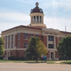
Custer County, County in western Oklahoma, United States.

Custer County is an administrative division in western Oklahoma covering rolling plains with scattered communities and agricultural lands. Interstate 40 and several state highways run through the territory, connecting its towns and rural areas.

The county was established in 1892 during Oklahoma's third land run, when settlers claimed new parcels of territory. It was named after General George Armstrong Custer four years later.

The county's economy and daily rhythms center on ranching and farming, with small towns serving as gathering places for local residents and families.

Roads are generally well-maintained, with Interstate 40 serving as the main route through the county. Keep in mind that rural areas have fewer services and distances between towns are considerable.

The historic Beale Wagon Road, built in 1858, passed through what is now the county while connecting Fort Smith to Los Angeles. This old trading route reflects the region's strategic position during early western expansion.

Location: Oklahoma

Inception: April 19, 1892

Capital city: Arapaho

Shares border with: Dewey County, Washita County, Blaine County, Caddo County, Beckham County, Roger Mills County

Website: http://custer.okcounties.org

GPS coordinates: 35.64000,-99.01000

Latest update: December 7, 2025 20:45

Photos
Around this place
Foss Reservoir
United States of America

Foss Reservoir

20.8 km
Roman Nose State Park
United States of America

Roman Nose State Park

62.3 km
Fort Reno
United States of America

Fort Reno

88.7 km
Gloss Mountain State Park
United States of America

Gloss Mountain State Park

89.7 km
Stafford Air & Space Museum
United States of America

Stafford Air & Space Museum

32.6 km
Fort Cobb
United States of America

Fort Cobb

80 km
Quartz Mountain Nature Park
United States of America

Quartz Mountain Nature Park

81.3 km
Red Rock Canyon State Park
United States of America

Red Rock Canyon State Park

63.3 km
Rock Mary
United States of America

Rock Mary

56.6 km
Provine Service Station
United States of America

Provine Service Station

39.9 km
Washita National Wildlife Refuge
United States of America

Washita National Wildlife Refuge

22.1 km
Oklahoma Route 66 Museum
United States of America

Oklahoma Route 66 Museum

15 km
Storm House
United States of America

Storm House

44.5 km
Washita County Courthouse
United States of America

Washita County Courthouse

38.9 km
Beckham County Courthouse
United States of America

Beckham County Courthouse

68.8 km
Sayre Champlin Service Station
United States of America

Sayre Champlin Service Station

69.2 km
United States Post Office Watonga
United States of America

United States Post Office Watonga

58.6 km
Sayre Downtown Historic District
United States of America

Sayre Downtown Historic District

69 km
Blaine County Courthouse
United States of America

Blaine County Courthouse

58.8 km
Cordell Carnegie Public Library
United States of America

Cordell Carnegie Public Library

38.7 km
National Rt 66 and Transportation Museum
United States of America

National Rt 66 and Transportation Museum

46.3 km
Canute Service Station
United States of America

Canute Service Station

34.5 km
J. W. Danner House
United States of America

J. W. Danner House

68.8 km
Ellis County Courthouse
United States of America

Ellis County Courthouse

87.9 km
Hobart City Hall
United States of America

Hobart City Hall

68.8 km
Historic Fort Reno Visitors Center
United States of America

Historic Fort Reno Visitors Center

88.8 km
Liberty Theatre
United States of America

Liberty Theatre

69.9 km
National Route 66 Museum
United States of America

National Route 66 Museum

46.3 km
Show the full map
Reviews

Visited this place? Tap the stars to rate it and share your experience / photos with the community! Try now! You can cancel it anytime.

Administrative divisions
« Custer County - County in western Oklahoma, United States » is provided by Around Us (aroundus.com). Images and texts are derived from Wikimedia project under a Creative Commons license. You are allowed to copy, distribute, and modify copies of this page, under the conditions set by the license, as long as this note is clearly visible.

Discover hidden gems everywhere you go!

From secret cafés to breathtaking viewpoints, skip the crowded tourist spots and find places that match your style. Our app makes it easy with voice search, smart filtering, route optimization, and insider tips from travelers worldwide. Download now for the complete mobile experience.

Around Us App Screenshot

A unique approach to discovering new places

Le Figaro

All the places worth exploring

France Info

A tailor-made excursion in just a few clicks

20 Minutes