Chest opened
+${chestReward.xp} XP
Explorer
NOUVEAU ×${chestReward.collectible.quantity}
tapez pour fermer
Chest locked

Open chests in the app

Around Us is built for your phone — chests unlock when you walk, explore and capture nearby places.

Enable Location

We need your location to show you interesting places around you

Discover nearby places

Find interesting locations and hidden gems around you

Precise directions

Get accurate directions and distances to places

Your location is never shared with other users. It's only used when you tap the location button.

Log in to your account

Start exploring — it's free

Trusted by 72,878 travelers worldwide

Continue with Google
Continue with Apple
or

We will send you a code to connect

By continuing, you accept our Terms and Conditions and our Privacy Policy

Check your inbox

We've sent a pincode in your inbox. Please enter the code below.

Discussion Reviews Photo
1.4k Popularity

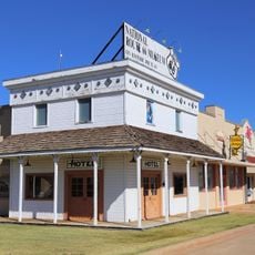
Day County, Former territorial county in western Oklahoma Territory, United States.

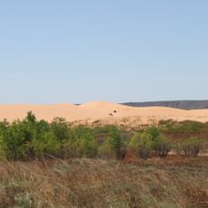
Day County was a former territorial county in western Oklahoma Territory that stretched along the Texas border. The Canadian River ran through the center of the area, creating a landscape of river valleys and rolling hills.

The area was established as County E in 1891 and remained as a separate territory until 1907. Oklahoma's entry into statehood ended the county's existence, as it was divided between the neighboring Ellis and Roger Mills counties.

The county experienced conflicts between cattle ranchers and small farmers regarding land usage, particularly concerning the regulation of unfenced grazing territories.

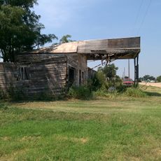
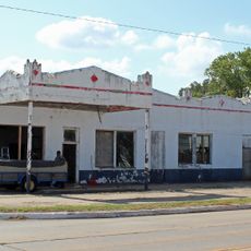
The settlement moved in 1893 from Ioland to Grand, where officials built an administrative building to manage the county's affairs. Today, visitors find no surviving structures from this period, as the main building was destroyed by fire in 1896.

The name came from Charles Day, a contractor who built the first administrative building in Ioland. His role in establishing the settlement was honored through the county's naming during his lifetime.

The community of curious travelers

AroundUs brings together thousands of curated places, local tips, and hidden gems, enriched daily by 60,000 contributors worldwide.

Start exploring
GPS coordinates
36.00000,-99.70000
Latest update
March 5, 2026 18:17
Around this place
Little Sahara State Park
United States of America

Little Sahara State Park

94.4 km
Foss Reservoir
United States of America

Foss Reservoir

64.6 km
Alabaster Caverns State Park
United States of America

Alabaster Caverns State Park

92.2 km
Boiling Springs State Park
United States of America

Boiling Springs State Park

62.2 km
Fort Supply
United States of America

Fort Supply

65.4 km
Fort Elliott
United States of America

Fort Elliott

86.9 km
Magnolia Service Station
United States of America

Magnolia Service Station

90.9 km
Washita National Wildlife Refuge
United States of America

Washita National Wildlife Refuge

59.6 km
Oklahoma Route 66 Museum
United States of America

Oklahoma Route 66 Museum

84.7 km
Storm House
United States of America

Storm House

70.5 km
Beckham County Courthouse
United States of America

Beckham County Courthouse

79.1 km
L. L. Stine House
United States of America

L. L. Stine House

55.9 km
Route 66 Bridge over the Chicago, Rock Island and Gulf Railroad
United States of America

Route 66 Bridge over the Chicago, Rock Island and Gulf Railroad

93.6 km
Sayre Champlin Service Station
United States of America

Sayre Champlin Service Station

79.1 km
Sayre Downtown Historic District
United States of America

Sayre Downtown Historic District

79.1 km
National Rt 66 and Transportation Museum
United States of America

National Rt 66 and Transportation Museum

69.6 km
Canute Service Station
United States of America

Canute Service Station

74.7 km
J. W. Danner House
United States of America

J. W. Danner House

78.7 km
Roberts County Courthouse
United States of America

Roberts County Courthouse

91.1 km
Lipscomb County Courthouse
United States of America

Lipscomb County Courthouse

57.5 km
Ellis County Courthouse
United States of America

Ellis County Courthouse

16.3 km
Harper County Courthouse
United States of America

Harper County Courthouse

93 km
Palace Theatre
United States of America

Palace Theatre

62.4 km
National Route 66 Museum
United States of America

National Route 66 Museum

69.6 km
Boiling Springs State Park Pool Bathhouse
United States of America

Boiling Springs State Park Pool Bathhouse

61.9 km
Shattuck Windmill Museum
United States of America

Shattuck Windmill Museum

33.8 km
Roberts County Museum
United States of America

Roberts County Museum

91.3 km
Canadian River Wagon Bridge
United States of America

Canadian River Wagon Bridge

61.1 km
Show the full map
Reviews
Share your experience

No review yet

Discussions
Start a discussion...

No discussion yet

« Day County - Former territorial county in western Oklahoma Territory, United States » is provided by Around Us (aroundus.com). Images and texts are derived from Wikimedia project under a Creative Commons license. You are allowed to copy, distribute, and modify copies of this page, under the conditions set by the license, as long as this note is clearly visible.

Discover hidden gems everywhere you go!

From secret cafés to breathtaking viewpoints, skip the crowded tourist spots and find places that match your style. Our app makes it easy with voice search, smart filtering, route optimization, and insider tips from travelers worldwide. Download now for the complete mobile experience.

Around Us App Screenshot

A unique approach to discovering new places

Le Figaro

All the places worth exploring

France Info

A tailor-made excursion in just a few clicks

20 Minutes

Around Us
Travel Guide & Maps
Download

Send to your phone

QR Code
1

Open the camera app on your mobile.

2

Point at the QR code with your camera. A notification will appear.

3

Tap the notification to open the link.