Chest opened
+${chestReward.xp} XP
Explorer
NOUVEAU ×${chestReward.collectible.quantity}
tapez pour fermer
Chest locked

Open chests in the app

Around Us is built for your phone — chests unlock when you walk, explore and capture nearby places.

Enable Location

We need your location to show you interesting places around you

Discover nearby places

Find interesting locations and hidden gems around you

Precise directions

Get accurate directions and distances to places

Your location is never shared with other users. It's only used when you tap the location button.

Cavanal Hill

Log in to your account

Start exploring — it's free

Trusted by 72,888 travelers worldwide

Continue with Google
Continue with Apple
or

We will send you a code to connect

By continuing, you accept our Terms and Conditions and our Privacy Policy

Check your inbox

We've sent a pincode in your inbox. Please enter the code below.

Cavanal Hill
Discussion Reviews 1 Photos
16.1k Popularity

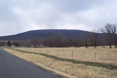
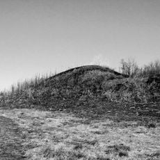
Cavanal Hill, Mountain in LeFlore County, United States.

Cavanal Hill is a mountain in LeFlore County with an elevation exceeding 2,000 feet and a limestone interior containing multiple natural caves. Its slopes offer expansive views across the surrounding landscape.

French fur trappers established camps at the mountain's base during the 1700s, leading to the founding of the nearby settlement of Poteau. These early European activities shaped the region's settlement history.

The mountain served as a boundary marker between different districts within the Choctaw Nation's territory. The area around it reflects the long connection between the land and the people who inhabited this region.

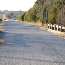
A paved road winds about 4.5 miles to the summit, where a pavilion offers space to rest and enjoy the surroundings. The location works well for hiking and sightseeing throughout the year.

A sign at the mountain's base playfully claims it is the tallest hill in the world, despite its actual elevation being considerably higher than the number stated. This tongue-in-cheek assertion has become a well-known local landmark over the years.

The community of curious travelers

AroundUs brings together thousands of curated places, local tips, and hidden gems, enriched daily by 60,000 contributors worldwide.

Start exploring
Location
GPS coordinates
35.07083,-94.67944
Latest update
December 7, 2025 19:28
Around this place
Spiro Mounds
United States of America

Spiro Mounds

28.7 km
Robert S. Kerr Reservoir
United States of America

Robert S. Kerr Reservoir

34.9 km
Fort Smith National Cemetery
United States of America

Fort Smith National Cemetery

41.6 km
Lake Wister
United States of America

Lake Wister

15.7 km
Jenson Tunnel
United States of America

Jenson Tunnel

27 km
Peter Conser House
United States of America

Peter Conser House

25.8 km
Lake Wister State Park
United States of America

Lake Wister State Park

18.9 km
W. D. Mayo Lock and Dam
United States of America

W. D. Mayo Lock and Dam

29.4 km
James E. Reynolds House
United States of America

James E. Reynolds House

15.4 km
Hartford Water Tower
United States of America

Hartford Water Tower

28 km
Maumelle Ordnance Works Locomotive 1
United States of America

Maumelle Ordnance Works Locomotive 1

41.7 km
Jones Memorial Methodist Church
United States of America

Jones Memorial Methodist Church

28.1 km
Greenwood Presbyterian Church
United States of America

Greenwood Presbyterian Church

41.7 km
Trahern's Station
United States of America

Trahern's Station

12.5 km
Terry House
United States of America

Terry House

5 km
LeFlore County Courthouse
United States of America

LeFlore County Courthouse

5.4 km
Hackett Creek Bridge
United States of America

Hackett Creek Bridge

27.7 km
United States of America

Summerfield School

20.3 km
Oscar Chambers House
United States of America

Oscar Chambers House

40.5 km
Williams School
United States of America

Williams School

15.9 km
Tucker School
United States of America

Tucker School

25.9 km
Skullyville County Jail
United States of America

Skullyville County Jail

12 km
Coop Creek Bridge
United States of America

Coop Creek Bridge

40.4 km
Robert Wanslow House
United States of America

Robert Wanslow House

41.4 km
Sebastian County Road 4G Bridge
United States of America

Sebastian County Road 4G Bridge

25.4 km
Bates School
United States of America

Bates School

32.8 km
Arkoma School
United States of America

Arkoma School

38.8 km
Hartford Commercial Historic District
United States of America

Hartford Commercial Historic District

27.7 km
Show the full map
Reviews
Share your experience

No review yet

Discussions
Start a discussion...

No discussion yet

« Cavanal Hill - Mountain in LeFlore County, United States » is provided by Around Us (aroundus.com). Images and texts are derived from Wikimedia project under a Creative Commons license. You are allowed to copy, distribute, and modify copies of this page, under the conditions set by the license, as long as this note is clearly visible.

Discover hidden gems everywhere you go!

From secret cafés to breathtaking viewpoints, skip the crowded tourist spots and find places that match your style. Our app makes it easy with voice search, smart filtering, route optimization, and insider tips from travelers worldwide. Download now for the complete mobile experience.

Around Us App Screenshot

A unique approach to discovering new places

Le Figaro

All the places worth exploring

France Info

A tailor-made excursion in just a few clicks

20 Minutes

Around Us
Travel Guide & Maps
Download

Send to your phone

QR Code
1

Open the camera app on your mobile.

2

Point at the QR code with your camera. A notification will appear.

3

Tap the notification to open the link.