Enable Location

We need your location to show you interesting places around you

Discover nearby places

Find interesting locations and hidden gems around you

Precise directions

Get accurate directions and distances to places

Your location is never shared with other users. It's only used when you tap the location button.

Eufaula Lake

Log in to your account

Start exploring — it's free

Trusted by 62,559 travelers worldwide

Continue with Google
Continue with Apple
or

We will send you a code to connect

By continuing, you accept our Terms and Conditions and our Privacy Policy

Check your inbox

We've sent a pincode in your inbox. Please enter the code below.

Eufaula Lake

Eufaula Lake, Reservoir at Canadian River near Eufaula, Oklahoma, United States

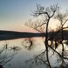
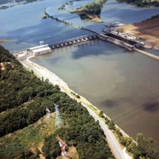
Eufaula Lake is a reservoir on the Canadian River near Eufaula in eastern Oklahoma, covering roughly 102,000 acres of water surface with around 600 miles of shoreline. The lake sits surrounded by rolling hills and wide stretches of woodland that line the banks and form dozens of coves.

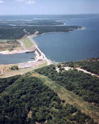
Construction of Eufaula Dam began in 1956 and ended in 1964 when the basin started filling gradually. President Lyndon Johnson dedicated the dam structure, which holds back water from several river channels and controls flood events downstream.

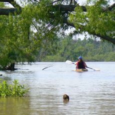
The reservoir takes its name from the nearby town and the Eufaula Creek people who once lived in this region. Anglers gather at boat ramps in the early morning, each knowing their preferred spot for catfish or bass.

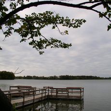
Boat ramps and marinas are spread around the water and offer access to different parts of the lake. Those arriving early in the day find less traffic and calmer conditions for fishing or boating.

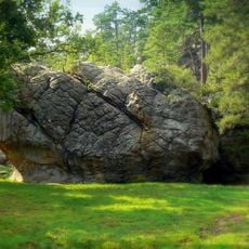
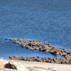
The water has submerged an old landmark called Standing Rock, which now sits about 25 feet below the surface. Divers can see the upper parts of this submerged rock formation when water levels are lower.

The community of curious travelers

AroundUs brings together thousands of curated places, local tips, and hidden gems, enriched daily by 60,000 contributors worldwide.

Start exploring
Location
Elevation above the sea
178 m
GPS coordinates
35.28083,-95.52972
Latest update
December 14, 2025 18:52
Around this place
Robbers Cave State Park
United States of America

Robbers Cave State Park

35.4 km
Greenleaf State Park
United States of America

Greenleaf State Park

50.2 km
Arrowhead State Park
United States of America

Arrowhead State Park

15.7 km
Lake Eufaula State Park
United States of America

Lake Eufaula State Park

15.5 km
Deep Fork National Wildlife Refuge
United States of America

Deep Fork National Wildlife Refuge

52 km
International Temple, Supreme Assembly, Order of the Rainbow for Girls
United States of America

International Temple, Supreme Assembly, Order of the Rainbow for Girls

44.3 km
Webbers Falls Lake
United States of America

Webbers Falls Lake

43.7 km
Manhattan Building
United States of America

Manhattan Building

54.1 km
Aldridge Hotel
United States of America

Aldridge Hotel

44.4 km
St. Joseph's Catholic Church
United States of America

St. Joseph's Catholic Church

42.4 km
Oklahoma Odd Fellows Home at Checotah
United States of America

Oklahoma Odd Fellows Home at Checotah

22.1 km
Severs Hotel
United States of America

Severs Hotel

54 km
McAlester House
United States of America

McAlester House

41.9 km
McAlester Scottish Rite Temple
United States of America

McAlester Scottish Rite Temple

44.1 km
Sacred Heart Catholic Church and Rectory
United States of America

Sacred Heart Catholic Church and Rectory

45.1 km
Cole Chapel School
United States of America

Cole Chapel School

41.8 km
Surety Building
United States of America

Surety Building

54.1 km
St. Thomas Primitive Baptist Church
United States of America

St. Thomas Primitive Baptist Church

44.3 km
River Country Water Park
United States of America

River Country Water Park

53.2 km
Ed Edmondson United States Courthouse
United States of America

Ed Edmondson United States Courthouse

54 km
Kinta High School
United States of America

Kinta High School

32.8 km
First Presbyterian Church
United States of America

First Presbyterian Church

44.7 km
Haskell County Courthouse
United States of America

Haskell County Courthouse

41 km
First United Methodist Church
United States of America

First United Methodist Church

21.1 km
Oklahoma Music Hall of Fame
United States of America

Oklahoma Music Hall of Fame

53.7 km
Lake Eufala Dam ORV Area
United States of America

Lake Eufala Dam ORV Area

16.1 km
Okla Theatre
United States of America

Okla Theatre

44.5 km
Honey Springs Battlefield
United States of America

Honey Springs Battlefield

28.2 km
Show the full map
« Eufaula Lake - Reservoir at Canadian River near Eufaula, Oklahoma, United States » is provided by Around Us (aroundus.com). Images and texts are derived from Wikimedia project under a Creative Commons license. You are allowed to copy, distribute, and modify copies of this page, under the conditions set by the license, as long as this note is clearly visible.

Discover hidden gems everywhere you go!

From secret cafés to breathtaking viewpoints, skip the crowded tourist spots and find places that match your style. Our app makes it easy with voice search, smart filtering, route optimization, and insider tips from travelers worldwide. Download now for the complete mobile experience.

Around Us App Screenshot

A unique approach to discovering new places

Le Figaro

All the places worth exploring

France Info

A tailor-made excursion in just a few clicks

20 Minutes

Around Us
Travel Guide & Maps
Download

Send to your phone

QR Code
1

Open the camera app on your mobile.

2

Point at the QR code with your camera. A notification will appear.

3

Tap the notification to open the link.