Deep Fork National Wildlife Refuge

Log in to your account

AroundUs is a community-driven map of interesting places, built by curious explorers like you. It grows with every review, story, and photo you share.
Connect to save your favorite spots, contribute locations, and create personalized routes.
Continue with Google
Continue with Apple
Continue with X
Continue with Facebook
Continue with email
By continuing, you accept our Terms and Conditions and our Privacy Policy
Create an account

Deep Fork National Wildlife Refuge

Add to collection
Map
Suggest a change
Share

Deep Fork National Wildlife Refuge, National wildlife refuge in eastern Oklahoma, United States.

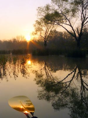
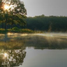
Deep Fork National Wildlife Refuge is a protected area along a river in eastern Oklahoma containing mixed bottomland forests with hardwood trees. The refuge features multiple designated zones that visitors can explore on foot, each with different natural landscapes and vegetation.

The refuge was established in the 1990s to protect the last remaining bottomland forests in Oklahoma. The area still shows traces of older human activities such as former pecan orchards and railway routes.

The refuge offers educational programs to 2,000 students annually, including the Okmulgee County Archery Day and environmental conservation activities.

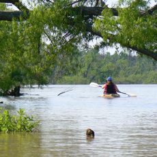
The refuge has walking trails of varying lengths with parking areas at multiple access points. Visitors should wear comfortable shoes and be prepared for different trail types, from open paths to wooden boardwalks.

The refuge serves as a critical stopover for migratory birds that pass through the region twice yearly. Bird enthusiasts can observe a wide range of avian species here.

Location: Oklahoma

Inception: 1993

Website: https://fws.gov/refuge/deep_fork

GPS coordinates: 35.58330,-95.96670

Latest update: December 12, 2025 14:27

Photos
Around this place
Eufaula Lake
United States of America

Eufaula Lake

52 km
Southern Hills Country Club
United States of America

Southern Hills Country Club

54.5 km
Prayer Tower
United States of America

Prayer Tower

52 km
Oklahoma Aquarium
United States of America

Oklahoma Aquarium

48.6 km
United States of America

Glenn Pool Oil Reserve

42.4 km
Creek National Capitol
United States of America

Creek National Capitol

4.4 km
Five Civilized Tribes Museum
United States of America

Five Civilized Tribes Museum

53.8 km
Lake Eufaula State Park
United States of America

Lake Eufaula State Park

38.2 km
John Frank House
United States of America

John Frank House

46.2 km
Sherwin Miller Museum of Jewish Art
United States of America

Sherwin Miller Museum of Jewish Art

53.3 km
Eastside Baptist Church
United States of America

Eastside Baptist Church

4.8 km
United States of America

Washington Irving Memorial Park and Arboretum

42.8 km
Okmulgee Park
United States of America

Okmulgee Park

8.6 km
Boley Historic District
United States of America

Boley Historic District

47.8 km
Oklahoma Odd Fellows Home at Checotah
United States of America

Oklahoma Odd Fellows Home at Checotah

42 km
First Baptist Central Church
United States of America

First Baptist Central Church

4.9 km
St. Anthony's Catholic Church
United States of America

St. Anthony's Catholic Church

3.9 km
St. Thomas Primitive Baptist Church
United States of America

St. Thomas Primitive Baptist Church

50 km
Bristow Presbyterian Church
United States of America

Bristow Presbyterian Church

47.5 km
First Presbyterian Church
United States of America

First Presbyterian Church

50.5 km
Broken Arrow Lanes
United States of America

Broken Arrow Lanes

49.3 km
Jackson Park Splash Pad
United States of America

Jackson Park Splash Pad

51.2 km
River Country Water Park
United States of America

River Country Water Park

53.9 km
Okmulgee Downtown Historic District
United States of America

Okmulgee Downtown Historic District

4.4 km
First United Methodist Church
United States of America

First United Methodist Church

42 km
Sonic
United States of America

Sonic

47.8 km
Broken Arrow Warren
United States of America

Broken Arrow Warren

47.8 km
Honey Springs Battlefield
United States of America

Honey Springs Battlefield

43.9 km
Show the full map
Reviews

Visited this place? Tap the stars to rate it and share your experience / photos with the community! Try now! You can cancel it anytime.

« Deep Fork National Wildlife Refuge - National wildlife refuge in eastern Oklahoma, United States » is provided by Around Us (aroundus.com). Images and texts are derived from Wikimedia project under a Creative Commons license. You are allowed to copy, distribute, and modify copies of this page, under the conditions set by the license, as long as this note is clearly visible.

Discover hidden gems everywhere you go!

From secret cafés to breathtaking viewpoints, skip the crowded tourist spots and find places that match your style. Our app makes it easy with voice search, smart filtering, route optimization, and insider tips from travelers worldwide. Download now for the complete mobile experience.

Around Us App Screenshot

A unique approach to discovering new places

Le Figaro

All the places worth exploring

France Info

A tailor-made excursion in just a few clicks

20 Minutes