Enable Location

We need your location to show you interesting places around you

Discover nearby places

Find interesting locations and hidden gems around you

Precise directions

Get accurate directions and distances to places

Your location is never shared with other users. It's only used when you tap the location button.

Creek National Capitol

Log in to your account

Start exploring — it's free

Trusted by 61,972 travelers worldwide

Continue with Google
Continue with Apple
or

We will send you a code to connect

By continuing, you accept our Terms and Conditions and our Privacy Policy

Check your inbox

We've sent a pincode in your inbox. Please enter the code below.

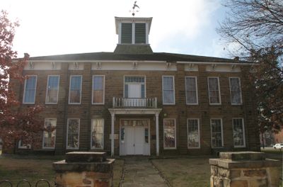
Creek National Capitol, Capitol building in Okmulgee, United States.

Creek National Capitol is a stone building in Okmulgee with separate chambers for the executive, judicial, and legislative branches of tribal government. The structure reflects how the three branches of power were organized in distinct rooms.

The building was completed in 1878 and served as the Creek Nation's governmental seat until Oklahoma statehood in 1907, when tribal self-governance ended. After this point, the building lost its original function for nearly a century.

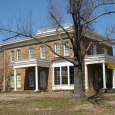
The building displays exhibits about Creek traditions and daily life that visitors can experience firsthand. The rooms tell the story of governance and everyday life across many generations of this nation.

The building sits at the intersection of 6th Street and Grand Avenue, making it easy to locate. Educational programs about Creek Nation history are available to help visitors understand the tribal heritage better.

The building changed hands for many years and faded from public attention until the Muscogee Creek Nation repurchased it. This reacquisition marked an important step in reclaiming the nation's heritage.

The community of curious travelers

AroundUs brings together thousands of curated places, local tips, and hidden gems, enriched daily by 60,000 contributors worldwide.

Start exploring
Location
Inception
1878
GPS coordinates
35.62271,-95.97251
Latest update
December 11, 2025 18:05
Around this place
Southern Hills Country Club
United States of America

Southern Hills Country Club

50.1 km
Westhope
United States of America

Westhope

54.2 km
Prayer Tower
United States of America

Prayer Tower

47.7 km
Oklahoma Aquarium
United States of America

Oklahoma Aquarium

44.2 km
United States of America

Glenn Pool Oil Reserve

37.9 km
Five Civilized Tribes Museum
United States of America

Five Civilized Tribes Museum

52.8 km
Lake Eufaula State Park
United States of America

Lake Eufaula State Park

41.1 km
Deep Fork National Wildlife Refuge
United States of America

Deep Fork National Wildlife Refuge

4.4 km
John Frank House
United States of America

John Frank House

41.9 km
Sherwin Miller Museum of Jewish Art
United States of America

Sherwin Miller Museum of Jewish Art

48.9 km
Eastside Baptist Church
United States of America

Eastside Baptist Church

1.3 km
United States of America

Washington Irving Memorial Park and Arboretum

38.6 km
Okmulgee Park
United States of America

Okmulgee Park

8.3 km
Boley Historic District
United States of America

Boley Historic District

48.3 km
Oklahoma Odd Fellows Home at Checotah
United States of America

Oklahoma Odd Fellows Home at Checotah

43.9 km
First Baptist Central Church
United States of America

First Baptist Central Church

590 m
St. Anthony's Catholic Church
United States of America

St. Anthony's Catholic Church

488 m
St. Thomas Primitive Baptist Church
United States of America

St. Thomas Primitive Baptist Church

49.9 km
Bristow Presbyterian Church
United States of America

Bristow Presbyterian Church

44.6 km
First Presbyterian Church
United States of America

First Presbyterian Church

47.2 km
Okmulgee Downtown Historic District
United States of America

Okmulgee Downtown Historic District

228 m
Bristow Firestone Service Station
United States of America

Bristow Firestone Service Station

44.6 km
First United Methodist Church
United States of America

First United Methodist Church

44 km
Texaco Service Station
United States of America

Texaco Service Station

44.5 km
Teepee Drive-In
United States of America

Teepee Drive-In

44.1 km
Broken Arrow Warren
United States of America

Broken Arrow Warren

43.8 km
Honey Springs Battlefield
United States of America

Honey Springs Battlefield

45.2 km
Nichols Park South Picnic Shelter
United States of America

Nichols Park South Picnic Shelter

24.2 km
Show the full map
« Creek National Capitol - Capitol building in Okmulgee, United States » is provided by Around Us (aroundus.com). Images and texts are derived from Wikimedia project under a Creative Commons license. You are allowed to copy, distribute, and modify copies of this page, under the conditions set by the license, as long as this note is clearly visible.

Discover hidden gems everywhere you go!

From secret cafés to breathtaking viewpoints, skip the crowded tourist spots and find places that match your style. Our app makes it easy with voice search, smart filtering, route optimization, and insider tips from travelers worldwide. Download now for the complete mobile experience.

Around Us App Screenshot

A unique approach to discovering new places

Le Figaro

All the places worth exploring

France Info

A tailor-made excursion in just a few clicks

20 Minutes

Around Us
Travel Guide & Maps
Download

Send to your phone

QR Code
1

Open the camera app on your mobile.

2

Point at the QR code with your camera. A notification will appear.

3

Tap the notification to open the link.