Enable Location

We need your location to show you interesting places around you

Discover nearby places

Find interesting locations and hidden gems around you

Precise directions

Get accurate directions and distances to places

Your location is never shared with other users. It's only used when you tap the location button.

Honey Springs Battlefield

Log in to your account

Start exploring — it's free

Trusted by 62,556 travelers worldwide

Continue with Google
Continue with Apple
or

We will send you a code to connect

By continuing, you accept our Terms and Conditions and our Privacy Policy

Check your inbox

We've sent a pincode in your inbox. Please enter the code below.

Honey Springs Battlefield, Civil War battlefield in McIntosh County and Muskogee County, United States.

Honey Springs Battlefield spans 1,100 acres across two counties with walking paths that connect key locations where troops engaged during the Civil War. The terrain reveals how soldiers positioned themselves across ridges and open ground during the fighting.

Union forces under Major General James G. Blunt defeated Confederate troops led by Brigadier General Douglas Cooper in July 1863. The victory gave the Union control of a strategic area in Indian Territory.

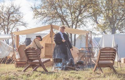
The battlefield was where soldiers from different backgrounds fought side by side in integrated Union Army units. Visitors can walk the grounds and grasp how this mixing of troops shaped the battle's outcome.

A visitor center with displays and six hiking trails of varying length guide you through the grounds. Wear comfortable shoes and bring water, as some paths cross open areas with little shade.

This was the largest Civil War engagement in Indian Territory, drawing over 9,000 soldiers to the field. The four-hour battle demonstrated the capability of integrated military units working together.

The community of curious travelers

AroundUs brings together thousands of curated places, local tips, and hidden gems, enriched daily by 60,000 contributors worldwide.

Start exploring
Location
Location
GPS coordinates
35.53139,-95.48583
Latest update
December 15, 2025 13:25
Around this place
Eufaula Lake
United States of America

Eufaula Lake

28.2 km
USS Batfish
United States of America

USS Batfish

33.3 km
Fort Gibson
United States of America

Fort Gibson

36.7 km
Greenleaf State Park
United States of America

Greenleaf State Park

30.4 km
Fort Gibson National Cemetery
United States of America

Fort Gibson National Cemetery

38.2 km
Five Civilized Tribes Museum
United States of America

Five Civilized Tribes Museum

26.7 km
Lake Eufaula State Park
United States of America

Lake Eufaula State Park

17.9 km
Webbers Falls Lake
United States of America

Webbers Falls Lake

22.7 km
Manhattan Building
United States of America

Manhattan Building

26.4 km
Oklahoma Odd Fellows Home at Checotah
United States of America

Oklahoma Odd Fellows Home at Checotah

6.6 km
Chouteau Lock & Dam
United States of America

Chouteau Lock & Dam

37.8 km
A.W. Patterson House
United States of America

A.W. Patterson House

26.4 km
Grant Foreman House
United States of America

Grant Foreman House

26.3 km
First Baptist Church
United States of America

First Baptist Church

26.6 km
Commandant's Quarters
United States of America

Commandant's Quarters

37.4 km
Ward Chapel AME Church
United States of America

Ward Chapel AME Church

26.7 km
Surety Building
United States of America

Surety Building

26.4 km
Railway Exchange Building
United States of America

Railway Exchange Building

26.5 km
St. Thomas Primitive Baptist Church
United States of America

St. Thomas Primitive Baptist Church

16.3 km
A. C. Trumbo House
United States of America

A. C. Trumbo House

26.4 km
V. R. Coss House
United States of America

V. R. Coss House

26.3 km
Ed Edmondson United States Courthouse
United States of America

Ed Edmondson United States Courthouse

26.3 km
Central Baptist Church
United States of America

Central Baptist Church

26.8 km
United States of America

Hotel Muskogee

26.4 km
First United Methodist Church
United States of America

First United Methodist Church

7.6 km
Fort Gibson State Historic Site
United States of America

Fort Gibson State Historic Site

36.7 km
Oklahoma Music Hall of Fame
United States of America

Oklahoma Music Hall of Fame

25.9 km
Tenkiller Ferry Dam
United States of America

Tenkiller Ferry Dam

41.1 km
Show the full map
« Honey Springs Battlefield - Civil War battlefield in McIntosh County and Muskogee County, United States » is provided by Around Us (aroundus.com). Images and texts are derived from Wikimedia project under a Creative Commons license. You are allowed to copy, distribute, and modify copies of this page, under the conditions set by the license, as long as this note is clearly visible.

Discover hidden gems everywhere you go!

From secret cafés to breathtaking viewpoints, skip the crowded tourist spots and find places that match your style. Our app makes it easy with voice search, smart filtering, route optimization, and insider tips from travelers worldwide. Download now for the complete mobile experience.

Around Us App Screenshot

A unique approach to discovering new places

Le Figaro

All the places worth exploring

France Info

A tailor-made excursion in just a few clicks

20 Minutes

Around Us
Travel Guide & Maps
Download

Send to your phone

QR Code
1

Open the camera app on your mobile.

2

Point at the QR code with your camera. A notification will appear.

3

Tap the notification to open the link.