Chest opened
+${chestReward.xp} XP
Explorer
NOUVEAU ×${chestReward.collectible.quantity}
tapez pour fermer
Chest locked

Open chests in the app

Around Us is built for your phone — chests unlock when you walk, explore and capture nearby places.

Enable Location

We need your location to show you interesting places around you

Discover nearby places

Find interesting locations and hidden gems around you

Precise directions

Get accurate directions and distances to places

Your location is never shared with other users. It's only used when you tap the location button.

Log in to your account

Start exploring — it's free

Trusted by 72,881 travelers worldwide

Continue with Google
Continue with Apple
or

We will send you a code to connect

By continuing, you accept our Terms and Conditions and our Privacy Policy

Check your inbox

We've sent a pincode in your inbox. Please enter the code below.

Lake W. R. Holway
Discussion Reviews Photo
2.4k Popularity

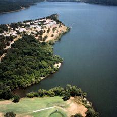
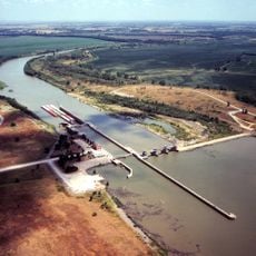
Lake W. R. Holway, Recreational reservoir in Mayes County, Oklahoma.

Lake W. R. Holway is a reservoir in Mayes County featuring an expansive water surface with a long shoreline and varying depths throughout. The lake has designated water access points and specific rules about which boats are allowed.

The reservoir was built in the late 1960s under its original name and was later renamed to honor someone connected to its development. The project was part of a larger water management initiative in the region managed by a regional authority.

This reservoir serves the local community as a fishing and recreation destination where people spend time on the water throughout the year. The lake draws visitors who enjoy quiet water activities and appreciate the natural setting for outdoor pursuits.

Access to the water is provided through two dedicated boat launch areas where visitors can enter the water with their vessels. Visitors should know that only certain types of boats are permitted on the lake.

The reservoir operates as part of a pumped storage system that generates electricity during peak demand times. This dual function means the water levels can fluctuate based on energy needs rather than just natural conditions.

The community of curious travelers

AroundUs brings together thousands of curated places, local tips, and hidden gems, enriched daily by 60,000 contributors worldwide.

Start exploring
Location
GPS coordinates
36.25280,-95.09860
Latest update
December 13, 2025 11:41
Around this place
Natural Falls State Park
United States of America

Natural Falls State Park

39.8 km
Pensacola Dam
United States of America

Pensacola Dam

25.1 km
Sequoyah State Park
United States of America

Sequoyah State Park

39.7 km
Monastery of Our Lady of the Annunciation of Clear Creek
United States of America

Monastery of Our Lady of the Annunciation of Clear Creek

25.9 km
Cherokee National Capitol
United States of America

Cherokee National Capitol

39.6 km
Cherokee Heritage Center
United States of America

Cherokee Heritage Center

44.8 km
Fort Gibson Dam
United States of America

Fort Gibson Dam

44.3 km
Cherokee National Holiday
United States of America

Cherokee National Holiday

39.3 km
Cherokee Female Seminary
United States of America

Cherokee Female Seminary

38.8 km
Ed Galloway's Totem Pole Park
United States of America

Ed Galloway's Totem Pole Park

37.5 km
Lake Eucha
United States of America

Lake Eucha

23.8 km
Doc Wadley Stadium
United States of America

Doc Wadley Stadium

38 km
Ozark Plateau National Wildlife Refuge
United States of America

Ozark Plateau National Wildlife Refuge

35.6 km
Attucks School
United States of America

Attucks School

42.3 km
First Methodist Episcopal Church, South
United States of America

First Methodist Episcopal Church, South

43.2 km
Cherokee National Jail
United States of America

Cherokee National Jail

39.7 km
Wagoner Armory
United States of America

Wagoner Armory

40.8 km
Newt Graham Lock & Dam
United States of America

Newt Graham Lock & Dam

45 km
Frederick Parkinson House
United States of America

Frederick Parkinson House

40.6 km
Hildebrand Mill
United States of America

Hildebrand Mill

38.9 km
John W. Gibson House
United States of America

John W. Gibson House

40.9 km
St. James Episcopal Church
United States of America

St. James Episcopal Church

41.1 km
American Legion Hut
United States of America

American Legion Hut

39.6 km
Ed Galloway's Totem Pole Park
United States of America

Ed Galloway's Totem Pole Park

37.5 km
Collin McKinney House
United States of America

Collin McKinney House

41.1 km
Lost City
United States of America

Lost City

26.7 km
Claremore Lake Splash Pad
United States of America

Claremore Lake Splash Pad

44.3 km
Eastern Trails Museum
United States of America

Eastern Trails Museum

43.3 km
Show the full map
Reviews
Share your experience

No review yet

Discussions
Start a discussion...

No discussion yet

« Lake W. R. Holway - Recreational reservoir in Mayes County, Oklahoma » is provided by Around Us (aroundus.com). Images and texts are derived from Wikimedia project under a Creative Commons license. You are allowed to copy, distribute, and modify copies of this page, under the conditions set by the license, as long as this note is clearly visible.

Discover hidden gems everywhere you go!

From secret cafés to breathtaking viewpoints, skip the crowded tourist spots and find places that match your style. Our app makes it easy with voice search, smart filtering, route optimization, and insider tips from travelers worldwide. Download now for the complete mobile experience.

Around Us App Screenshot

A unique approach to discovering new places

Le Figaro

All the places worth exploring

France Info

A tailor-made excursion in just a few clicks

20 Minutes

Around Us
Travel Guide & Maps
Download

Send to your phone

QR Code
1

Open the camera app on your mobile.

2

Point at the QR code with your camera. A notification will appear.

3

Tap the notification to open the link.