Enable Location

We need your location to show you interesting places around you

Discover nearby places

Find interesting locations and hidden gems around you

Precise directions

Get accurate directions and distances to places

Your location is never shared with other users. It's only used when you tap the location button.

Pensacola Dam

Log in to your account

Start exploring — it's free

Trusted by 64,813 travelers worldwide

Continue with Google
Continue with Apple
or

We will send you a code to connect

By continuing, you accept our Terms and Conditions and our Privacy Policy

Check your inbox

We've sent a pincode in your inbox. Please enter the code below.

Discussion Reviews 1 Photos
11.9k Popularity

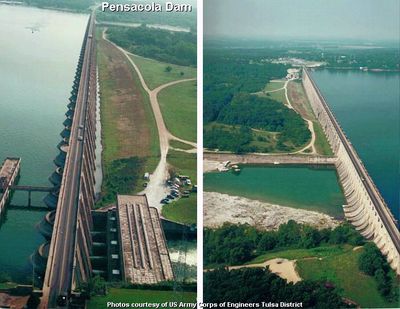
Pensacola Dam, dam in Mayes County, Oklahoma, United States of America

Pensacola Dam is a dam and hydroelectric power station on the Grand River in Mayes County, Oklahoma. It holds back the river to form Grand Lake o' the Cherokees, one of the largest reservoirs in the state.

The dam was completed in 1940, at a time when Oklahoma was actively developing its water and power infrastructure. Its construction reshaped the Grand River and permanently changed the landscape of northeastern Oklahoma.

The dam is visible from the road that crosses it, making it easy to stop and get a look at the structure and the lake behind it. Since it is an operating facility, access is limited in some areas, so it is best to stay on public roads and designated viewpoints.

Pensacola Dam is one of the longest multiple-arch dams in the world, stretching nearly 1.2 miles (about 1.9 km) from one bank to the other. This type of design, where a series of arches carries the water load, was relatively uncommon and required specialized engineering for its time.

The community of curious travelers

AroundUs brings together thousands of curated places, local tips, and hidden gems, enriched daily by 60,000 contributors worldwide.

Start exploring
Location
Architects
John Duncan Forsyth
GPS coordinates
36.47194,-95.03250
Latest update
March 3, 2026 08:21
Around this place
Grand Lake o' the Cherokees
United States of America

Grand Lake o' the Cherokees

23.1 km
Natural Falls State Park
United States of America

Natural Falls State Park

46.7 km
Monastery of Our Lady of the Annunciation of Clear Creek
United States of America

Monastery of Our Lady of the Annunciation of Clear Creek

50.9 km
Ed Galloway's Totem Pole Park
United States of America

Ed Galloway's Totem Pole Park

37.4 km
Old Spanish Treasure Cave
United States of America

Old Spanish Treasure Cave

51.2 km
Lake Eucha
United States of America

Lake Eucha

21.3 km
Ozark Plateau National Wildlife Refuge
United States of America

Ozark Plateau National Wildlife Refuge

33.6 km
Coleman Theatre
United States of America

Coleman Theatre

47.1 km
Splitlog Church
United States of America

Splitlog Church

36.3 km
Attucks School
United States of America

Attucks School

20.6 km
First Methodist Episcopal Church, South
United States of America

First Methodist Episcopal Church, South

21.6 km
George L. Coleman Sr. House
United States of America

George L. Coleman Sr. House

48.3 km
Bluff Dwellers Cave
United States of America

Bluff Dwellers Cave

49.1 km
OKARMO Corner
United States of America

OKARMO Corner

37.2 km
Coon Creek Bridge
United States of America

Coon Creek Bridge

46 km
Wee Pine Knot
United States of America

Wee Pine Knot

51.1 km
Hildebrand Mill
United States of America

Hildebrand Mill

44.5 km
Shiloh House
United States of America

Shiloh House

51.7 km
Ed Galloway's Totem Pole Park
United States of America

Ed Galloway's Totem Pole Park

37.4 km
Sulphur Springs Park Reserve
United States of America

Sulphur Springs Park Reserve

51.6 km
Coats School
United States of America

Coats School

43.7 km
Adar House
United States of America

Adar House

49.9 km
Sulphur Springs Old School Complex Historic District
United States of America

Sulphur Springs Old School Complex Historic District

51.1 km
Corey House/Hotel
United States of America

Corey House/Hotel

27.2 km
Lost City
United States of America

Lost City

51.8 km
Jones House
United States of America

Jones House

51.3 km
Splash Park
United States of America

Splash Park

27.7 km
Eastern Trails Museum
United States of America

Eastern Trails Museum

21.7 km
Show the full map
Reviews
Share your experience

No review yet

Discussions
Start a discussion...

No discussion yet

« Pensacola Dam - dam in Mayes County, Oklahoma, United States of America » is provided by Around Us (aroundus.com). Images and texts are derived from Wikimedia project under a Creative Commons license. You are allowed to copy, distribute, and modify copies of this page, under the conditions set by the license, as long as this note is clearly visible.

Discover hidden gems everywhere you go!

From secret cafés to breathtaking viewpoints, skip the crowded tourist spots and find places that match your style. Our app makes it easy with voice search, smart filtering, route optimization, and insider tips from travelers worldwide. Download now for the complete mobile experience.

Around Us App Screenshot

A unique approach to discovering new places

Le Figaro

All the places worth exploring

France Info

A tailor-made excursion in just a few clicks

20 Minutes

Around Us
Travel Guide & Maps
Download

Send to your phone

QR Code
1

Open the camera app on your mobile.

2

Point at the QR code with your camera. A notification will appear.

3

Tap the notification to open the link.