Chest opened
+${chestReward.xp} XP
Explorer
NOUVEAU ×${chestReward.collectible.quantity}
tapez pour fermer
Chest locked

Open chests in the app

Around Us is built for your phone — chests unlock when you walk, explore and capture nearby places.

Enable Location

We need your location to show you interesting places around you

Discover nearby places

Find interesting locations and hidden gems around you

Precise directions

Get accurate directions and distances to places

Your location is never shared with other users. It's only used when you tap the location button.

Bjelašnica

Log in to your account

Start exploring — it's free

Trusted by 72,888 travelers worldwide

Continue with Google
Continue with Apple
or

We will send you a code to connect

By continuing, you accept our Terms and Conditions and our Privacy Policy

Check your inbox

We've sent a pincode in your inbox. Please enter the code below.

Bjelašnica
Discussion Reviews 1 Photos
13.3k Popularity

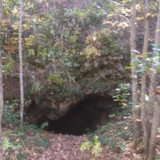
Bjelašnica, Mountain range in Trnovo Municipality, Bosnia and Herzegovina

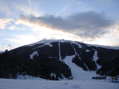
Bjelašnica is a mountain range with limestone peaks reaching 2,067 meters, with snow covering the slopes from November through May. The range features ski slopes and chairlifts for winter sports as well as hiking trails during warmer months.

The Austro-Hungarian Empire established the first weather station in 1878 and began systematic observations in the Balkan region. This scientific work continued through generations and shapes the mountain range to this day.

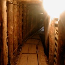
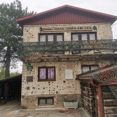
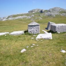
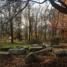
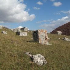
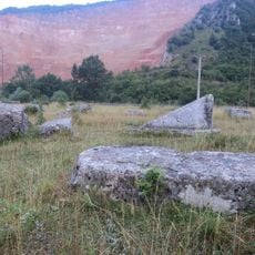
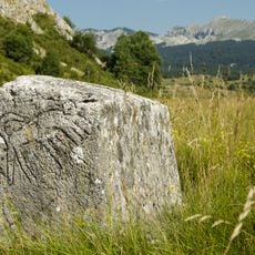
The village of Lukomir on the slopes keeps traditional houses and two medieval burial grounds with stone monuments called stećci. These places show how people lived here across centuries and honored their dead.

In winter, visitors can use the ski slopes and chairlifts, while access in other seasons is through hiking trails. Bring weather-appropriate clothing, as conditions at higher elevations can change quickly.

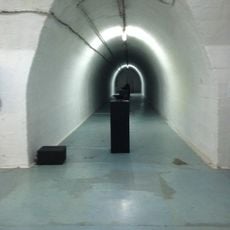
The research station at the summit is the highest permanently inhabited place in Bosnia and Herzegovina. Weather data has been collected there continuously for over a hundred years, providing key insights into the mountain climate of the region.

The community of curious travelers

AroundUs brings together thousands of curated places, local tips, and hidden gems, enriched daily by 60,000 contributors worldwide.

Start exploring
Elevation above the sea
2,067 m
GPS coordinates
43.70400,18.25700
Latest update
December 7, 2025 20:40
Around this place
Sarajevo Tunnel
Bosnia and Herzegovina

Sarajevo Tunnel

14.4 km
Vrelo Bosne
Bosnia and Herzegovina

Vrelo Bosne

12.8 km
Armijska Ratna Komanda
Bosnia and Herzegovina

Armijska Ratna Komanda

22.5 km
Tunnel of Salvation
Bosnia and Herzegovina

Tunnel of Salvation

14.4 km
Terme Ilidža
Bosnia and Herzegovina

Terme Ilidža

14.5 km
King Fahd Mosque
Bosnia and Herzegovina

King Fahd Mosque

16.6 km
Stara Ćuprija
Bosnia and Herzegovina

Stara Ćuprija

24.4 km
Roman bridge in Ilidža
Bosnia and Herzegovina

Roman bridge in Ilidža

14.4 km
Velika aleja
Bosnia and Herzegovina

Velika aleja

13.5 km
Bosnia and Herzegovina

Azići

16.4 km
Saint Basil of Ostrog church (Istočno Sarajevo)
Bosnia and Herzegovina

Saint Basil of Ostrog church (Istočno Sarajevo)

15.8 km
Tekija-Moschee in Konjic
Bosnia and Herzegovina

Tekija-Moschee in Konjic

24.6 km
Gavrilo Princip park
Bosnia and Herzegovina

Gavrilo Princip park

15.5 km
Poljice necropolis
Bosnia and Herzegovina

Poljice necropolis

14.1 km
Црква Вазнесења Господњег у Војковићима
Serbia

Црква Вазнесења Господњег у Војковићима

12.8 km
Црква Светог великомученика Георгија у Трнову
Serbia

Црква Светог великомученика Георгија у Трнову

15.9 km
Umoljani mosque
Bosnia and Herzegovina

Umoljani mosque

4.8 km
Crkvina stećaks necropolis and remains of a pre-Romanesque church
Bosnia and Herzegovina

Crkvina stećaks necropolis and remains of a pre-Romanesque church

12.9 km
Church of the Assumption in Stup
Bosnia and Herzegovina

Church of the Assumption in Stup

16.4 km
Umoljani necropolis
Bosnia and Herzegovina

Umoljani necropolis

5.7 km
Carmelite Monastery in Stup
Bosnia and Herzegovina

Carmelite Monastery in Stup

16.2 km
Klokočevica
Bosnia and Herzegovina

Klokočevica

3.3 km
East Sarajevo Children's Library
Bosnia and Herzegovina

East Sarajevo Children's Library

15.8 km
Krupac necropolis
Bosnia and Herzegovina

Krupac necropolis

11.8 km
Gvozno graveyard
Bosnia and Herzegovina

Gvozno graveyard

21.9 km
Hotel Igman
Bosnia and Herzegovina

Hotel Igman

4.7 km
Oslobođenje
Bosnia and Herzegovina

Oslobođenje

16.8 km
Varda Meskita
Bosnia and Herzegovina

Varda Meskita

24.6 km
Show the full map
Reviews
Share your experience

No review yet

Discussions
Start a discussion...

No discussion yet

« Bjelašnica - Mountain range in Trnovo Municipality, Bosnia and Herzegovina » is provided by Around Us (aroundus.com). Images and texts are derived from Wikimedia project under a Creative Commons license. You are allowed to copy, distribute, and modify copies of this page, under the conditions set by the license, as long as this note is clearly visible.

Discover hidden gems everywhere you go!

From secret cafés to breathtaking viewpoints, skip the crowded tourist spots and find places that match your style. Our app makes it easy with voice search, smart filtering, route optimization, and insider tips from travelers worldwide. Download now for the complete mobile experience.

Around Us App Screenshot

A unique approach to discovering new places

Le Figaro

All the places worth exploring

France Info

A tailor-made excursion in just a few clicks

20 Minutes

Around Us
Travel Guide & Maps
Download

Send to your phone

QR Code
1

Open the camera app on your mobile.

2

Point at the QR code with your camera. A notification will appear.

3

Tap the notification to open the link.