Chest opened
+${chestReward.xp} XP
Explorer
NOUVEAU ×${chestReward.collectible.quantity}
tapez pour fermer
Chest locked

Open chests in the app

Around Us is built for your phone — chests unlock when you walk, explore and capture nearby places.

Enable Location

We need your location to show you interesting places around you

Discover nearby places

Find interesting locations and hidden gems around you

Precise directions

Get accurate directions and distances to places

Your location is never shared with other users. It's only used when you tap the location button.

Saint John River

Log in to your account

Start exploring — it's free

Trusted by 72,879 travelers worldwide

Continue with Google
Continue with Apple
or

We will send you a code to connect

By continuing, you accept our Terms and Conditions and our Privacy Policy

Check your inbox

We've sent a pincode in your inbox. Please enter the code below.

Saint John River
Discussion Reviews 3 Photos
31.2k Popularity

Saint John River, River system in New Brunswick and Maine, Canada and United States.

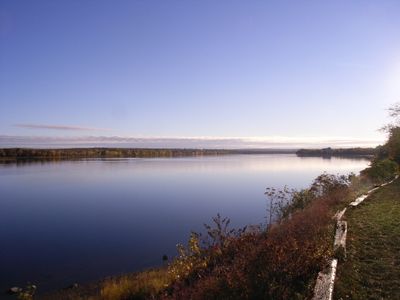
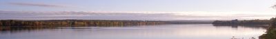
The Saint John River is a waterway that stretches about 673 kilometers from the Notre Dame Mountains through western New Brunswick to the Bay of Fundy. The river flows through mountainous terrain and forested regions before reaching the Atlantic.

French explorer Samuel de Champlain named the river in 1604 after encountering it on the feast day of Saint John the Baptist. The name remained in use through centuries of European settlement and development in the region.

The Wolastoqiyik people call this river Wolastoq, a name that speaks to the river's abundance and its importance as a source of life for their communities.

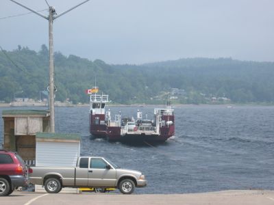
The river provides visitors with walking trails and access points along its banks, especially in areas with less developed surroundings. The best time to explore is during summer and early fall when weather is mild and roads are accessible.

At the mouth near Saint John, powerful tides from the Bay of Fundy create reversing rapids that reverse the river's flow twice daily. This rare phenomenon happens when Atlantic tidal forces overcome and reverse the normal downstream current.

The community of curious travelers

AroundUs brings together thousands of curated places, local tips, and hidden gems, enriched daily by 60,000 contributors worldwide.

Start exploring
Location
Location
GPS coordinates
45.26667,-66.06667
Latest update
December 20, 2025 01:35
Around this place
Houlton–Woodstock border crossing
Canada

Houlton–Woodstock border crossing

164.7 km
Double Eagle II
United States of America

Double Eagle II

214 km
Aroostook Valley Country Club
Canada

Aroostook Valley Country Club

216.5 km
Hartland Bridge
Canada

Hartland Bridge

161.4 km
Mars Hill
United States of America

Mars Hill

194.5 km
United States of America

Loring Commerce Centre

233.9 km
Aroostook National Wildlife Refuge
United States of America

Aroostook National Wildlife Refuge

233.4 km
Loring Air Force Base Double Cantilever Hangar
United States of America

Loring Air Force Base Double Cantilever Hangar

233 km
Loring Air Force Base Arch Hangar
United States of America

Loring Air Force Base Arch Hangar

233.5 km
National Weather Service Caribou, Maine
United States of America

National Weather Service Caribou, Maine

233.2 km
Fort Fairfield - Andover Border Crossing
Canada

Fort Fairfield - Andover Border Crossing

213.5 km
Mark and Emily Turner Memorial Library
United States of America

Mark and Emily Turner Memorial Library

217.8 km
United States of America

Watson Settlement Bridge

170.8 km
Florenceville Bridge
Canada

Florenceville Bridge

177.9 km
Cary Library
United States of America

Cary Library

167.6 km
Blackhawk Putnam Tavern
United States of America

Blackhawk Putnam Tavern

168.2 km
Aroostook County Courthouse and Jail
United States of America

Aroostook County Courthouse and Jail

167.7 km
Gray Memorial United Methodist Church and Parsonage
United States of America

Gray Memorial United Methodist Church and Parsonage

232.7 km
Charles Connell House
Canada

Charles Connell House

153.1 km
L. P. Fisher Public Library
Canada

L. P. Fisher Public Library

153 km
Hugh John Flemming Bridge
Canada

Hugh John Flemming Bridge

162.5 km
Unitarian Church of Houlton
United States of America

Unitarian Church of Houlton

167.5 km
Aroostook County Historical and Art Museum
United States of America

Aroostook County Historical and Art Museum

167.7 km
Market Square Historic District
United States of America

Market Square Historic District

167.8 km
Old Carleton County Court House
Canada

Old Carleton County Court House

154.9 km
Fort Fairfield Public Library
United States of America

Fort Fairfield Public Library

216.2 km
Philo Reed House
United States of America

Philo Reed House

215.1 km
Walter P. Mansur House
United States of America

Walter P. Mansur House

167.9 km
Show the full map
Reviews
Share your experience

No review yet

Discussions
Start a discussion...

No discussion yet

« Saint John River - River system in New Brunswick and Maine, Canada and United States » is provided by Around Us (aroundus.com). Images and texts are derived from Wikimedia project under a Creative Commons license. You are allowed to copy, distribute, and modify copies of this page, under the conditions set by the license, as long as this note is clearly visible.

Discover hidden gems everywhere you go!

From secret cafés to breathtaking viewpoints, skip the crowded tourist spots and find places that match your style. Our app makes it easy with voice search, smart filtering, route optimization, and insider tips from travelers worldwide. Download now for the complete mobile experience.

Around Us App Screenshot

A unique approach to discovering new places

Le Figaro

All the places worth exploring

France Info

A tailor-made excursion in just a few clicks

20 Minutes

Around Us
Travel Guide & Maps
Download

Send to your phone

QR Code
1

Open the camera app on your mobile.

2

Point at the QR code with your camera. A notification will appear.

3

Tap the notification to open the link.