Enable Location

We need your location to show you interesting places around you

Discover nearby places

Find interesting locations and hidden gems around you

Precise directions

Get accurate directions and distances to places

Your location is never shared with other users. It's only used when you tap the location button.

Lake Superior National Marine Conservation Area

Log in to your account

Start exploring — it's free

Trusted by 66,070 travelers worldwide

Continue with Google
Continue with Apple
or

We will send you a code to connect

By continuing, you accept our Terms and Conditions and our Privacy Policy

Check your inbox

We've sent a pincode in your inbox. Please enter the code below.

Lake Superior National Marine Conservation Area
Discussion Reviews 1 Photos
5.1k Popularity

Lake Superior National Marine Conservation Area, National marine conservation area in Thunder Bay District, Canada

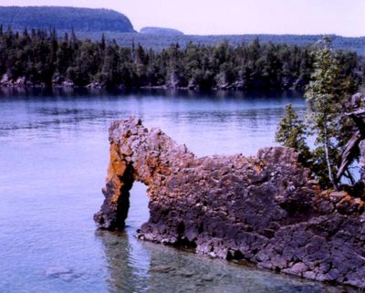
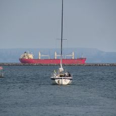
Lake Superior National Marine Conservation Area is a federally protected freshwater area along the northern shore of Lake Superior in Ontario, Canada, covering rocky coves, islands, and deep lake zones. The area also takes in a stretch of boreal forest along the coast, making it one of the few places where land and lake habitats are managed together.

The area was officially designated in 2015 after years of consultations with local First Nations communities who have lived along these shores for generations. This was part of a broader federal effort to extend marine conservation to freshwater environments, a relatively new approach in Canada at the time.

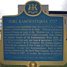
The waters have served as a major trade route for First Nations peoples and later fur trading companies over many centuries. Today, pictograph sites and remnants of trading networks remain visible evidence of this extended period of human activity.

The area is most accessible from late spring through early fall, when boating, kayaking, and hiking along the shore are all possible. Lake conditions can shift quickly, so checking forecasts before heading out is always a good idea, whatever the season.

More than 50 shipwrecks from different eras rest on the lake floor within this area, ranging from wooden sailing vessels to steel steamships. Because Lake Superior's water is extremely cold and low in nutrients, many of these wrecks have been preserved in a way that is rare for other lake systems, making them a draw for divers.

The community of curious travelers

AroundUs brings together thousands of curated places, local tips, and hidden gems, enriched daily by 60,000 contributors worldwide.

Start exploring
Inception
September 1, 2015
GPS coordinates
48.43500,-89.22060
Latest update
March 3, 2026 10:07
Reviews
Share your experience

No review yet

Discussions
Start a discussion...

No discussion yet

« Lake Superior National Marine Conservation Area - National marine conservation area in Thunder Bay District, Canada » is provided by Around Us (aroundus.com). Images and texts are derived from Wikimedia project under a Creative Commons license. You are allowed to copy, distribute, and modify copies of this page, under the conditions set by the license, as long as this note is clearly visible.

Discover hidden gems everywhere you go!

From secret cafés to breathtaking viewpoints, skip the crowded tourist spots and find places that match your style. Our app makes it easy with voice search, smart filtering, route optimization, and insider tips from travelers worldwide. Download now for the complete mobile experience.

Around Us App Screenshot

A unique approach to discovering new places

Le Figaro

All the places worth exploring

France Info

A tailor-made excursion in just a few clicks

20 Minutes

Around Us
Travel Guide & Maps
Download

Send to your phone

QR Code
1

Open the camera app on your mobile.

2

Point at the QR code with your camera. A notification will appear.

3

Tap the notification to open the link.