Enable Location

We need your location to show you interesting places around you

Discover nearby places

Find interesting locations and hidden gems around you

Precise directions

Get accurate directions and distances to places

Your location is never shared with other users. It's only used when you tap the location button.

West Montrose Covered Bridge

Log in to your account

Start exploring — it's free

Trusted by 61,918 travelers worldwide

Continue with Google
Continue with Apple
or

We will send you a code to connect

By continuing, you accept our Terms and Conditions and our Privacy Policy

Check your inbox

We've sent a pincode in your inbox. Please enter the code below.

West Montrose Covered Bridge

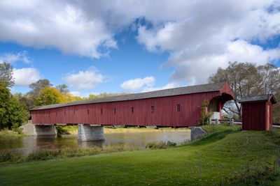
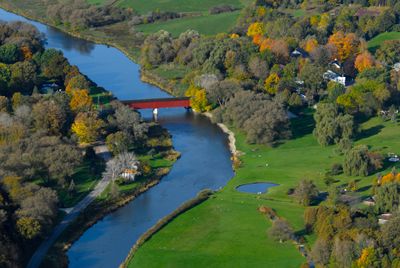
West Montrose Covered Bridge, Covered road bridge in West Montrose, Canada.

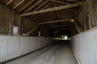
The West Montrose Covered Bridge is a roofed road crossing with red wooden walls and a gabled roof spanning 60 meters across the Grand River. The interior is bright and open, with narrow lanes for vehicles and walking paths along both sides.

The structure was built in 1881 by local carpenters John and Benjamin Bear following approval from Woolwich Township Council. It was constructed to replace an earlier crossing and is now designated as a heritage property.

The bridge earned its 'Kissing Bridge' nickname from a local custom where couples would stop to kiss while crossing the wooden structure. This romantic tradition has become part of the community's identity and continues to draw visitors.

Vehicles under three tons can cross daily, while pedestrians have designated walkways on both sides of the structure. The narrow interior space means traffic must move slowly and carefully when vehicles meet.

This is Ontario's last covered bridge still in regular use for vehicle traffic across the Grand River. Its continuing operation in working condition makes it a living example of a nearly extinct building method.

The community of curious travelers

AroundUs brings together thousands of curated places, local tips, and hidden gems, enriched daily by 60,000 contributors worldwide.

Start exploring
Location
Inception
1881
Official opening
1881
Length
60 m
Address
Hill Street/Rivers Edge Drive (West Montrose)
GPS coordinates
43.58557,-80.48147
Latest update
December 8, 2025 19:53
« West Montrose Covered Bridge - Covered road bridge in West Montrose, Canada » is provided by Around Us (aroundus.com). Images and texts are derived from Wikimedia project under a Creative Commons license. You are allowed to copy, distribute, and modify copies of this page, under the conditions set by the license, as long as this note is clearly visible.

Discover hidden gems everywhere you go!

From secret cafés to breathtaking viewpoints, skip the crowded tourist spots and find places that match your style. Our app makes it easy with voice search, smart filtering, route optimization, and insider tips from travelers worldwide. Download now for the complete mobile experience.

Around Us App Screenshot

A unique approach to discovering new places

Le Figaro

All the places worth exploring

France Info

A tailor-made excursion in just a few clicks

20 Minutes

Around Us
Travel Guide & Maps
Download

Send to your phone

QR Code
1

Open the camera app on your mobile.

2

Point at the QR code with your camera. A notification will appear.

3

Tap the notification to open the link.