Margelchopf, Mountain summit in Canton St. Gallen, Switzerland
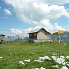
Margelchopf is a 2,163-metre summit in the Alvier group in the Swiss canton of St. Gallen, the highest point of the group's northeasternmost side chain. Its summit is a grassy plateau almost 100 metres long, running northwest to southeast and ringed by a rock belt that drops steeply to the north. Only the southern side is easy to reach.
The Margelchopf is the local mountain of the people of Grabs and the highest point of the northeasternmost side chain of the Alvier group. Its easiest ascent, rated T2 on the SAC hiking scale, leads from Buchser Malbun over the Sisitzgrat from the south; the northwest ridge is a T4 route with climbing sections. In winter, ski tourers use the Sisitzgrat for a detour to the summit when snow is scarce.
Grabs residents call Margelchopf their local mountain, and its grassy summit plateau, nearly 100 m long, is ringed by a rock belt that drops steeply to the north. In winter, ski tourers use low-snow conditions to make a detour from the Sisitzgrat to the summit.
The ascent is manageable for hikers with moderate fitness, though good mountain boots are recommended for the terrain. Visitors should be prepared for changing weather, as conditions at the summit can shift quickly even in summer.
The summit plateau is a grassy area almost 100 metres long, running northwest to southeast and ringed on all sides by a rock belt that drops steeply to the north. Only the southern side gives easy access, which is why the T2 route arrives over the Sisitzgrat from Buchser Malbun.
The community of curious travelers
AroundUs brings together thousands of curated places, local tips, and hidden gems, enriched daily by 93,809 contributors worldwide.