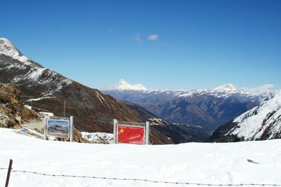
Nathu La, Mountain pass at China-India border, Tibet
Nathu La is a boundary point and mountain pass at 14,140 feet (4,310 meters) elevation in the Dongkya Range, linking Tibet's Yadong County with India's Sikkim state. The crossing remains closed during winter months due to heavy snowfall and shows a bare landscape of rock, ice and thin air around the marker line between both countries.
The crossing opened in 1873 for formal trade between Tibet and what was then British India, remaining a main corridor for wool, salt and tea until 1962. The war between China and India that year led to its closure, which lifted only partly in 2006 and has since allowed access on limited days for specific travelers.
The Tibetan name means listening ears and points to the alertness old traders kept toward avalanches and rockfalls in these narrow valleys. Pilgrims and herders used this route for centuries, shaping a connection between highland cultures on either side of the ridge.
Visitors on the Indian side need permits arranged through approved agencies or government offices, as the area remains under military restriction. The extreme altitude demands slow movement and enough time to adjust, preventing breathing trouble and headaches.
The border station operates as one of five formal meeting points where military personnel from both countries gather regularly and hold flag ceremonies. Stone walls and concrete markers define the exact boundary line, which becomes visible to only a few civilians at this remote altitude.
The community of curious travelers
AroundUs brings together thousands of curated places, local tips, and hidden gems, enriched daily by 60,000 contributors worldwide.