Obelisk am Karolinenplatz
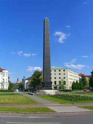
Obelisk am Karolinenplatz, War memorial obelisk in Maxvorstadt district, Munich, Germany
The black obelisk at Karolinenplatz rises approximately 29 meters above a three-tiered marble base situated in the center of the square. The structure combines brick construction with marble cladding and bronze elements to create a solemn monument.
King Ludwig I commissioned architect Leo von Klenze in 1833 to design this memorial to honor 30,000 Bavarian soldiers killed during Napoleon's Russian campaign. The project reshaped the urban character of the city as a permanent reminder of wartime losses.
The bronze plaques were cast from captured cannons and bear the names of soldiers who fell in battle. These inscriptions tell a story of loss that residents and visitors see as part of the city's collective memory.
The site sits at the intersection of Brienner Straße and Barer Straße, served by multiple tram lines that circle the square. This central location makes it easy to reach and simple to include in any walking route through the area.
The square was intentionally designed to mirror the radial layout of Paris's famous plazas, with streets spreading outward from the center. This represented Munich's first attempt to replicate the European model of a hub-and-spoke urban design.
Location: Munich
Inception: October 18, 1833
Architects: Leo von Klenze
Height: 29 m
Made from material: bronze, marble, brick
Address: Karolinenplatz
GPS coordinates: 48.14469,11.56918
Latest update: December 8, 2025 19:42
Führerbau
187 m
Wittelsbacher Palace
233 m
NS-Dokumentationszentrum
141 m
State Museum of Egyptian Art
264 m
Brienner Straße
129 m
Münchner Haus der Kulturinstitute
193 m
Staatliche Graphische Sammlung München
209 m
Amerikahaus München
103 m
Museum für Abgüsse Klassischer Bildwerke
182 m
Prinz-Georg-Palais
83 m
Staatssammlung für Anthropologie und Paläoanatomie München
78 m
Staatsbauschule München
202 m
Palais Degenfeld
139 m
Palais Berchem
194 m
Brienner Straße 28 (München)
103 m
Brienner Straße 25
154 m
Brienner Straße 23
184 m
Karlstraße 18
249 m
Bayerische Landesbausparkasse
84 m
Ehemaliges Nebengebäude des abgebrochenen Asbeck- Palais, später Lotzbeck-Galerie
76 m
Staatliche Lottoverwaltung
87 m
Ehem. Palais Schrenck-Notzing, jetzt Bayerischer Bauernverband
98 m
Ottostraße 17
220 m
Prinz-Ludwig-Straße 9
146 m
Brienner Straße 26
131 m
Palais Berchem, jetzt Verwaltungsgebäude der Bayerischen Landesbank
200 m
Mietshaus
258 m
Prinz-Ludwig-Straße 7
156 mVisited this place? Tap the stars to rate it and share your experience / photos with the community! Try now! You can cancel it anytime.
Discover hidden gems everywhere you go!
From secret cafés to breathtaking viewpoints, skip the crowded tourist spots and find places that match your style. Our app makes it easy with voice search, smart filtering, route optimization, and insider tips from travelers worldwide. Download now for the complete mobile experience.
A unique approach to discovering new places❞
— Le Figaro
All the places worth exploring❞
— France Info
A tailor-made excursion in just a few clicks❞
— 20 Minutes