Buer Berg, Volcanic hill in the Eifel, Rhineland-Palatinate, Germany
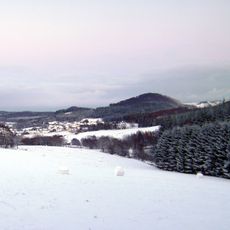
The Burberg, also called Buerberg or Bürberg, is a 528.5 m high hill in the Eifel, rising in the Volcanic Eifel Nature Park and the Hinterbüsch. The village of Schutz lies at its southeastern foot, on whose territory the hill stands; the Walmerbach flows past to the west and empties into the Kleine Kyll. Remains of a 4th-century Roman fortification lie on the summit region.
The Burberg is a volcanic cone formed about 11,000 years ago, not a folded slate peak. On its summit area are the remains of a Roman fortification from the 4th century AD. The hill lies in the Kyllburger Waldeifel, in the Salmer Hügelland sub-unit of the East Eifel.
The hill lies in the Hinterbüsch within the Volcanic Eifel Nature Park, and its slopes belong to the protected landscape Zwischen Ueß und Kyll, designated in 1982 and covering 396.2312 km². The villages of Schutz at the southeastern foot and Weidenbach, 3.1 km west-southwest of the summit, are the nearest settlements. The Walmerbach flows past the western side and empties into the Kleine Kyll near Schutz.
The summit lies within the Zwischen Ueß und Kyll protected landscape, designated in 1982 and covering 396.23 km². The village of Schutz sits at the southeastern foot of the hill, and the Walmerbach flows past its western side before joining the Kleine Kyll. Approach from Schutz; the summit area holds the Roman fortification remains.
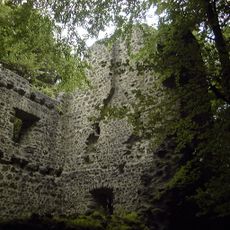
The summit area holds remains of a Roman fortification from the 4th century AD, a detail easy to miss among the trees. The hill itself is a volcano formed about 11,000 years ago, and since 1982 it has lain within the 396 km² Zwischen Ueß und Kyll protected landscape.
The community of curious travelers
AroundUs brings together thousands of curated places, local tips, and hidden gems, enriched daily by 94,419 contributors worldwide.