Enable Location

We need your location to show you interesting places around you

Discover nearby places

Find interesting locations and hidden gems around you

Precise directions

Get accurate directions and distances to places

Your location is never shared with other users. It's only used when you tap the location button.

Hochbunker Friedrich-Karl-Straße

Log in to your account

Start exploring — it's free

Trusted by 61,607 travelers worldwide

Continue with Google
Continue with Apple
or

We will send you a code to connect

By continuing, you accept our Terms and Conditions and our Privacy Policy

Check your inbox

We've sent a pincode in your inbox. Please enter the code below.

Hochbunker Friedrich-Karl-Straße

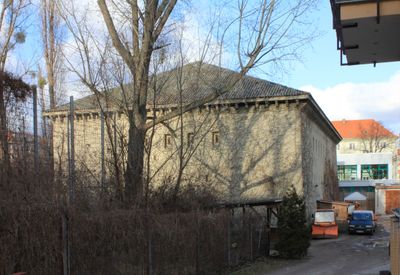
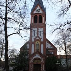
Hochbunker Friedrich-Karl-Straße, M500 type bunker in Tempelhof-Schöneberg, Germany.

Description

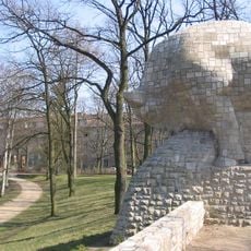
The Hochbunker Friedrich-Karl-Straße is a rectangular civil air raid shelter standing 18 meters tall, measuring 15 meters wide and 32 meters long. Its walls taper from bottom to top, and it features two rounded entrances framed in artificial stone plus an accessible rooftop level.

History

Construction began after the first Royal Air Force attacks on Berlin in August 1940 as part of emergency defense planning during the war. The design was created specifically to protect Berlin's civilian population during the air campaign that would intensify in the following years.

Culture

Today the building houses soundproof rehearsal spaces where local musicians practice and create their work in a repurposed setting. This use by artists has given the structure a new cultural purpose that reaches far beyond its original design.

Practical

The bunker sits at Friedrich-Karl-Straße 24 in the middle of a residential block bounded by Burgemeisterstraße, Werderstraße, and Friedrich-Franz-Straße. The accessible rooftop provides easy viewing of the structure's exterior without needing special arrangements or permission.

Did you know?

This is one of only a few M500 structures still standing in Berlin, a specialized bunker design from the wartime period. The rarity of this building type makes it an important example of early 1940s air defense architecture.

GPS coordinates
52.45678,13.37942
Latest update
December 13, 2025 17:04

AroundUs brings together thousands of curated places, local tips, and hidden gems, enriched daily by 60,000 contributors worldwide. Discover all places nearby (Tempelhof-Schöneberg).

« Hochbunker Friedrich-Karl-Straße - M500 type bunker in Tempelhof-Schöneberg, Germany » is provided by Around Us (aroundus.com). Images and texts are derived from Wikimedia project under a Creative Commons license. You are allowed to copy, distribute, and modify copies of this page, under the conditions set by the license, as long as this note is clearly visible.

Discover hidden gems everywhere you go!

From secret cafés to breathtaking viewpoints, skip the crowded tourist spots and find places that match your style. Our app makes it easy with voice search, smart filtering, route optimization, and insider tips from travelers worldwide. Download now for the complete mobile experience.

Around Us App Screenshot

A unique approach to discovering new places

Le Figaro

All the places worth exploring

France Info

A tailor-made excursion in just a few clicks

20 Minutes

Around Us
Travel Guide & Maps
Download

Send to your phone

QR Code
1

Open the camera app on your mobile.

2

Point at the QR code with your camera. A notification will appear.

3

Tap the notification to open the link.