Bunker in Braunschweig, Air raid shelter network in Braunschweig, Germany
The bunker network in Braunschweig comprises 24 public shelters made of reinforced concrete, distributed across different neighborhoods with varying sizes and capacities. The structures display sturdy construction with thick walls and reinforced ceilings, typical of air raid shelter architecture from that period.
Construction began in 1940 when Braunschweig received priority due to its role as a research and armament center. The facilities were expanded over the following years to handle the growing population and increased air raids targeting the city.
The bunkers served as central gathering places for the community during wartime and later became homes, storage facilities, and civil defense centers. They show how people adapted to emergency living and how structures can shift their purpose entirely after conflict.
Many bunkers today are not open to the public as they have been converted into private apartments or business spaces. It is wise to check with local museums or historical societies about guided visits or information on which locations are accessible.
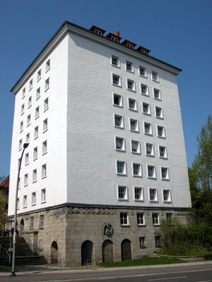
The largest one on Madamenweg was designed for around 1,500 people and showcased advanced engineering techniques of that building phase. The precise planning of this facility is documented today through preserved blueprints, which reveal the safety standards of the time.
The community of curious travelers
AroundUs brings together thousands of curated places, local tips, and hidden gems, enriched daily by 60,000 contributors worldwide.