Kantili, Mountain summit in Mantoudi-Limni-Agia Anna, Greece
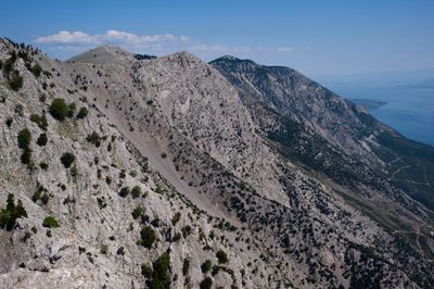
Kantili is a mountain range in the northwestern part of Euboea, reaching 1,246 m at its highest point. It runs about 25 km from southeast to northwest along the west coast, above the North Euboean Gulf between Limni and Politika. The seaward slope is very steep, with no road along the coast, while the eastern side is covered with Aleppo pine, black pine and Cephalonian fir; mines operate at the northern and eastern edge, and to the south the range joins Dirfys.
Kantili takes its name from the Greek word for candle, and the mountain's documented record is one of land use rather than settlement: the Greek Mountaineering Association of Chalcis marks hiking routes on its slopes, and working mines operate at its northern and eastern edges. The range runs about 25 km between Limni and Politika, with National Road 77 passing to its east.
Local people call the peak Kourouvlo, a traditional name that shows how closely the nearby community connects with this mountain. The villagers of Troupi use this name in daily speech, keeping alive their personal link to the landscape.
The range runs about 25 km along the coast between Limni and Politika, and its seaward slope is so steep that no road follows the shore. The Greek National Road 77 (Chalcis–Istiaia) passes east of the mountains, so access is from the inland side. Hiking routes on Kandili, including from Makistos, are maintained by the Chalcis Mountaineering Club (E.O.S. Chalcis).
The mountain forms a natural barrier along the coast that prevented the construction of coastal roads and left the surroundings undeveloped. This kept this stretch of Euboea more untouched and natural compared to other coastal areas in the region.
The community of curious travelers
AroundUs brings together thousands of curated places, local tips, and hidden gems, enriched daily by 94,654 contributors worldwide.