Lac Bleu de Lesponne, Mountain lake in Hautes-Pyrénées, France
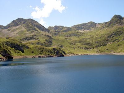
Lac Bleu de Lesponne covers 52 hectares at an elevation of 1977 meters, surrounded by rocky slopes and alpine meadows.
The lake formed through glacial activity that carved the landscape of the Hautes-Pyrénées over thousands of years.
Pyrenean shepherds have used the paths around the lake for generations to maintain their traditional pastoral activities.
Access to the lake requires a two-and-a-half-hour hike from Le Chiroulet, with significant elevation gain on marked trails.
At 135 meters deep, this lake stands as the deepest natural reservoir in the Pyrenees mountain range.
Location: Hautes-Pyrénées
Elevation above the sea: 1,977 m
Address: Lac Bleu de Lesponne, 65400 Beaucens, France 65400 Beaucens
GPS coordinates: 42.93672,0.08017
Latest update: July 1, 2025 15:29
Occitanie hosts a wide variety of lakes spread between the Pyrenees and the Massif Central. Natural lakes mainly occupy high-altitude zones in the Pyrenees, where glacial erosion has carved out cirques and basins now filled with water. Lake Oô, located at 4,950 feet (1,507 meters) altitude, receives water from a 984-foot (300-meter) waterfall descending from Lake Espingo. The Bastan lakes form a series of three linked water bodies between 7,217 and 8,202 feet (2,200 and 2,500 meters) near Barèges, while Lake Bethmale, at 3,498 feet (1,065 meters) in Couserans, is surrounded by beech forests. Artificial lakes in the region serve various functions, including water storage, hydroelectric power, and recreational activities. Lake Salagou, created in 1969 in Herault, stands out for its distinctive geological setting: red rocks rich in iron give the landscape a reddish-brown hue. Lake Pareloup, covering about 3,485 acres (1,410 hectares) in Aveyron, is one of the largest reservoirs in the area. Lake Saint-Ferréol, built in the 17th century at the foot of the Black Mountain, supplies the Canal du Midi and demonstrates historic hydraulic engineering. These lakes offer opportunities for hiking, sailing, and windsurfing, especially at Lake Ganguise where the wind blows roughly 300 days per year.
Pic du Midi de Bigorre
5 km
Col du Tourmalet
6.2 km
Téléphérique du pic du Midi de Bigorre
8.6 km
Émetteur du pic du Midi de Bigorre
5 km
Station thermale de Barèges
4.5 km
Pic du Midi Observatory
5 km
Château de Sainte-Marie
9.4 km
Pic du Montaigu
5.3 km
Le Géant
6.1 km
Jardin botanique du Tourmalet
6.2 km
Chapelle Notre-Dame de La Mongie
8.4 km
Pigeonnier de Chèze
9.5 km
Église Saint-Nicolas d'Esquièze
9.5 km
Église des templiers, Luz-Saint-Sauveur
10 km
Église Saint-Jean-Baptiste de Sère
9.6 km
Église Saint-Vincent de Sers
6.5 km
Église Saint-Michel de Viella
8.6 km
Église Saint-Barthélémy de Chèze
9.7 km
Église Saint-Pierre-et-Saint-Paul de Saligos
9.6 km
Église Saint-Laurent de Barèges
4.6 km
Église Saints-Anges-Gardiens de Lesponne
9.1 km
Église Saint-Sylvestre de Viey
7.6 km
ÉgIise Saint-Michel de Vizos
9.3 km
Église Saint-Étienne d'Esterre
9.1 km
Église Saint-Sébastien de Betpouey
7.2 km
Prieuré de Saint-Orens-en-Lavedan
9.5 km
Chapelle Notre-Dame-des-Lacs de Lesponne
2.8 km
Chapelle Notre-Dame-de-la-Pitié de Villenave
9.8 kmReviews
Visited this place? Tap the stars to rate it and share your experience / photos with the community! Try now! You can cancel it anytime.
Discover hidden gems everywhere you go!
From secret cafés to breathtaking viewpoints, skip the crowded tourist spots and find places that match your style. Our app makes it easy with voice search, smart filtering, route optimization, and insider tips from travelers worldwide. Download now for the complete mobile experience.
A unique approach to discovering new places❞
— Le Figaro
All the places worth exploring❞
— France Info
A tailor-made excursion in just a few clicks❞
— 20 Minutes