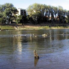
Cibakháza Tisza-Backwater, Backwater system near Cibakháza, Hungary.
Cibakháza Tisza-Backwater is a roughly U-shaped dead arm of the Tisza, 16.886 km long, with an average width of 139.1 m and an average depth of 2.65 m. It lies on the protected side of the left-bank flood embankment, mostly in Cibakháza and partly in Nagyrév. Its sections carry names such as Kistorok, Szakadás, Pipagyújtó, Partalja, Árvád, Kisörvény, Versenypálya, Dora, Nagyörvény, Jégverem, Haskó, Kavics and Nagytorok; the deepest point, in Nagyörvény, exceeds 7 m.
The backwater was created artificially in 1856 during the regulation of the Tisza, when cut no. 78 severed a large bend. The engineer Paleocapa had advised in 1846 against this cut, fearing Cibakháza would lose its crossing role; the cut went ahead and the town later lost its urban rank.
The sections of the backwater carry names used by local anglers, such as Kistorok, Szakadás, Pipagyújtó, Partalja, Árvád, Kisörvény, Versenypálya, Dora, Nagyörvény, Jégverem, Haskó, Kavics and Nagytorok. The Cibakházi Vegyesüzemi Horgász Egyesület holds its own competitions on the Versenypálya stretch and runs an annual fishing camp for dozens of schoolchildren.
The backwater is easiest to reach from the 4633 road between Martfű and Cserkeszőlő, which passes through central Cibakháza and runs along the bank for a stretch. The Nagyrév sections are reached from the 46 146 side road, which also follows the shoreline in places. Anglers need a permit from the Cibakházi Vegyesüzemi Horgászegyesület, which issues annual, daily and two-day permits.
The backwater was created in 1856 by cut No. 78 during the Tisza regulation. Engineer Paleocapa had advised against this cut in his 1846 work on the Tisza valley, fearing Cibakháza would end up far from the river; the cut went ahead and the village lost its river-crossing role.
The community of curious travelers
AroundUs brings together thousands of curated places, local tips, and hidden gems, enriched daily by 94,455 contributors worldwide.