Enable Location

We need your location to show you interesting places around you

Discover nearby places

Find interesting locations and hidden gems around you

Precise directions

Get accurate directions and distances to places

Your location is never shared with other users. It's only used when you tap the location button.

Log in to your account

Start exploring — it's free

Trusted by 63,295 travelers worldwide

Continue with Google
Continue with Apple
or

We will send you a code to connect

By continuing, you accept our Terms and Conditions and our Privacy Policy

Check your inbox

We've sent a pincode in your inbox. Please enter the code below.

Rajouri district
Discussion Reviews Photo
32.3k Popularity

Rajouri district, Administrative district in Jammu division, India

Rajouri is an administrative district in Jammu division that stretches across mountainous regions and fertile valleys. The landscape sits at about 915 meters in elevation and experiences a moderate climate varying between 8 and 23 degrees Celsius.

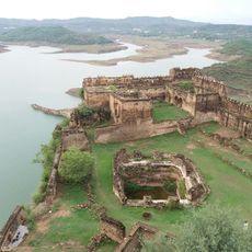
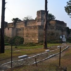
This region emerged as an ancient principality under Raja Prithvi Pal of the Mangral Rajput clan, who ruled from 1033 to 1192. During that period, the kingdom guarded the Pir Panchal Pass, a strategically important mountain crossing.

Two language communities, Pahari and Gojri speakers, shape daily life here alongside different religious traditions. This mix of languages and beliefs creates a diverse social fabric visible in how people interact.

Travel to the area is easiest along the Poonch Highway, which connects it to larger cities. Jammu Airport serves as the nearest air terminal, with Jammu itself about 150 kilometers away and Srinagar about 155 kilometers to the north.

The district is home to Baba Ghulam Shah Badshah University, a significant educational institution for the region. Its position near the border with Pakistan's Azad Kashmir shapes much of the political and social context of life here.

The community of curious travelers

AroundUs brings together thousands of curated places, local tips, and hidden gems, enriched daily by 60,000 contributors worldwide.

Start exploring
Location
Capital city
Rajauri
Shares border with
Kulgam district, Reasi district
GPS coordinates
33.25000,74.25000
Latest update
December 20, 2025 00:32
Reviews
Share your experience

No review yet

Discussions
Start a discussion...

No discussion yet

« Rajouri district - Administrative district in Jammu division, India » is provided by Around Us (aroundus.com). Images and texts are derived from Wikimedia project under a Creative Commons license. You are allowed to copy, distribute, and modify copies of this page, under the conditions set by the license, as long as this note is clearly visible.

Discover hidden gems everywhere you go!

From secret cafés to breathtaking viewpoints, skip the crowded tourist spots and find places that match your style. Our app makes it easy with voice search, smart filtering, route optimization, and insider tips from travelers worldwide. Download now for the complete mobile experience.

Around Us App Screenshot

A unique approach to discovering new places

Le Figaro

All the places worth exploring

France Info

A tailor-made excursion in just a few clicks

20 Minutes

Around Us
Travel Guide & Maps
Download

Send to your phone

QR Code
1

Open the camera app on your mobile.

2

Point at the QR code with your camera. A notification will appear.

3

Tap the notification to open the link.