Enable Location

We need your location to show you interesting places around you

Discover nearby places

Find interesting locations and hidden gems around you

Precise directions

Get accurate directions and distances to places

Your location is never shared with other users. It's only used when you tap the location button.

Oyama

Log in to your account

Start exploring — it's free

Trusted by 61,965 travelers worldwide

Continue with Google
Continue with Apple
or

We will send you a code to connect

By continuing, you accept our Terms and Conditions and our Privacy Policy

Check your inbox

We've sent a pincode in your inbox. Please enter the code below.

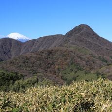
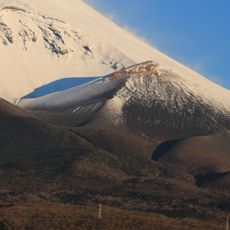
Oyama, Administrative town in Sunto District, Japan

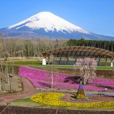
Oyama is a town in Sunto District nestled between the Tanzawa Mountains and Mount Fuji foothills, home to several thousand residents. The landscape is defined by mountainous terrain and dense forests that shape the character of the settlement.

The area began as a post town during the Heian period and remained under the direct control of the Tokugawa shogunate throughout the Edo period. This long connection to central authority shaped how the settlement developed and was organized.

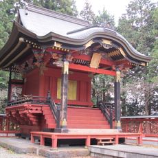
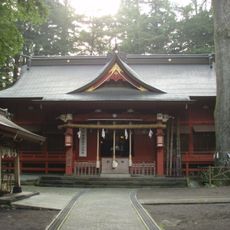
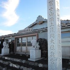
The Higashiguchi Hongu Fuji Sengen Shrine anchors community life and ties residents to Mount Fuji through regular worship and local celebrations. This sacred site shapes how people see their town as a place of reverence and tradition.

Visitors can access Suruga-Oyama Station, which runs regular train services connecting to larger networks beyond the town. The proximity to the expressway also makes driving a viable way to arrive.

The town sits at an average elevation of 800 meters, which creates a noticeably cooler climate than lower regions. This height allows forests to flourish and cover about two-thirds of the territory, keeping the air fresh.

The community of curious travelers

AroundUs brings together thousands of curated places, local tips, and hidden gems, enriched daily by 60,000 contributors worldwide.

Start exploring
Location
Inception
August 1, 1912
Reference
223441
Shares border with
Gotemba, Fujinomiya, Minamiashigara, Hakone, Yamakita, Fujiyoshida, Yamanakako, Narusawa
GPS coordinates
35.36008,138.98728
Latest update
December 17, 2025 10:06
« Oyama - Administrative town in Sunto District, Japan » is provided by Around Us (aroundus.com). Images and texts are derived from Wikimedia project under a Creative Commons license. You are allowed to copy, distribute, and modify copies of this page, under the conditions set by the license, as long as this note is clearly visible.

Discover hidden gems everywhere you go!

From secret cafés to breathtaking viewpoints, skip the crowded tourist spots and find places that match your style. Our app makes it easy with voice search, smart filtering, route optimization, and insider tips from travelers worldwide. Download now for the complete mobile experience.

Around Us App Screenshot

A unique approach to discovering new places

Le Figaro

All the places worth exploring

France Info

A tailor-made excursion in just a few clicks

20 Minutes

Around Us
Travel Guide & Maps
Download

Send to your phone

QR Code
1

Open the camera app on your mobile.

2

Point at the QR code with your camera. A notification will appear.

3

Tap the notification to open the link.