Enable Location

We need your location to show you interesting places around you

Discover nearby places

Find interesting locations and hidden gems around you

Precise directions

Get accurate directions and distances to places

Your location is never shared with other users. It's only used when you tap the location button.

Toktogul Dam

Log in to your account

Start exploring — it's free

Trusted by 68,050 travelers worldwide

Continue with Google
Continue with Apple
or

We will send you a code to connect

By continuing, you accept our Terms and Conditions and our Privacy Policy

Check your inbox

We've sent a pincode in your inbox. Please enter the code below.

Toktogul Dam
Discussion Reviews 1 Photos
16.6k Popularity

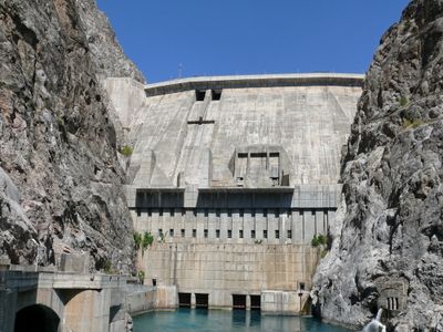
Toktogul Dam, Hydroelectric power station in Jalal-Abad Region, Kyrgyzstan.

Toktogul Dam is a concrete structure spanning over 290 meters along the Naryn River, reaching about 215 meters in height. It operates with four large turbines to generate electricity and holds a substantial water reservoir behind its wall.

Construction began in 1960, with the first turbines starting to generate power between 1975 and 1976. It emerged as part of broader energy development efforts in the Soviet Union during the postwar period.

The structure bears the name of musician Toktogul Satilganov, connecting engineering with national identity for local people. It shapes the landscape and represents part of how residents relate to their geographic and cultural surroundings.

The site sits in a mountainous valley subject to earthquakes, so sturdy footwear and caution are recommended when exploring. It is best visited during daylight hours when views of the structure and reservoir are clearest.

The structure was specifically engineered to withstand strong earthquakes, as the region sits in a seismically active zone. This engineering feat makes it one of the most resilient technical structures against natural forces in Central Asia.

The community of curious travelers

AroundUs brings together thousands of curated places, local tips, and hidden gems, enriched daily by 60,000 contributors worldwide.

Start exploring
Inception
1956
Length
292.5 m
GPS coordinates
41.65697,72.63625
Latest update
December 7, 2025 19:26
Around this place
Kempir-Abad reservoir
Kyrgyzstan

Kempir-Abad reservoir

106.2 km
Saimaluu-Tash
Kyrgyzstan

Saimaluu-Tash

111.8 km
Toktogul Reservoir
Kyrgyzstan

Toktogul Reservoir

25.8 km
Sary-Chelek Nature Reserve
Kyrgyzstan

Sary-Chelek Nature Reserve

58.9 km
Manas Ordo
Kyrgyzstan

Manas Ordo

98.9 km
Uzgen Minaret
Kyrgyzstan

Uzgen Minaret

113.6 km
Kyrgyzstan

Padyshata State Nature Reserve

88.3 km
Church in Andijan
Uzbekistan

Church in Andijan

102.9 km
Church of St. Archangel Michael in Namangan 1894
Uzbekistan

Church of St. Archangel Michael in Namangan 1894

109.1 km
Church of St. Archangel Michael in Namangan 1952
Uzbekistan

Church of St. Archangel Michael in Namangan 1952

107.9 km
Church of St. Nicholay Chudotvortsa in Andijan
Uzbekistan

Church of St. Nicholay Chudotvortsa in Andijan

102.9 km
Chapel of St. George in Andijan
Uzbekistan

Chapel of St. George in Andijan

102.4 km
Mausoleen von Ösgön
Kyrgyzstan

Mausoleen von Ösgön

113.4 km
Church of St. Sergiy Radonezhckogo in Andijan
Uzbekistan

Church of St. Sergiy Radonezhckogo in Andijan

102.4 km
Kyrgyzstan

Ak-Kur

40.5 km
Shah Fazil Mausoleum
Kyrgyzstan

Shah Fazil Mausoleum

85.3 km
Kyrgyzstan

Rodnik Kara-Bulak (tubud sa Kirgistan, Jalal-Abad oblast, lat 41,17, long 72,69)

54.8 km
Kyrgyzstan

Rodnik Sasyk-Bulak (tubud sa Kirgistan, Jalal-Abad oblast, lat 41,14, long 72,81)

59.4 km
Kyrgyzstan

Akkurgan

39.4 km
Kyrgyzstan

Rodnik Burzhu-Bulak

62.3 km
Kyrgyzstan

Rodnik Kyzyl-Alma

46.8 km
Kyrgyzstan

Rodnik Sasyk-Bulak (tubud sa Kirgistan, Jalal-Abad oblast, lat 41,25, long 72,90)

50.8 km
Kyrgyzstan

Rodnik Kara-Suu

106.7 km
Kyrgyzstan

Rodnik Kara-Bulak (tubud sa Kirgistan, Jalal-Abad oblast, lat 41,61, long 71,99)

54.1 km
Kyrgyzstan

Rodnik Kosh-Bulak

54.9 km
Kyrgyzstan

Rodnik Ak-Tash (tubud sa Kirgistan, Jalal-Abad oblast)

50 km
Kyrgyzstan

Rodnik Kayragach-Bulak

55.7 km
Kyrgyzstan

Rodnik Tashbulak (tubud sa Kirgistan, Talas)

116.8 km
Show the full map
Reviews
Share your experience

No review yet

Discussions
Start a discussion...

No discussion yet

« Toktogul Dam - Hydroelectric power station in Jalal-Abad Region, Kyrgyzstan » is provided by Around Us (aroundus.com). Images and texts are derived from Wikimedia project under a Creative Commons license. You are allowed to copy, distribute, and modify copies of this page, under the conditions set by the license, as long as this note is clearly visible.

Discover hidden gems everywhere you go!

From secret cafés to breathtaking viewpoints, skip the crowded tourist spots and find places that match your style. Our app makes it easy with voice search, smart filtering, route optimization, and insider tips from travelers worldwide. Download now for the complete mobile experience.

Around Us App Screenshot

A unique approach to discovering new places

Le Figaro

All the places worth exploring

France Info

A tailor-made excursion in just a few clicks

20 Minutes

Around Us
Travel Guide & Maps
Download

Send to your phone

QR Code
1

Open the camera app on your mobile.

2

Point at the QR code with your camera. A notification will appear.

3

Tap the notification to open the link.