Enable Location

We need your location to show you interesting places around you

Discover nearby places

Find interesting locations and hidden gems around you

Precise directions

Get accurate directions and distances to places

Your location is never shared with other users. It's only used when you tap the location button.

Nizhnekamsk Reservoir

Log in to your account

Start exploring — it's free

Trusted by 62,410 travelers worldwide

Continue with Google
Continue with Apple
or

We will send you a code to connect

By continuing, you accept our Terms and Conditions and our Privacy Policy

Check your inbox

We've sent a pincode in your inbox. Please enter the code below.

Nizhnekamsk Reservoir

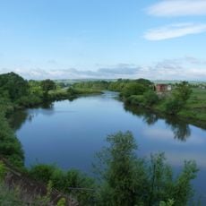
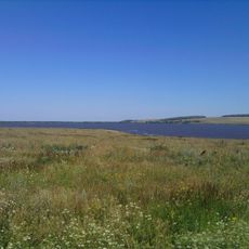
Nizhnekamsk Reservoir, reservoir in Russia

Nizhnekamsk Reservoir is a large body of water spanning Tatarstan, Bashkortostan, and Udmurtia, held back by a massive dam across the Kama River. It covers approximately 1,084 square kilometers and supplies electricity, water for agriculture and industry, and recreation opportunities to the region.

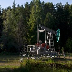
The reservoir formed between 1978 and 1981 with construction of the Nizhnekamsk Dam, a major Soviet-era infrastructure project. The dam was part of a broader strategy to supply power and support rapid industrial development in the region, especially the KAMAZ truck factory in Naberezhnye Chelny.

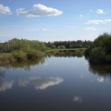
The reservoir is a gathering place for local fishermen and residents who spend leisure time here and use the waters for daily needs. The shoreline shapes life in nearby towns, especially Naberezhnye Chelny, where the water body is closely tied to the rhythm of industrial workers.

Access is best from Naberezhnye Chelny and nearby towns, where walking paths and public areas run along the dam. Visitors should prepare for changing water levels and weather conditions that may affect accessibility to certain areas.

The dam functions as a lock for ships traveling on the Kama River, offering visitors the rare sight of large vessels passing through a narrow channel. This overlooked aspect of the structure reveals how the dam merges navigation and water management in a single engineering solution.

The community of curious travelers

AroundUs brings together thousands of curated places, local tips, and hidden gems, enriched daily by 60,000 contributors worldwide.

Start exploring
Location
Location
Location
Elevation above the sea
68 m
GPS coordinates
55.88333,52.75000
Latest update
February 7, 2026 11:01
Around this place
Ik
Russian Federation

Ik

44.5 km
Tübän Kama National Park
Russian Federation

Tübän Kama National Park

28.2 km
Izh
Russian Federation

Izh

19.6 km
KAMAZ Stadium
Russian Federation

KAMAZ Stadium

26.7 km
Church of the Ascension of Christ
Russian Federation

Church of the Ascension of Christ

23.7 km
Nadezhda Durova Estate, Elabuga
Russian Federation

Nadezhda Durova Estate, Elabuga

44.9 km
Russian Federation

Regional Historical Museum Naberezhnye Chelny

36 km
Täwbä Mosque, Çallı
Russian Federation

Täwbä Mosque, Çallı

34 km
Cathedral of the Holy Mandylion, Elabuga
Russian Federation

Cathedral of the Holy Mandylion, Elabuga

45.7 km
Stroitel Stadium
Russian Federation

Stroitel Stadium

36 km
Dolphinarium in Naberezhnye Chelny
Russian Federation

Dolphinarium in Naberezhnye Chelny

36.6 km
Russian Federation

Ivan Shishkin's House Museum

45.8 km
Menzelya
Russian Federation

Menzelya

29.6 km
Church of Saints Cosmas and Damian
Russian Federation

Church of Saints Cosmas and Damian

30.5 km
Naberezjnotsjelninskiy gosoedarstvenniy tatarskiy dramatitsjeskiy teatr
Russian Federation

Naberezjnotsjelninskiy gosoedarstvenniy tatarskiy dramatitsjeskiy teatr

26.5 km
Church of the Protection of the Theotokos, Elabuga
Russian Federation

Church of the Protection of the Theotokos, Elabuga

44.9 km
Elabuzhsky Monastery
Russian Federation

Elabuzhsky Monastery

44 km
Ananʹinskiĭ Mound
Russian Federation

Ananʹinskiĭ Mound

42.9 km
Russian Federation

Совхоза Татарстан

30.8 km
Russian Federation

Яр Чаллы картиналар галереясы

26.5 km
Дом-музей Ашальчи Оки
Russian Federation

Дом-музей Ашальчи Оки

37.4 km
Мемориальный комплекс М. И. Цветаевой
Russian Federation

Мемориальный комплекс М. И. Цветаевой

44.8 km
Гиндукуш
Russian Federation

Гиндукуш

38.6 km
Palace of Culture Energetik
Russian Federation

Palace of Culture Energetik

36 km
Railway bridge in Menzelinsk
Russian Federation

Railway bridge in Menzelinsk

30.6 km
Saint Nicholas Church (Elabuga)
Russian Federation

Saint Nicholas Church (Elabuga)

45.3 km
Тереклек бирүче Өчле гыйбадәтханәсе
Russian Federation

Тереклек бирүче Өчле гыйбадәтханәсе

36.6 km
Церковь Николая Чудотворца (Новопоселенное)
Russian Federation

Церковь Николая Чудотворца (Новопоселенное)

40.3 km
Show the full map
« Nizhnekamsk Reservoir - reservoir in Russia » is provided by Around Us (aroundus.com). Images and texts are derived from Wikimedia project under a Creative Commons license. You are allowed to copy, distribute, and modify copies of this page, under the conditions set by the license, as long as this note is clearly visible.

Discover hidden gems everywhere you go!

From secret cafés to breathtaking viewpoints, skip the crowded tourist spots and find places that match your style. Our app makes it easy with voice search, smart filtering, route optimization, and insider tips from travelers worldwide. Download now for the complete mobile experience.

Around Us App Screenshot

A unique approach to discovering new places

Le Figaro

All the places worth exploring

France Info

A tailor-made excursion in just a few clicks

20 Minutes

Around Us
Travel Guide & Maps
Download

Send to your phone

QR Code
1

Open the camera app on your mobile.

2

Point at the QR code with your camera. A notification will appear.

3

Tap the notification to open the link.