Zeytin-Kosh, Mountain summit in the Crimean Mountains, Ukraine.
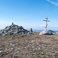
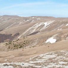
Zeytin-Kosh is a mountain summit in the Crimean Mountains, the third-highest peak in the range at 1537 m (the Ukrainian source gives 1534 m). It lies in the southeastern part of the Babugan-Yayla plateau, and its bare cone-shaped top has gentle northern and western slopes, while ribbed rock ledges border the southern and eastern sides. The summit is built of limestone and marked by karst funnels and karren, with a large erosion-karst valley on the eastern slope.
The name is Crimean Tatar: zeytin means olive, qoş a sheep pen or fold, so Zeytin-Koş is the 'olive sheepfold'. Olive trees grow in quantity at the foot of the peak, and until the 20th century the mountain served as a vast pasture where shepherds drove flocks that grazed here until the winter colds.
The name is Crimean Tatar: zeytin means olive, qoş a sheep pen, so Zeytin-Kosh is the "olive sheepfold". Olive trees grow in large numbers at the foot of the peak, and until the 20th century the mountain was a vast pasture where shepherds drove flocks that grazed here until the winter colds.
Access is officially forbidden without a permit issued by the Crimean Nature Reserve administration, since the summit lies inside the reserve. The usual approaches are the Artek trail from Krasnokamenka over the Gurzuf Saddle, the Talma-Bogaz trail from Maly Mayak, and a nameless path from Zaprudnoye village. The summit is exposed to strong winds.
Zeytin-Kosh is also known by the Crimean Tatar name Balıq Qaşın Qayası. Unlike the other Crimean peaks above 1,500 metres, it lies on the south-eastern slopes of Babugan-Yayla, so its summit opens onto a panorama of the Black Sea. Its surface is marked by karst funnels and karren, and a large erosion-karst valley cuts its eastern slope.
The community of curious travelers
AroundUs brings together thousands of curated places, local tips, and hidden gems, enriched daily by 93,489 contributors worldwide.