Lagoa Azul Lighthouse
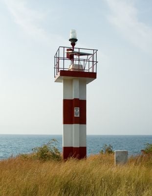
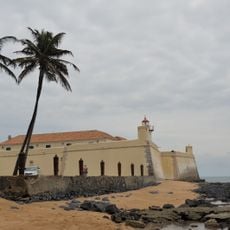
Lagoa Azul Lighthouse, lighthouse in the district of Lobata, São Tomé and Príncipe
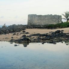
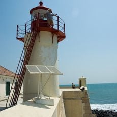
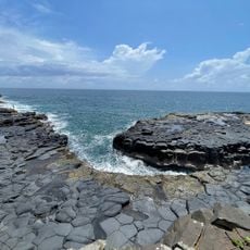
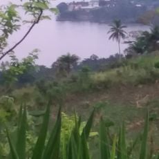
Lagoa Azul Lighthouse is a navigational structure located on the coast of Lobata in São Tomé and Príncipe. Standing at around 5 meters (16 feet) tall, it marks a coastal point and functions as an orientation aid for the maritime area.
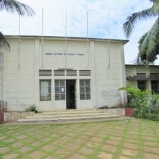
This lighthouse was built during the period of Portuguese presence in the region and represents part of the maritime infrastructure developed during that era. It has remained in place after independence, serving as a reminder of the colonial period.
This lighthouse reflects the maritime heritage of a region shaped by Portuguese influence and remains part of how locals relate to their coastline. The structure connects the community to its seafaring past, marking a significant point in the landscape.
The lighthouse is accessible from the land but offers limited interior access due to its modest height and operational function. Plan to visit during daylight hours to best appreciate the coastal surroundings and take in the view from this point.
This structure is one of the few remaining maritime infrastructure pieces from the Portuguese era that continues to mark the coastline of the archipelago. Its modest scale makes it an unassuming yet meaningful reminder of local seafaring heritage.
Location: Lobata
Inception: September 12, 1997
Height: 5 m
GPS coordinates: 0.40727,6.61014
Latest update: December 6, 2025 17:48
São Tomé and Príncipe is an island nation in the Gulf of Guinea with volcanic mountains, rainforests and Atlantic coastlines. The main island of São Tomé combines natural landscapes with historical traces of colonial cocoa production. Abandoned plantations, known as roças, stand among dense forests, while beaches like Banana Beach and Praia Piscina offer sand and clear water for swimming. The landscape ranges from flat coastal strips to mountains in the interior, where waterfalls such as Cascata de São Nicolau flow through tropical vegetation. Obo National Park protects much of the original rainforest and offers trails through dense vegetation with endemic plants and birds. Pico Cão Grande, a 663-meter (2,175-foot) volcanic rock tower, rises alone from the forest and is visible from several viewpoints. Along the southern coast, a marker near Ilhéu das Rolas marks the equator, which crosses the island. In São Tomé city, the cathedral, Fort São Sebastião and the National Museum recall the Portuguese colonial period, while the Presidential Palace and markets show everyday life today.
Pico Cão Grande
32.5 km
Pico Santo Tomé
16.9 km
Estadio 12 de Julio
16.3 km
Obo National Park
29 km
São Sebastião Museum
15.9 km
São Sebastião Museum
15.9 km
National Lyceum
16.4 km
Presidential Palace of São Tomé e Príncipe
15.7 km
National Library of São Tomé and Príncipe
15.6 km
Forte de São Jerónimo
16.9 km
Our Lady of Conception Church, São Tomé
15.1 km
Supreme Court of São Tomé and Príncipe
15.6 km
São Sebastião Lighthouse
15.9 km
Arquivo Histórico de São Tomé
15.9 km
Saint Nicholas Waterfall
13.6 km
Hellmouth
25.2 km
Jardín Botánico
13.2 km
Praia das Sete Ondas
25.3 km
Roça Água-Izé
24.7 km
Cineteatro Marcelo da Veiga
15.8 km
Mercado Municipal São Tomé
15.4 km
Igreja do Bom Jesus, São Tomé
15.7 km
Igreja de Nossa Senhora de Guadalupe
5.8 km
Praia Picão
22.1 km
Conjuntos Urbanos, São Tomé
15.5 km
Cathedral of São Tomé
15.6 km
Cascata de Bombaim
17.1 km
Rio do Ouro
6 kmVisited this place? Tap the stars to rate it and share your experience / photos with the community! Try now! You can cancel it anytime.
Discover hidden gems everywhere you go!
From secret cafés to breathtaking viewpoints, skip the crowded tourist spots and find places that match your style. Our app makes it easy with voice search, smart filtering, route optimization, and insider tips from travelers worldwide. Download now for the complete mobile experience.
A unique approach to discovering new places❞
— Le Figaro
All the places worth exploring❞
— France Info
A tailor-made excursion in just a few clicks❞
— 20 Minutes