Enable Location

We need your location to show you interesting places around you

Discover nearby places

Find interesting locations and hidden gems around you

Precise directions

Get accurate directions and distances to places

Your location is never shared with other users. It's only used when you tap the location button.

Bridal Veil Falls

Log in to your account

Start exploring — it's free

Trusted by 62,486 travelers worldwide

Continue with Google
Continue with Apple
or

We will send you a code to connect

By continuing, you accept our Terms and Conditions and our Privacy Policy

Check your inbox

We've sent a pincode in your inbox. Please enter the code below.

Bridal Veil Falls

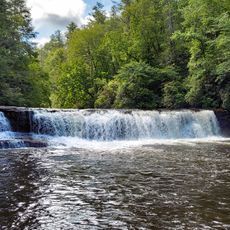
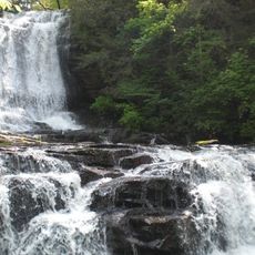
Bridal Veil Falls, Cascading waterfall in DuPont State Forest, North Carolina.

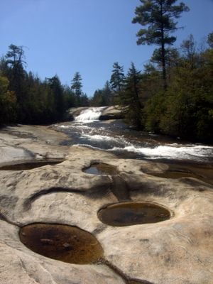
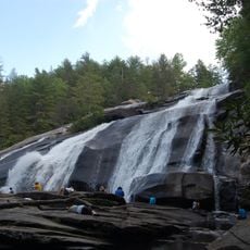
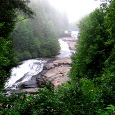
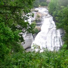
Bridal Veil Falls is a waterfall in DuPont State Forest, North Carolina, where water cascades down a 37 meter granite formation. The descent breaks into two distinct sections, with a steeper upper drop followed by broader stone surfaces that the water spreads across.

The falls gained widespread recognition after appearing in the 1992 film The Last of the Mohicans, which featured scenes filmed at this location. This film appearance transformed how people viewed the place and brought visitors from across the region to experience it.

The falls draw photographers and nature lovers who come to document the flowing water and light patterns through the seasons. People return repeatedly to capture how the cascade changes throughout the year, making it a valued spot for those who appreciate natural beauty.

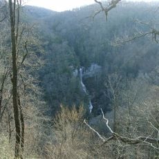
Access to the falls comes via a hiking trail that is roughly 4.6 miles round trip, beginning at the High Falls Trailhead. The route passes near other water features such as Fawn Lake and Corn Mill Shoals, offering visitors multiple viewpoints and places to explore along the way.

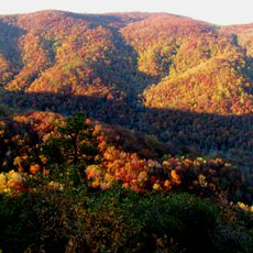
The water takes on different forms depending on the season, flowing as a powerful rush in spring but appearing as thin, broad sheets in summer. These changes make the falls look entirely different throughout the year, offering visitors distinct visual experiences with each visit.

The community of curious travelers

AroundUs brings together thousands of curated places, local tips, and hidden gems, enriched daily by 60,000 contributors worldwide.

Start exploring
Height
37 m
GPS coordinates
35.17710,-82.62130
Latest update
December 8, 2025 20:00
Around this place
DuPont State Forest
United States of America

DuPont State Forest

3.3 km
Table Rock State Park
United States of America

Table Rock State Park

17.5 km
Triple Falls
United States of America

Triple Falls

2.4 km
Caesars Head State Park
United States of America

Caesars Head State Park

7 km
Hooker Falls
United States of America

Hooker Falls

2.8 km
High Falls
United States of America

High Falls

1.9 km
Raven Cliff Falls
United States of America

Raven Cliff Falls

8.8 km
Connestee Falls and Batson Creek Falls
United States of America

Connestee Falls and Batson Creek Falls

10.1 km
Key Falls
United States of America

Key Falls

9.5 km
Holmes Educational State Forest
United States of America

Holmes Educational State Forest

8.2 km
Robinson Rock House Ruin and Plantation Site
United States of America

Robinson Rock House Ruin and Plantation Site

14.1 km
John H. Goodwin House
United States of America

John H. Goodwin House

18.3 km
Flat Rock Historic District
United States of America

Flat Rock Historic District

18 km
Silvermont
United States of America

Silvermont

11.4 km
St. Philip's Episcopal Church
United States of America

St. Philip's Episcopal Church

11.7 km
Charles E. Orr House
United States of America

Charles E. Orr House

11.6 km
Dillard B. and Georgia Sewell House
United States of America

Dillard B. and Georgia Sewell House

9.4 km
Flem Galloway House
United States of America

Flem Galloway House

17.5 km
Godfrey-Barnette House
United States of America

Godfrey-Barnette House

11.9 km
Royal and Louise Morrow House
United States of America

Royal and Louise Morrow House

11.2 km
Transylvania County Courthouse
United States of America

Transylvania County Courthouse

12 km
William H. Grogan House
United States of America

William H. Grogan House

10.4 km
Main Street Historic District
United States of America

Main Street Historic District

12 km
William Deaver House
United States of America

William Deaver House

13.2 km
Hanckel-Barclay House
United States of America

Hanckel-Barclay House

10.2 km
Max and Claire Brombacher House
United States of America

Max and Claire Brombacher House

11.1 km
William Breese, Jr., House
United States of America

William Breese, Jr., House

11.8 km
Co-Ed Cinema
United States of America

Co-Ed Cinema

12.2 km
Show the full map
« Bridal Veil Falls - Cascading waterfall in DuPont State Forest, North Carolina » is provided by Around Us (aroundus.com). Images and texts are derived from Wikimedia project under a Creative Commons license. You are allowed to copy, distribute, and modify copies of this page, under the conditions set by the license, as long as this note is clearly visible.

Discover hidden gems everywhere you go!

From secret cafés to breathtaking viewpoints, skip the crowded tourist spots and find places that match your style. Our app makes it easy with voice search, smart filtering, route optimization, and insider tips from travelers worldwide. Download now for the complete mobile experience.

Around Us App Screenshot

A unique approach to discovering new places

Le Figaro

All the places worth exploring

France Info

A tailor-made excursion in just a few clicks

20 Minutes

Around Us
Travel Guide & Maps
Download

Send to your phone

QR Code
1

Open the camera app on your mobile.

2

Point at the QR code with your camera. A notification will appear.

3

Tap the notification to open the link.