Enable Location

We need your location to show you interesting places around you

Discover nearby places

Find interesting locations and hidden gems around you

Precise directions

Get accurate directions and distances to places

Your location is never shared with other users. It's only used when you tap the location button.

Historic Route 66

Log in to your account

Start exploring — it's free

Trusted by 61,496 travelers worldwide

Continue with Google
Continue with Apple
or

We will send you a code to connect

By continuing, you accept our Terms and Conditions and our Privacy Policy

Check your inbox

We've sent a pincode in your inbox. Please enter the code below.

Historic Route 66, Historic highway from Chicago to Santa Monica in United States.

Description

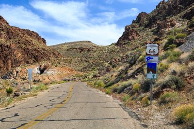
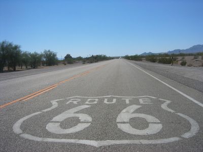
Historic Route 66 is an overland highway spanning 2448 miles (3938 kilometers) across eight states from Illinois to California, linking Chicago to Santa Monica on the Pacific coast. Along the way through Missouri, Kansas, Oklahoma, Texas, New Mexico, and Arizona stand hundreds of restored gas stations, motels, and restaurants from mid-twentieth century America.

History

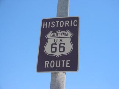
The federal government established the route in 1926 as one of the first numbered highways in the country. During the Dust Bowl of the thirties, thousands of families traveled west seeking agricultural work in California before Interstate highways replaced the old route in the fifties and sixties, leading to official decommissioning in 1985.

Culture

Small towns along the route maintain traditions from the highway's heyday and operate diners styled after mid-century design. Local communities organize car shows and festivals where owners display restored vehicles from the forties and fifties.

Practical

Travelers can follow preserved sections marked with Historic Route 66 signage across multiple states. Several museums document the history along the corridor while restored diners and motels from the forties and fifties offer food and lodging.

Did you know?

Near Amarillo in Texas, ten painted Cadillacs stand buried nose-down in the ground at Cadillac Ranch. Stanley Marsh 3 and art group Ant Farm installed this sculpture in 1974 along the original alignment, and visitors are encouraged to bring spray paint and add their own artwork to the constantly changing automobiles.

Location
Location
Location
Location
Location
Location
Inception
June 15, 2000
Official opening
November 11, 1926
Reference
66
GPS coordinates
39.00695,-89.77948
Latest update
December 14, 2025 18:02

AroundUs brings together thousands of curated places, local tips, and hidden gems, enriched daily by 60,000 contributors worldwide. Discover all places nearby (Arizona).

Around this place
United States of America

WBC Legends of Boxing Museum

2509.6 km
San Bernardino County Court House
United States of America

San Bernardino County Court House

2509.6 km
Slover Mountain
United States of America

Slover Mountain

2515.5 km
Bono's Restaurant and Deli
United States of America

Bono's Restaurant and Deli

2524.9 km
United States of America

Bunker Hill

2512 km
First Christian Church of Rialto
United States of America

First Christian Church of Rialto

2516.4 km
San Bernardino Downtown Station
United States of America

San Bernardino Downtown Station

2509.5 km
Colton Carnegie Library
United States of America

Colton Carnegie Library

2513.8 km
Norman F. Feldheym Library
United States of America

Norman F. Feldheym Library

2509.8 km
Fontana Farms Company Ranch House, Camp No. 1
United States of America

Fontana Farms Company Ranch House, Camp No. 1

2523 km
Aquatic Center
United States of America

Aquatic Center

2522.7 km
San Dimas Experimental Forest
United States of America

San Dimas Experimental Forest

2523.6 km
San Bernardino History and Railroad Museum
United States of America

San Bernardino History and Railroad Museum

2511.3 km
Rathaus von San Bernardino
United States of America

Rathaus von San Bernardino

2509.8 km
United States of America

Shandin Hills Golf Course

2510.6 km
United States of America

Colton Golf Course

2516.8 km
United States of America

Primer Mcdonal's

2509.5 km
United States of America

Sierra Lakes

2521.4 km
United States of America

Sturges Center For The Fine Arts

2509.6 km
United States of America

Fox Theater

2509.6 km

Stage Red Fontana

2522.3 km
United States of America

Greek Theatre

2512.1 km
United States of America

Art Depot Gallery

2522.4 km
United States of America

The Koehler Gallery

2522.4 km
United States of America

Sister Cities Signpost

2509.8 km
United States of America

Fontana Citrus Association

2522.4 km
United States of America

Mural, Work of art

2522.4 km
United States of America

Work of art, statue

2522.2 km
Show the full map
« Historic Route 66 - Historic highway from Chicago to Santa Monica in United States » is provided by Around Us (aroundus.com). Images and texts are derived from Wikimedia project under a Creative Commons license. You are allowed to copy, distribute, and modify copies of this page, under the conditions set by the license, as long as this note is clearly visible.

Discover hidden gems everywhere you go!

From secret cafés to breathtaking viewpoints, skip the crowded tourist spots and find places that match your style. Our app makes it easy with voice search, smart filtering, route optimization, and insider tips from travelers worldwide. Download now for the complete mobile experience.

Around Us App Screenshot

A unique approach to discovering new places

Le Figaro

All the places worth exploring

France Info

A tailor-made excursion in just a few clicks

20 Minutes

Around Us
Travel Guide & Maps
Download

Send to your phone

QR Code
1

Open the camera app on your mobile.

2

Point at the QR code with your camera. A notification will appear.

3

Tap the notification to open the link.