Arthur County

Log in to your account

AroundUs is a community-driven map of interesting places, built by curious explorers like you. It grows with every review, story, and photo you share.
Connect to save your favorite spots, contribute locations, and create personalized routes.
Continue with Google
Continue with Apple
Continue with X
Continue with Facebook
Continue with email
By continuing, you accept our Terms and Conditions and our Privacy Policy
Create an account
Add to collection
Map
Suggest a change
Share

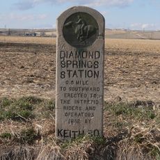
Arthur County, County in western Nebraska, US

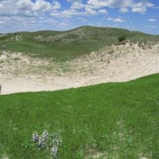
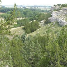
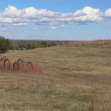
Arthur County is an administrative division in western Nebraska covering vast grasslands and farmland across its territory. The region remains sparsely populated with open plains defining the landscape throughout.

The county was established in 1913 when residents agreed to separate the territory from McPherson County and create an independent administrative region. This division allowed local communities to manage their own affairs more directly.

The population of 434 residents maintains strong connections through regular community gatherings, local traditions, and shared agricultural activities throughout the seasons.

Highways 61 and 92 cross through the area, connecting local communities with neighboring regions and essential services. The main roads allow visitors to explore the territory and reach individual towns.

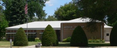
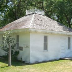
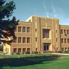
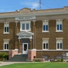
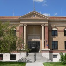
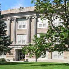
The courthouse built in 1914 ranks among the smallest county administrative buildings ever constructed in the United States, representing an architectural curiosity. This modest structure preserves the historical character of early administrative infrastructure.

Location: Nebraska

Inception: 1887

Capital city: Arthur

Shares border with: Grant County, Keith County, Garden County, Hooker County, McPherson County

Website: https://arthurcounty.nebraska.gov

GPS coordinates: 41.57000,-101.70000

Latest update: December 7, 2025 19:28

Photos
Around this place
Nebraska Sand Hills Mixed Grasslands
United States of America

Nebraska Sand Hills Mixed Grasslands

74.4 km
Lake McConaughy
United States of America

Lake McConaughy

38.4 km
Ash Hollow State Historical Park
United States of America

Ash Hollow State Historical Park

46.3 km
United States of America

Crescent Lake National Wildlife Refuge

56.4 km
Pilgrim Holiness Church
United States of America

Pilgrim Holiness Church

960 m
First Arthur County Courthouse and Jail
United States of America

First Arthur County Courthouse and Jail

833 m
O'Fallons Bluff
United States of America

O'Fallons Bluff

69.9 km
Wallace W. Waterman Sod House
United States of America

Wallace W. Waterman Sod House

52.6 km
Standard Oil Red Crown Service Station
United States of America

Standard Oil Red Crown Service Station

49.4 km
Golden Spike Tower and Visitor Center
United States of America

Golden Spike Tower and Visitor Center

86.8 km
Sedgwick County Courthouse
United States of America

Sedgwick County Courthouse

80.1 km
Grant City Park
United States of America

Grant City Park

80.4 km
Rackett Grange Hall No. 318
United States of America

Rackett Grange Hall No. 318

43.3 km
Lisco State Aid Bridge
United States of America

Lisco State Aid Bridge

77.6 km
Lewellen State Aid Bridge
United States of America

Lewellen State Aid Bridge

46.4 km
Deuel County Courthouse
United States of America

Deuel County Courthouse

83.4 km
Leonidas A. Brandhoefer Mansion
United States of America

Leonidas A. Brandhoefer Mansion

48.6 km
Fred and Minnie Meyer Sudman House
United States of America

Fred and Minnie Meyer Sudman House

83.4 km
Garden County Courthouse
United States of America

Garden County Courthouse

56.6 km
Grant Commercial Historic District
United States of America

Grant Commercial Historic District

81.2 km
Oshkosh Water Tower
United States of America

Oshkosh Water Tower

56.7 km
Hooker County Courthouse
United States of America

Hooker County Courthouse

75.6 km
Perkins County Courthouse
United States of America

Perkins County Courthouse

81.1 km
Dr. Burdette and Myrna Gainsforth House
United States of America

Dr. Burdette and Myrna Gainsforth House

48.2 km
District No. 119 North School
United States of America

District No. 119 North School

72.4 km
Sutherland State Aid Bridge
United States of America

Sutherland State Aid Bridge

71 km
Diamond Springs Stage Station Site
United States of America

Diamond Springs Stage Station Site

57.2 km
Hippodrome Theatre
United States of America

Hippodrome Theatre

80.2 km
Show the full map
Reviews

Visited this place? Tap the stars to rate it and share your experience / photos with the community! Try now! You can cancel it anytime.

« Arthur County - County in western Nebraska, US » is provided by Around Us (aroundus.com). Images and texts are derived from Wikimedia project under a Creative Commons license. You are allowed to copy, distribute, and modify copies of this page, under the conditions set by the license, as long as this note is clearly visible.

Discover hidden gems everywhere you go!

From secret cafés to breathtaking viewpoints, skip the crowded tourist spots and find places that match your style. Our app makes it easy with voice search, smart filtering, route optimization, and insider tips from travelers worldwide. Download now for the complete mobile experience.

Around Us App Screenshot

A unique approach to discovering new places

Le Figaro

All the places worth exploring

France Info

A tailor-made excursion in just a few clicks

20 Minutes