Chickamauga Lake, Reservoir in Tennessee River Valley, United States.
Chickamauga Lake runs roughly 59 miles (95 km) along the Tennessee River through southeastern Tennessee, forming a long ribbon of water across several counties. The shoreline stretches about 810 miles and includes coves, inlets, and peninsulas backed by wooded hills and low-lying banks.
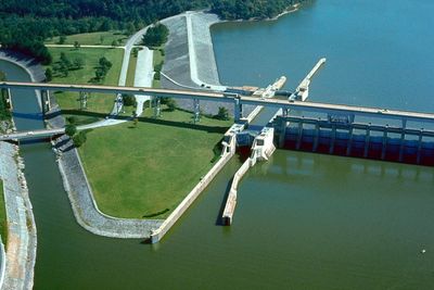
The Tennessee Valley Authority completed the Chickamauga Dam in 1940, creating a large reservoir for flood control and navigation on the middle Tennessee River. The dam was part of a series of projects that transformed the river during the 1930s and 1940s and developed the valley economically.
The reservoir bears the name of the Chickamauga Cherokee people who inhabited the region before the establishment of the water management system.
The water rises gradually in spring and reaches its higher summer level by mid-May, making conditions better for boating and other activities on the water. During winter and early spring the level runs lower, which leaves some shoreline areas and landings less accessible.
An angler caught a largemouth bass here in February 2015 that weighed over 15 pounds and set a record. Specialized stocking programs over the years produced large specimens that made the reservoir well known among sport fishers.
The community of curious travelers
AroundUs brings together thousands of curated places, local tips, and hidden gems, enriched daily by 60,000 contributors worldwide.