Enable Location

We need your location to show you interesting places around you

Discover nearby places

Find interesting locations and hidden gems around you

Precise directions

Get accurate directions and distances to places

Your location is never shared with other users. It's only used when you tap the location button.

Revolutionary War Cemetery

Log in to your account

Start exploring — it's free

Trusted by 62,410 travelers worldwide

Continue with Google
Continue with Apple
or

We will send you a code to connect

By continuing, you accept our Terms and Conditions and our Privacy Policy

Check your inbox

We've sent a pincode in your inbox. Please enter the code below.

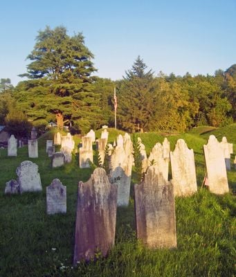
Revolutionary War Cemetery, cemetery

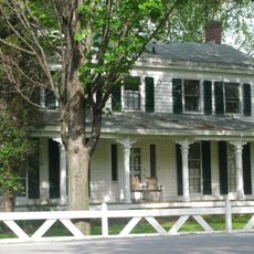
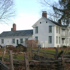
The Revolutionary War Cemetery is a historic burial ground in Salem marked by simple stones and grave markers dating from the late 1700s. The graves are arranged in an informal layout, with trees and grass surrounding the headstones and weathered inscriptions recording the names of early settlers and soldiers.

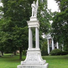
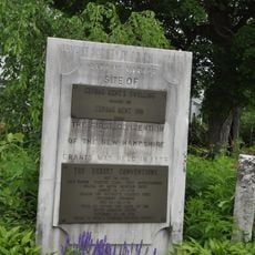
The cemetery was established after Scottish settlers founded Salem in 1764 and an Irish Presbyterian minister arrived with his congregation. During the American Revolution, many soldiers were buried here, making the site an important memorial to the region's early history.

The cemetery reflects the Scottish and Irish roots of the early settlers who founded Salem starting in 1764. Stone burial vaults recall Celtic burial traditions and show how the community honored its dead.

The cemetery is located on Archibald Street and is accessible from dawn to dusk year-round. The site welcomes foot traffic, pets are allowed on leash, and on-site tours are available to share stories about Salem and the soldiers buried there.

Local legend holds that about 100 American soldiers from the Battle of Saratoga were buried here in an unmarked mass grave, though this remains unconfirmed. The cemetery also contains stones carved by Vermont stoneworker Zerubbabel Collins, recognizable by his signature rounded angel heads.

The community of curious travelers

AroundUs brings together thousands of curated places, local tips, and hidden gems, enriched daily by 60,000 contributors worldwide.

Start exploring
Location
Inception
1767
GPS coordinates
43.16694,-73.32944
Latest update
February 7, 2026 11:40
Around this place
Hildene
United States of America

Hildene

20.5 km
Equinox Mountain
United States of America

Equinox Mountain

17.1 km
General Schuyler House
United States of America

General Schuyler House

22 km
Shushan Bridge
United States of America

Shushan Bridge

8.5 km
Eagleville Bridge
United States of America

Eagleville Bridge

9.4 km
Rexleigh Bridge
United States of America

Rexleigh Bridge

4.2 km
The American Museum of Fly Fishing
United States of America

The American Museum of Fly Fishing

21.3 km
Arlington Green Covered Bridge
United States of America

Arlington Green Covered Bridge

11.3 km
Manley-Lefevre House
United States of America

Manley-Lefevre House

20.9 km
Salem Historic District
United States of America

Salem Historic District

615 m
Equinox House Historic District
United States of America

Equinox House Historic District

20.8 km
Chiselville Covered Bridge
United States of America

Chiselville Covered Bridge

19.1 km
Burton Hall
United States of America

Burton Hall

17.4 km
Cambridge Historic District
United States of America

Cambridge Historic District

16.1 km
Elisha Straight House
United States of America

Elisha Straight House

22.3 km
East Arlington Village Historic District
United States of America

East Arlington Village Historic District

19.1 km
Gov. Jonas Galusha Homestead
United States of America

Gov. Jonas Galusha Homestead

22.3 km
Dorset Village Historic District
United States of America

Dorset Village Historic District

21.1 km
Fort Miller Reformed Church Complex
United States of America

Fort Miller Reformed Church Complex

20.5 km
Col. Sidney Berry House
United States of America

Col. Sidney Berry House

21.4 km
White Creek Historic District
United States of America

White Creek Historic District

22 km
Village of Greenwich Historic District
United States of America

Village of Greenwich Historic District

16.1 km
Amos Lawrence House
United States of America

Amos Lawrence House

22.4 km
Kent Neighborhood Historic District
United States of America

Kent Neighborhood Historic District

20.4 km
Hard Farm Homestead
United States of America

Hard Farm Homestead

20.5 km
Rupert Village Historic District
United States of America

Rupert Village Historic District

13.5 km
Pastime Pinball
United States of America

Pastime Pinball

22.1 km
The Georgi on the Battenkill Community Park & Museum
United States of America

The Georgi on the Battenkill Community Park & Museum

8.8 km
Show the full map
« Revolutionary War Cemetery - cemetery » is provided by Around Us (aroundus.com). Images and texts are derived from Wikimedia project under a Creative Commons license. You are allowed to copy, distribute, and modify copies of this page, under the conditions set by the license, as long as this note is clearly visible.

Discover hidden gems everywhere you go!

From secret cafés to breathtaking viewpoints, skip the crowded tourist spots and find places that match your style. Our app makes it easy with voice search, smart filtering, route optimization, and insider tips from travelers worldwide. Download now for the complete mobile experience.

Around Us App Screenshot

A unique approach to discovering new places

Le Figaro

All the places worth exploring

France Info

A tailor-made excursion in just a few clicks

20 Minutes

Around Us
Travel Guide & Maps
Download

Send to your phone

QR Code
1

Open the camera app on your mobile.

2

Point at the QR code with your camera. A notification will appear.

3

Tap the notification to open the link.