Chest opened
+${chestReward.xp} XP
Explorer
NOUVEAU ×${chestReward.collectible.quantity}
tapez pour fermer
Chest locked

Open chests in the app

Around Us is built for your phone — chests unlock when you walk, explore and capture nearby places.

Enable Location

We need your location to show you interesting places around you

Discover nearby places

Find interesting locations and hidden gems around you

Precise directions

Get accurate directions and distances to places

Your location is never shared with other users. It's only used when you tap the location button.

Market–Frankford Line

Log in to your account

Start exploring — it's free

Trusted by 73,027 travelers worldwide

Continue with Google
Continue with Apple
or

We will send you a code to connect

By continuing, you accept our Terms and Conditions and our Privacy Policy

Check your inbox

We've sent a pincode in your inbox. Please enter the code below.

Market–Frankford Line
Discussion Reviews 2 Photos
49.1k Popularity

Market–Frankford Line, Rapid transit railway line in Upper Darby Township, United States

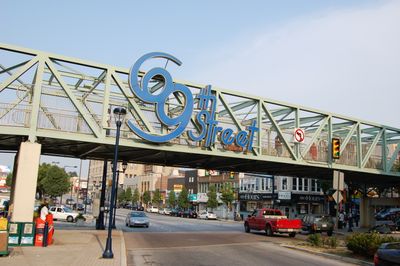
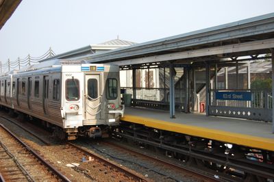
The Market-Frankford Line is a rapid transit railway serving the Philadelphia region, running from 69th Street Transportation Center to Frankford Transportation Center. The route combines sections of elevated tracks with underground tunnels while serving a total of 28 stations.

The original section was funded privately by Philadelphia Rapid Transit Company without public money, opening between City Hall and 23rd Street from 1903 to 1905. This private beginning shaped how the system developed afterward.

The railway line serves multiple communities across Philadelphia, connecting residential areas, educational centers, shopping districts, and employment hubs throughout the metropolitan region.

Passengers board easily using SEPTA Key cards and can expect service during standard operating hours. Trains run at regular intervals throughout the day, with shorter gaps during the busiest periods.

The construction was completed without using taxpayer money, which was unusual for such a large transit system. This type of financing set it apart fundamentally from other urban rail networks of that era.

The community of curious travelers

AroundUs brings together thousands of curated places, local tips, and hidden gems, enriched daily by 60,000 contributors worldwide.

Start exploring
Official opening
March 4, 1907
GPS coordinates
39.94988,-75.14368
Latest update
December 14, 2025 18:58
Around this place
First Bank of the United States
United States of America

First Bank of the United States

308 m
Second Bank of the United States
United States of America

Second Bank of the United States

421 m
Carpenters' Hall
United States of America

Carpenters' Hall

360 m
Betsy Ross House
United States of America

Betsy Ross House

270 m
Christ Church, Philadelphia
United States of America

Christ Church, Philadelphia

95 m
Old City
United States of America

Old City

463 m
Science History Institute
United States of America

Science History Institute

264 m
City Tavern
United States of America

City Tavern

340 m
Union Fire Company
United States of America

Union Fire Company

77 m
Franklin Court
United States of America

Franklin Court

250 m
Walnut Street Prison
United States of America

Walnut Street Prison

428 m
United States of America

Sculpture of the United States

359 m
Congregation Mikveh Israel
United States of America

Congregation Mikveh Israel

335 m
Philadelphia Bourse
United States of America

Philadelphia Bourse

397 m
Merchants' Exchange Building
United States of America

Merchants' Exchange Building

349 m
Weitzman National Museum of American Jewish History
United States of America

Weitzman National Museum of American Jewish History

422 m
National Liberty Museum
United States of America

National Liberty Museum

296 m
Slate Roof House
United States of America

Slate Roof House

293 m
Arden Theatre Company
United States of America

Arden Theatre Company

139 m
Museum of the American Revolution
United States of America

Museum of the American Revolution

250 m
Provident Life & Trust Company
United States of America

Provident Life & Trust Company

357 m
Museum of Illusions Philadelphia
United States of America

Museum of Illusions Philadelphia

332 m
Free Quaker Meetinghouse
United States of America

Free Quaker Meetinghouse

332 m
Thomas Bond House
United States of America

Thomas Bond House

267 m
Benjamin Loxley house
United States of America

Benjamin Loxley house

330 m
The Center for Art in Wood
United States of America

The Center for Art in Wood

394 m
Mercantile Library Company
United States of America

Mercantile Library Company

219 m
Fireman's Hall Museum
United States of America

Fireman's Hall Museum

387 m
Show the full map
Reviews
Share your experience

No review yet

Discussions
Start a discussion...

No discussion yet

« Market–Frankford Line - Rapid transit railway line in Upper Darby Township, United States » is provided by Around Us (aroundus.com). Images and texts are derived from Wikimedia project under a Creative Commons license. You are allowed to copy, distribute, and modify copies of this page, under the conditions set by the license, as long as this note is clearly visible.

Discover hidden gems everywhere you go!

From secret cafés to breathtaking viewpoints, skip the crowded tourist spots and find places that match your style. Our app makes it easy with voice search, smart filtering, route optimization, and insider tips from travelers worldwide. Download now for the complete mobile experience.

Around Us App Screenshot

A unique approach to discovering new places

Le Figaro

All the places worth exploring

France Info

A tailor-made excursion in just a few clicks

20 Minutes

Around Us
Travel Guide & Maps
Download

Send to your phone

QR Code
1

Open the camera app on your mobile.

2

Point at the QR code with your camera. A notification will appear.

3

Tap the notification to open the link.