Chest opened
+${chestReward.xp} XP
Explorer
NOUVEAU ×${chestReward.collectible.quantity}
tapez pour fermer
Chest locked

Open chests in the app

Around Us is built for your phone — chests unlock when you walk, explore and capture nearby places.

Enable Location

We need your location to show you interesting places around you

Discover nearby places

Find interesting locations and hidden gems around you

Precise directions

Get accurate directions and distances to places

Your location is never shared with other users. It's only used when you tap the location button.

Penns Grove

Log in to your account

Start exploring — it's free

Trusted by 72,886 travelers worldwide

Continue with Google
Continue with Apple
or

We will send you a code to connect

By continuing, you accept our Terms and Conditions and our Privacy Policy

Check your inbox

We've sent a pincode in your inbox. Please enter the code below.

Discussion Reviews 1 Photos
20k Popularity

Penns Grove, Borough in Salem County, New Jersey

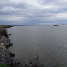
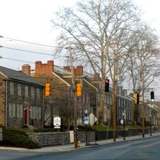
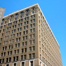
Penns Grove is a borough in Salem County located directly along the Delaware River across from Wilmington, featuring residential neighborhoods and waterfront areas. The community spans a compact area that mixes residential streets with river access.

The area separated from Upper Penns Neck Township and became officially established in 1894 through local referendum. This split followed the region's growth driven by industrial development in the 19th century.

Italian immigrants from Valle San Giovanni left lasting marks in this place while working in the neighboring industrial area, passing down their traditions through generations.

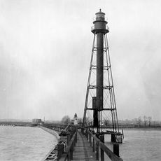
The borough sits directly on the water, offering easy access to the riverfront for outdoor activities. Visitors should expect small residential streets and can explore the waterfront areas when conditions are favorable.

The place sits near the historic DuPont plant in Carneys Point, which shaped the economic development of the entire region. This industrial heritage remains visible in the community's makeup and character today.

The community of curious travelers

AroundUs brings together thousands of curated places, local tips, and hidden gems, enriched daily by 60,000 contributors worldwide.

Start exploring
Location
Inception
March 8, 1894
Elevation above the sea
3 m
Shares border with
Carneys Point Township
GPS coordinates
39.72806,-75.46778
Latest update
December 7, 2025 10:06
Around this place
Delaware Memorial Bridge
United States of America

Delaware Memorial Bridge

6.2 km
Fort Christina
United States of America

Fort Christina

6.1 km
Bellevue State Park
United States of America

Bellevue State Park

6.2 km
Dudley Spencer House
United States of America

Dudley Spencer House

6.6 km
Wilmington Park
United States of America

Wilmington Park

5.6 km
I.M. Pei Building
United States of America

I.M. Pei Building

7 km
P. S. Dupont High School
United States of America

P. S. Dupont High School

6.9 km
Fox Point State Park
United States of America

Fox Point State Park

3.6 km
Brandywine Village Historic District
United States of America

Brandywine Village Historic District

6.8 km
St. Mary of the Immaculate Conception Church
United States of America

St. Mary of the Immaculate Conception Church

6.7 km
Marcus Hook Range Rear Light
United States of America

Marcus Hook Range Rear Light

4.9 km
St. Joseph's Catholic Church
United States of America

St. Joseph's Catholic Church

6.9 km
Hendrickson House
United States of America

Hendrickson House

6.4 km
Delaware Trust Building
United States of America

Delaware Trust Building

7 km
Christiana Light
United States of America

Christiana Light

4.6 km
Bellevue Range Rear Light
United States of America

Bellevue Range Rear Light

4.4 km
St. Mary's School
United States of America

St. Mary's School

6.7 km
Dr. John A. Brown House
United States of America

Dr. John A. Brown House

5 km
Cherry Island Range Rear Light
United States of America

Cherry Island Range Rear Light

4.2 km
Church Street Historic District (Wilmington, Delaware)
United States of America

Church Street Historic District (Wilmington, Delaware)

6.4 km
Riverview Cemetery
United States of America

Riverview Cemetery

6.4 km
Mount Pleasant Methodist Episcopal Church and Parsonage
United States of America

Mount Pleasant Methodist Episcopal Church and Parsonage

6 km
East Brandywine Historic District
United States of America

East Brandywine Historic District

6.7 km
Christiana North Jetty Light
United States of America

Christiana North Jetty Light

3.8 km
Kingswood Methodist Episcopal Church
United States of America

Kingswood Methodist Episcopal Church

5.8 km
Rosemont
United States of America

Rosemont

5.2 km
Starr House
United States of America

Starr House

6.9 km
New Castle Leather Raw Stock Warehouse
United States of America

New Castle Leather Raw Stock Warehouse

6.7 km
Show the full map
Reviews
Share your experience

No review yet

Discussions
Start a discussion...

No discussion yet

« Penns Grove - Borough in Salem County, New Jersey » is provided by Around Us (aroundus.com). Images and texts are derived from Wikimedia project under a Creative Commons license. You are allowed to copy, distribute, and modify copies of this page, under the conditions set by the license, as long as this note is clearly visible.

Discover hidden gems everywhere you go!

From secret cafés to breathtaking viewpoints, skip the crowded tourist spots and find places that match your style. Our app makes it easy with voice search, smart filtering, route optimization, and insider tips from travelers worldwide. Download now for the complete mobile experience.

Around Us App Screenshot

A unique approach to discovering new places

Le Figaro

All the places worth exploring

France Info

A tailor-made excursion in just a few clicks

20 Minutes

Around Us
Travel Guide & Maps
Download

Send to your phone

QR Code
1

Open the camera app on your mobile.

2

Point at the QR code with your camera. A notification will appear.

3

Tap the notification to open the link.