Chest opened
+${chestReward.xp} XP
Explorer
NOUVEAU ×${chestReward.collectible.quantity}
tapez pour fermer
Chest locked

Open chests in the app

Around Us is built for your phone — chests unlock when you walk, explore and capture nearby places.

Enable Location

We need your location to show you interesting places around you

Discover nearby places

Find interesting locations and hidden gems around you

Precise directions

Get accurate directions and distances to places

Your location is never shared with other users. It's only used when you tap the location button.

Log in to your account

Start exploring — it's free

Trusted by 72,882 travelers worldwide

Continue with Google
Continue with Apple
or

We will send you a code to connect

By continuing, you accept our Terms and Conditions and our Privacy Policy

Check your inbox

We've sent a pincode in your inbox. Please enter the code below.

Tippecanoe River
Discussion Reviews Photo
13.1k Popularity

Tippecanoe River, River system in northern Indiana, United States.

The Tippecanoe River is a river system in northern Indiana that flows for about 166 miles through forests and open fields before joining the Wabash River. Along its course, it passes through and connects to many natural lakes across the region.

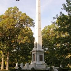
The Battle of Tippecanoe took place in 1811 near the river's junction, where General William Henry Harrison defeated Shawnee forces led by The Prophet. This clash marked a turning point in relations between settlers and Native Americans in the area.

The river's name comes from a Miami-Illinois word meaning buffalo fish, showing how indigenous peoples once valued this waterway. Locals still use this name, keeping alive the memory of that ancient connection to the land.

Two hydroelectric dams built in the 1920s have created lakes that provide recreation and power generation for the region. Visitors can boat, fish, and swim in these lakes while exploring the forests and shores that surround them.

The river system shelters a remarkable diversity of freshwater mussels that thrive in its waters and catch the attention of naturalists. Few visitors realize how important these creatures are to the health of the waterway.

The community of curious travelers

AroundUs brings together thousands of curated places, local tips, and hidden gems, enriched daily by 60,000 contributors worldwide.

Start exploring
Location
GPS coordinates
40.51500,-86.78556
Latest update
December 7, 2025 20:41
Around this place
United States of America

Wabash and Erie Canal

12.3 km
Prophetstown State Park
United States of America

Prophetstown State Park

4.4 km
Tippecanoe Battlefield Park
United States of America

Tippecanoe Battlefield Park

5.1 km
Cairo Skywatch Tower
United States of America

Cairo Skywatch Tower

12.1 km
Happy Hollow Heights Historic District
United States of America

Happy Hollow Heights Historic District

12.6 km
Carroll County Courthouse
United States of America

Carroll County Courthouse

12.3 km
Soldiers and Sailors Monument
United States of America

Soldiers and Sailors Monument

12.3 km
Hershey House
United States of America

Hershey House

8 km
Perrin Historic District
United States of America

Perrin Historic District

13.2 km
Murphy Memorial Drinking Fountain
United States of America

Murphy Memorial Drinking Fountain

12.2 km
Indiana State Soldiers Home Historic District
United States of America

Indiana State Soldiers Home Historic District

10 km
James Pierce Jr. House
United States of America

James Pierce Jr. House

12.9 km
Pulaski County Bridge No. 31
United States of America

Pulaski County Bridge No. 31

11.5 km
Delphi Courthouse Square Historic District
United States of America

Delphi Courthouse Square Historic District

12.3 km
Delphi City Hall
United States of America

Delphi City Hall

12.4 km
Battle Ground Historic District
United States of America

Battle Ground Historic District

4.6 km
Foreman-Case House
United States of America

Foreman-Case House

12.6 km
Barnett-Seawright-Wilson House
United States of America

Barnett-Seawright-Wilson House

12.5 km
Ely Homestead
United States of America

Ely Homestead

8.2 km
Curtis-Grace House
United States of America

Curtis-Grace House

12.8 km
Park Mary Historic District
United States of America

Park Mary Historic District

12.9 km
Delphi Methodist Episcopal Church
United States of America

Delphi Methodist Episcopal Church

12.5 km
Waldron-Beck House and Carriage House
United States of America

Waldron-Beck House and Carriage House

12.4 km
Niewerth Building
United States of America

Niewerth Building

12.4 km
Prophetstown Aquatic Center
United States of America

Prophetstown Aquatic Center

3.9 km
Museums At Prophetstown
United States of America

Museums At Prophetstown

5 km
Delphi Public Library
United States of America

Delphi Public Library

12.5 km
O'Connor Bridge
United States of America

O'Connor Bridge

12.5 km
Show the full map
Reviews
Share your experience

No review yet

Discussions
Start a discussion...

No discussion yet

« Tippecanoe River - River system in northern Indiana, United States » is provided by Around Us (aroundus.com). Images and texts are derived from Wikimedia project under a Creative Commons license. You are allowed to copy, distribute, and modify copies of this page, under the conditions set by the license, as long as this note is clearly visible.

Discover hidden gems everywhere you go!

From secret cafés to breathtaking viewpoints, skip the crowded tourist spots and find places that match your style. Our app makes it easy with voice search, smart filtering, route optimization, and insider tips from travelers worldwide. Download now for the complete mobile experience.

Around Us App Screenshot

A unique approach to discovering new places

Le Figaro

All the places worth exploring

France Info

A tailor-made excursion in just a few clicks

20 Minutes

Around Us
Travel Guide & Maps
Download

Send to your phone

QR Code
1

Open the camera app on your mobile.

2

Point at the QR code with your camera. A notification will appear.

3

Tap the notification to open the link.